25th Annual Black Diamond Fall Fundraising Party
Thursday, September 13; 6:00-10:00 PM; Black Diamond Parking Lot
25th Annual Black Diamond Fall Fundraising Party
Thursday, September 13; 6:00-10:00 PM; Black Diamond Parking Lot
| Advisory: Logan Area Mountains | Issued by Toby Weed for Saturday - January 6, 2018 - 6:50am |
|---|

|
bottom line Areas with heightened avalanche conditions still exist on some steep shady or north facing slopes. Human triggered persistent slab avalanches are possible. Accumulation of moist snow today could cause the danger to rise, and heightened conditions to become more widespread.
|
 |
special announcement Discount lift tickets for Alta, Snowbird, Brighton, Solitude, Deer Valley, Snowbasin, and Beaver Mountain are now available, donated by the resorts to benefit the Utah Avalanche Center. Details and order information here. All proceeds go towards paying for avalanche forecasting and education! |
 |
current conditions The Tony Grove Snotel at 8400' reports 31°F and 40 inches of total snow containing 96% of normal SWE (Snow Water Equivalent). It's 26°F at the 9700' CSI Logan Peak weather station, and the wind is from the south, 15 mph with a 32 mph gust. There's not really any powder and upper elevation slopes were hammered by last week's sustained west wind, but sheltered shady slopes have nice soft and fast recrystalized surface snow. The snow continues to stabilize, and no new avalanches were reported so far in the new year. The snow is shallow and very weak in many areas, especially at lower and mid elevations and outside of the Central Bear River Range.
|
 |
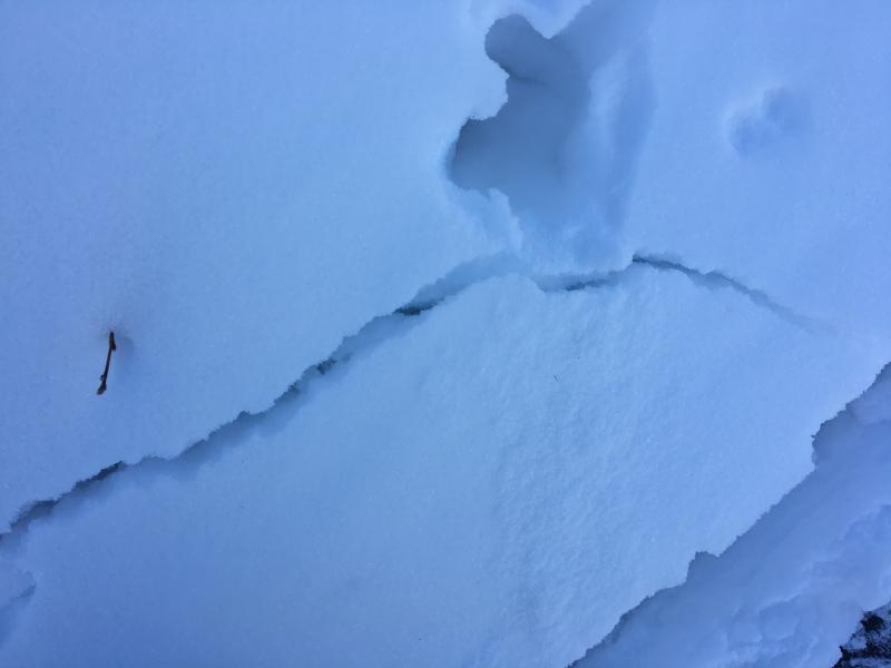
recent activity No avalanches were reported recently...
|
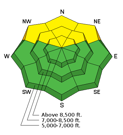
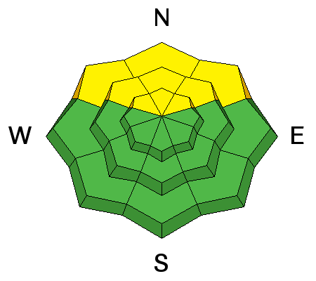
| type | aspect/elevation | characteristics |
|---|

|
|
LIKELIHOOD
 LIKELY
UNLIKELY
SIZE
 LARGE
SMALL
TREND
 INCREASING DANGER
SAME
DECREASING DANGER
|
|
description
Persistent slab avalanches are possible on steep slopes with poor snow structure. We found reasonably good stability Thursday in the Tony Grove Area, but slopes with suspect poor snow structure exist in some areas in the Logan Zone, especially in previously drifted, shallow rocky areas and in outlying terrain. With clear dry nights, the snow in the backcountry continues to become faceted and weak. A few inches of moist snow today could cause the danger to rise and become more widespread.
|
 |
weather A weak storm system will cross the area today through tonight. High pressure will briefly return on Sunday, with another more potent system impacting the region during the middle portion of next week.
Models are now in good agreement that a stronger Pacific storm with potential to bring widespread and significant snow to most of Utah will impact the area in the middle of next week. Keep your fingers crossed, and stay tuned. We'll be watching this one carefully. |
| general announcements We're excited to introduce for the 2017/2018 winter the Utah Avalanche Center podcast, hosted by forecaster Drew Hardesty and produced by KUER's Benjamin Bombard. The podcast will include engaging stories, interviews, and lessons learned - all things avalanche to help keep people on top of the snow instead of buried beneath it - and easily found on ITunes, Stitcher, the UAC blog, or wherever you get your podcasts. Now is a great time to practice companion rescue techniques with your backcountry partners. Here's our rescue practice video. Go HERE for a list of UAC classes. EMAIL ADVISORY: If you would like to get the daily advisory by email you will need to subscribe here. Benefit the Utah Avalanche Center when you shop from Backcountry.com or REI: Click this link for Backcountry.com or this link to REI, shop, and they will donate a percent of your purchase price to the UAC. Both offer free shipping (with some conditions) so this costs you nothing! Benefit the Utah Avalanche Center when you buy or sell on ebay - set the Utah Avalanche Center as a favorite non-profit in your ebay account here and click on ebay gives when you buy or sell. You can choose to have your seller fees donated to the UAC, which doesn't cost you a penny. Remember your information can save lives. If you see anything we should know about, please help us out by submitting snow and avalanche observations. You can also call us at 801-524-5304, email by clicking HERE, or include #utavy in your tweet or Instagram. This advisory is from the U.S.D.A. Forest Service, which is solely responsible for its content. This advisory describes general avalanche conditions and local variations always occur. |