25th Annual Black Diamond Fall Fundraising Party
Thursday, September 13; 6:00-10:00 PM; Black Diamond Parking Lot
25th Annual Black Diamond Fall Fundraising Party
Thursday, September 13; 6:00-10:00 PM; Black Diamond Parking Lot
| Advisory: Logan Area Mountains | Issued by Toby Weed for Monday - December 25, 2017 - 6:49am |
|---|

|
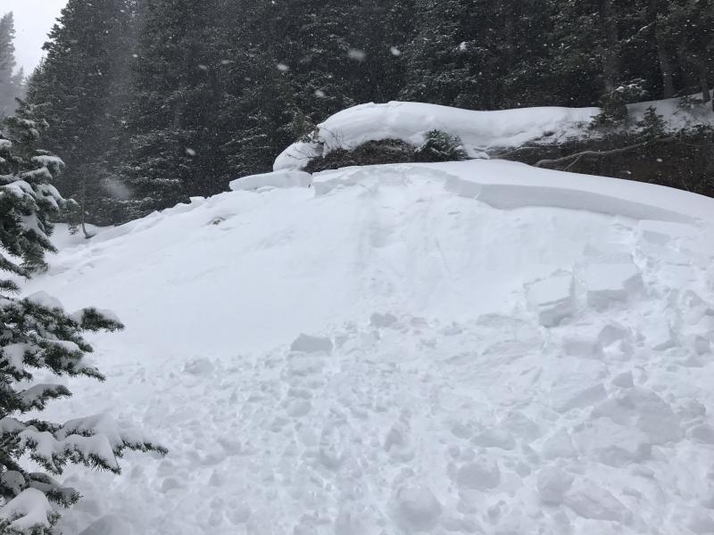
bottom line There is a HIGH avalanche danger on drifted upper elevation slopes in the backcountry. Dangerous avalanche conditions exist at all elevations and human triggered avalanches are likely.
|
 |
avalanche warning THE FOREST SERVICE UTAH AVALANCHE CENTER IN SALT LAKE CITY HAS ISSUED A BACKCOUNTRY AVALANCHE WARNING. * TIMING...IN EFFECT FROM 6 AM MST THIS MORNING TO 6 AM MST TUESDAY MORNING. * AFFECTED AREA...FOR THE MOUNTAINS OF NORTHERN UTAH INCLUDING THE BEAR RIVER RANGE, WESTERN UINTAS, AND ALL THE WASATCH RANGE, INCLUDING THE OGDEN, PROVO, SALT LAKE AND PARK CITY AREA MOUNTAINS. * AVALANCHE DANGER...THE AVALANCHE DANGER FOR THE WARNING AREA IS HIGH TODAY. * REASON/IMPACTS...RECENT SNOW AND WIND HAVE CREATED WIDESPREAD AREAS OF UNSTABLE SNOW. BOTH HUMAN TRIGGERED AND NATURAL AVALANCHES ARE LIKELY. STAY OFF OF AND OUT FROM UNDER SLOPES STEEPER THAN 30 DEGREES. AVALANCHES CAN BE TRIGGERED REMOTELY FROM A DISTANCE AND FROM BELOW. BACKCOUNTRY TRAVELERS SHOULD CONSULT WWW.UTAHAVALANCHECENTER.ORG OR CALL 1-888-999-4019 FOR MORE DETAILED INFORMATION. THIS WARNING DOES NOT APPLY TO SKI AREAS WHERE AVALANCHE HAZARD REDUCTION MEASURES ARE PERFORMED. |
 |
special announcement We're excited to introduce for the 2017/2018 winter the Utah Avalanche Center podcast, hosted by forecaster Drew Hardesty and produced by KUER's Benjamin Bombard. The podcast will include engaging stories, interviews, and lessons learned - all things avalanche to help keep people on top of the snow instead of buried beneath it - and easily found on ITunes, Stitcher, the UAC blog, or wherever you get your podcasts. |
 |
current conditions Dangerous avalanche conditions exist in the backcountry on Christmas Day. The Tony Grove Snotel at 8400' reports 23°F and 45 inches of total snow containing 102% of normal SWE (Snow Water Equivalent). 17 inches of new snow accumulated Saturday, and a couple more fell last night, with 2.8" SWE at the site since Friday, 12/22/17. It's 18°F at the 9700' CSI Logan Peak weather station, and a west wind is blowing at 15 mph, with gusts to 39 mph.
|
 |
recent activity
We received reports of numerous natural, easily triggered, and remote triggered soft slab avalanches across the Logan Zone Saturday 12/23/17. |
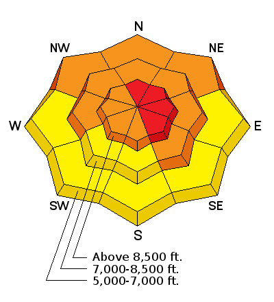
| type | aspect/elevation | characteristics |
|---|

|
|
LIKELIHOOD
 LIKELY
UNLIKELY
SIZE
 LARGE
SMALL
TREND
 INCREASING DANGER
SAME
DECREASING DANGER
|
|
description
Across the Logan Zone, wind slabs formed on weak preexisting snow. Very dangerous wind slab avalanche conditions exist in exposed terrain at upper elevations, with natural activity and large avalanches possible. Human triggered avalanches are likely on drifted slopes at all elevations.
|
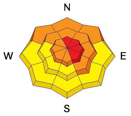
| type | aspect/elevation | characteristics |
|---|

|
|
LIKELIHOOD
 LIKELY
UNLIKELY
SIZE
LARGE
SMALL
TREND
 INCREASING DANGER
SAME
DECREASING DANGER
|
|
description
As the fresh Christmas snow stacks up on slopes plagued by very weak sugary or faceted snow, persistent slab avalanches are likely even in sheltered areas.
|
 |
weather The Christmas storm will gradually exit northern Utah today. A generally dry northwest flow will follow for through midweek.
|
| general announcements Discount lift tickets for Alta, Snowbird, Brighton, Solitude, Deer Valley, Snowbasin, and Beaver Mountain are now available, donated by the resorts to benefit the Utah Avalanche Center. Details and order information here. All proceeds go towards paying for avalanche forecasting and education! Now is a great time to practice companion rescue techniques with your backcountry partners. Here's our rescue practice video. Go HERE for a list of UAC classes. EMAIL ADVISORY: If you would like to get the daily advisory by email you will need to subscribe here. Benefit the Utah Avalanche Center when you shop from Backcountry.com or REI: Click this link for Backcountry.com or this link to REI, shop, and they will donate a percent of your purchase price to the UAC. Both offer free shipping (with some conditions) so this costs you nothing! Benefit the Utah Avalanche Center when you buy or sell on ebay - set the Utah Avalanche Center as a favorite non-profit in your ebay account here and click on ebay gives when you buy or sell. You can choose to have your seller fees donated to the UAC, which doesn't cost you a penny. Remember your information can save lives. If you see anything we should know about, please help us out by submitting snow and avalanche observations. You can also call us at 801-524-5304, email by clicking HERE, or include #utavy in your tweet or Instagram. This advisory is from the U.S.D.A. Forest Service, which is solely responsible for its content. This advisory describes general avalanche conditions and local variations always occur. |