25th Annual Black Diamond Fall Fundraising Party
Thursday, September 13; 6:00-10:00 PM; Black Diamond Parking Lot
25th Annual Black Diamond Fall Fundraising Party
Thursday, September 13; 6:00-10:00 PM; Black Diamond Parking Lot
| Advisory: Logan Area Mountains | Issued by Toby Weed for Saturday - December 23, 2017 - 6:53am |
|---|

|
bottom line The avalanche danger will rise today with additional snow and drifting from strong west winds. Heightened wind slab avalanche conditions already exist and a CONSIDERABLE danger will likely develop on drifted upper elevation slopes.
|
 |
current conditions The avalanche danger will rise in the backcountry as snow from today's storm rapidly accumulates and is drifted into avalanche starting zones by strong west winds. The Tony Grove Snotel at 8400' reports 6 inches of new snow overnight, with .8" SWE (Snow Water Equivalent). It's 22°F at the site and there's 33" of total snow containing 80% of average SWE It's 16°F at the 9700' CSI Logan Peak weather station, with west-southwest wind currently blowing around 25 mph, and gusting to 42 mph.
|
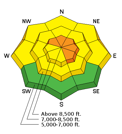
| type | aspect/elevation | characteristics |
|---|

|
|
LIKELIHOOD
 LIKELY
UNLIKELY
SIZE
 LARGE
SMALL
TREND
 INCREASING DANGER
SAME
DECREASING DANGER
|
|
description
Across the Logan Zone, wind slabs are forming today on weak preexisting snow. Heightened wind slab avalanche conditions already exist in exposed terrain at upper and mid elevations, and the danger will rise with continued snow and drifting from strong west winds. Dangerous conditions are likely to develop, with human triggered avalanches becoming likely on drifted upper elevation slopes.
|
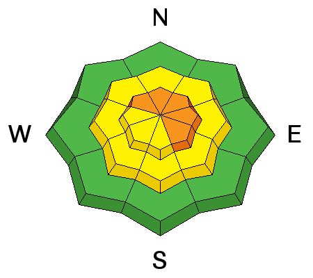
| type | aspect/elevation | characteristics |
|---|

|
|
LIKELIHOOD
LIKELY
UNLIKELY
SIZE
LARGE
SMALL
TREND
INCREASING DANGER
SAME
DECREASING DANGER
|
|
description
As the fresh Christmas snow stacks up on slopes plagued by very weak sugary or faceted snow, storm snow avalanches will be possible even in sheltered areas. The problem is, slopes might be subject to gradual loading in the next several days, and the slow increase in danger is liable to catch people off-guard.
|
 |
weather A series of weather systems will cross northern Utah this weekend into early next week.
|
| general announcements Don’t know what to buy your favorite skier for Christmas? Discount lift tickets for Alta, Snowbird, Brighton, Solitude, Deer Valley, Snowbasin, and Beaver Mountain are now available, donated by the resorts to benefit the Utah Avalanche Center. Details and order information here. These make a great holiday gift and all proceeds go towards paying for avalanche forecasting and education! Now is a great time to practice companion rescue techniques with your backcountry partners. Here's our rescue practice video. Go HERE for a list of UAC classes. EMAIL ADVISORY: If you would like to get the daily advisory by email you will need to subscribe here. Benefit the Utah Avalanche Center when you shop from Backcountry.com or REI: Click this link for Backcountry.com or this link to REI, shop, and they will donate a percent of your purchase price to the UAC. Both offer free shipping (with some conditions) so this costs you nothing! Benefit the Utah Avalanche Center when you buy or sell on ebay - set the Utah Avalanche Center as a favorite non-profit in your ebay account here and click on ebay gives when you buy or sell. You can choose to have your seller fees donated to the UAC, which doesn't cost you a penny. Remember your information can save lives. If you see anything we should know about, please help us out by submitting snow and avalanche observations. You can also call us at 801-524-5304, email by clicking HERE, or include #utavy in your tweet or Instagram. This advisory is from the U.S.D.A. Forest Service, which is solely responsible for its content. This advisory describes general avalanche conditions and local variations always occur. |


