25th Annual Black Diamond Fall Fundraising Party
Thursday, September 13; 6:00-10:00 PM; Black Diamond Parking Lot
25th Annual Black Diamond Fall Fundraising Party
Thursday, September 13; 6:00-10:00 PM; Black Diamond Parking Lot
| Advisory: Logan Area Mountains | Issued by Toby Weed for Wednesday - December 20, 2017 - 6:28am |
|---|

|
bottom line The avalanche danger will rise to CONSIDERABLE on some slopes in the backcountry with today's storm.
|
 |
special announcement Beaver Mountain opens up the lifts today, and you'll find great conditions. Don’t know what to buy your favorite skier for Christmas? Discount lift tickets for Alta, Snowbird, Brighton, Solitude, Deer Valley, Snowbasin, and Beaver Mountain are now available, donated by the resorts to benefit the Utah Avalanche Center. Details and order information here. These make a great holiday gift and all proceeds go towards paying for avalanche forecasting and education! Now is a great time to sign up for an avalanche class. Go HERE for a list of UAC classes. |
 |
current conditions It's mild and quite blustery in the mountains this morning in advance of a strong Pacific storm. The Tony Grove Snotel at 8400' reports 36°F and 26" total snow containing 83% of average SWE (Snow Water Equivalent). It's 29°F at the 9700' CSI Logan Peak weather station, and south winds picked up significantly overnight, currently blowing around 35 mph, and gusting to 58 mph. You'll need goggles today if you head up for opening day at Beaver Mountain, as snow is in the forecast all day. Snow and drifting from strong southwest and west winds will cause a rising avalanche danger in the backcountry, and dangerous conditions will develop on some slopes by evening.
|
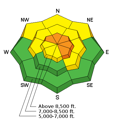
| type | aspect/elevation | characteristics |
|---|

|
|
LIKELIHOOD
 LIKELY
UNLIKELY
SIZE
 LARGE
SMALL
TREND
 INCREASING DANGER
SAME
DECREASING DANGER
|
|
description
An increase in south winds overnight created heightened wind slab avalanche conditions in exposed terrain this morning. Human triggered avalanches are possible in drifted upper and mid elevation terrain. The avalanche danger will rise and become more widespread during the day as a winter storm impacts the mountains and new snow stacks up on widespread weak preexisting snow. Drifting from strong southwest and westerly winds will rapidly build existing wind slabs and create new ones in exposed terrain. Dangerous wind slab avalanche conditions may develop by late afternoon, with human triggered avalanches becoming likely.
|
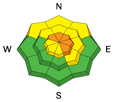
| type | aspect/elevation | characteristics |
|---|

|
|
LIKELIHOOD
 LIKELY
UNLIKELY
SIZE
LARGE
SMALL
TREND
INCREASING DANGER
SAME
DECREASING DANGER
|
|
description
More than expected snow will cause a heightened danger of storm slab avalanches. We've noticed and observers report increasing instances of localized shallow collapses and cracking. Very weak surface snow is widespread across the Logan Zone, and a layer consisting of very weak faceted snow directly above the solid Thanksgiving crust appears to be gradually getting weaker.
|
 |
weather The storm system over the Pacific Northwest will continue southeast into and then across Utah late this afternoon through Thursday. The associated cold front will enter northwest Utah this morning, then sweep southeast across the state by early Thursday. A second weather disturbance this weekend will bring additional cold air from Canada into the region.
|
| general announcements Now is a great time to practice companion rescue techniques with your backcountry partners. EMAIL ADVISORY: If you would like to get the daily advisory by email you will need to subscribe here. Benefit the Utah Avalanche Center when you shop from Backcountry.com or REI: Click this link for Backcountry.com or this link to REI, shop, and they will donate a percent of your purchase price to the UAC. Both offer free shipping (with some conditions) so this costs you nothing! Benefit the Utah Avalanche Center when you buy or sell on ebay - set the Utah Avalanche Center as a favorite non-profit in your ebay account here and click on ebay gives when you buy or sell. You can choose to have your seller fees donated to the UAC, which doesn't cost you a penny. Remember your information can save lives. If you see anything we should know about, please help us out by submitting snow and avalanche conditions. You can also call us at 801-524-5304, email by clicking HERE, or include #utavy in your tweet or Instagram. This advisory is from the U.S.D.A. Forest Service, which is solely responsible for its content. This advisory describes general avalanche conditions and local variations always occur. |


