25th Annual Black Diamond Fall Fundraising Party
Thursday, September 13; 6:00-10:00 PM; Black Diamond Parking Lot
25th Annual Black Diamond Fall Fundraising Party
Thursday, September 13; 6:00-10:00 PM; Black Diamond Parking Lot
| Advisory: Logan Area Mountains | Issued by Toby Weed for Wednesday - December 13, 2017 - 6:59am |
|---|

|
bottom line Backcountry snow is mostly stable, avalanches are unlikely, and the danger is LOW. Use normal caution.
|
 |
special announcement Don’t know what to buy your favorite skier for Christmas? Discount lift tickets for Alta, Snowbird, Brighton, Solitude, Deer Valley, Snowbasin,and Beaver Mountain are now available, donated by the resorts to benefit the Utah Avalanche Center. Details and order information here. These make a great holiday gift and all proceeds go towards paying for avalanche forecasting and education! Now is a great time to sign up for an avalanche class. Go HERE for a list of UAC classes. |
 |
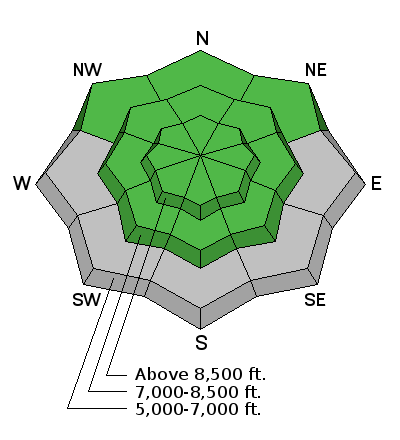
current conditions The Tony Grove Snotel at 8400' reports 32°F and 26" of total snow containing 99% of average SWE (Snow Water Equivalent). It's 29°F at the 9700' CSI Logan Peak weather station, with west wind currently blowing around 20 mph. Incessant northwest wind and warmth conspired to make snow surface conditions quite variable, but you can still might find some soft and fast recrystallized snow in sheltered terrain. There is more total snow and better coverage in the central and northern Bear River Range and at upper elevations. Shallow early season snow conditions exist, and hitting rocks or stumps is a significant hazard. Travel cautiously and keep your speed down. The Tony Grove Road is not maintained for wheeled travel in the winter.
Weak surface snow develops during periods of high pressure. Feathery surface hoar is actually frost growing on the snow surface (12-11-17). |
 |
recent activity No new avalanches were reported in the past week. A natural avalanche cycle occurred at upper elevations during the intense storm on 12/3/17. |
| type | aspect/elevation | characteristics |
|---|

|

|
LIKELIHOOD
 LIKELY
UNLIKELY
SIZE
 LARGE
SMALL
TREND
 INCREASING DANGER
SAME
DECREASING DANGER
|
|
description
It's a great time to get up into the mountains and above the stagnant air and low clouds. The air is clean, temperatures are warm, backcountry snow is mostly stable, and travel is fairly easy on supportable snow. With rather meager snow conditions and nice weather in the mountains, now is a great time to practice companion rescue techniques with your backcountry partners. |
| type | aspect/elevation | characteristics |
|---|

|
|
LIKELIHOOD
LIKELY
UNLIKELY
SIZE
LARGE
SMALL
TREND
 INCREASING DANGER
SAME
DECREASING DANGER
|
|
description
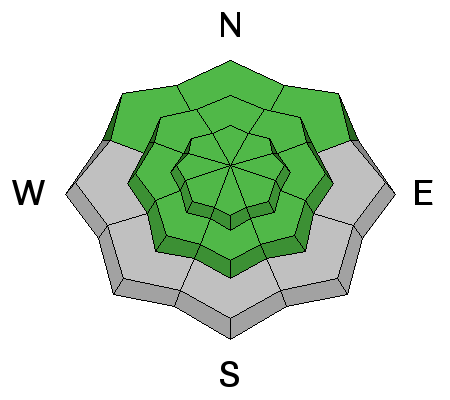
Despite a Low avalanche danger, wind slab avalanches are possible on some drifted upper elevation slopes. Wind slabs can be chalky looking and may be hollow sounding. Hard wind slabs are supportable and sometimes let a person get well out on them before releasing. Use caution and avoid drifts in steep terrain near ridges and in and around terrain features like gullies, saddles, rock bands, scoops, and sub-ridges.
|
 |
weather The ridge of high pressure responsible for the recent dry weather and valley fog is slowly sliding westward off the California coast and this will allow a northwest flow aloft to overspread the region. A rather weak shortwave will dig southward this afternoon through tonight, bringing a slight chance for snow to the higher terrain of the Uintas as well as perhaps the Bear River Range. An inch or two of snow is possible in the Logan Zone at upper elevations near the Idaho State Line. Forecast models are now in agreement that a stronger short wave will impact the region Friday night into Saturday. This system will most likely be strong enough to scour the cold stagnant air out of the valleys, but does not appear to bring much in the way of accumulating snow to the mountains of Utah. Even so, some snow is likely to fall at upper elevations in the Logan Zone on Saturday. Another system looks to be on tap for the middle of next week. |
| general announcements EMAIL ADVISORY: If you would like to get the daily advisory by email you will need to subscribe here. Benefit the Utah Avalanche Center when you shop from Backcountry.com or REI: Click this link for Backcountry.com or this link to REI, shop, and they will donate a percent of your purchase price to the UAC. Both offer free shipping (with some conditions) so this costs you nothing! Benefit the Utah Avalanche Center when you buy or sell on ebay - set the Utah Avalanche Center as a favorite non-profit in your ebay account here and click on ebay gives when you buy or sell. You can choose to have your seller fees donated to the UAC, which doesn't cost you a penny. Remember your information can save lives. If you see anything we should know about, please help us out by submitting snow and avalanche conditions. You can also call us at 801-524-5304, email by clicking HERE, or include #utavy in your tweet or Instagram. This advisory is from the U.S.D.A. Forest Service, which is solely responsible for its content. This advisory describes general avalanche conditions and local variations always occur. |