25th Annual Black Diamond Fall Fundraising Party
Thursday, September 13; 6:00-10:00 PM; Black Diamond Parking Lot
25th Annual Black Diamond Fall Fundraising Party
Thursday, September 13; 6:00-10:00 PM; Black Diamond Parking Lot
| Advisory: Logan Area Mountains | Issued by Toby Weed for Thursday - December 7, 2017 - 7:10am |
|---|

|
bottom line Heightened avalanche conditions exist on upper and mid elevation slopes in the backcountry. Human triggered persistent and wind slab avalanches are possible and most likely in drifted upper elevation terrain. Evaluate snow and terrain carefully.
|
 |
special announcement Please join us for our 14th annual "Pray for Snow" fundraiser/party, TONIGHT at 6 PM. This year's new location is at the new Cache Venue, 119 South Main St in downtown Logan. Go HERE for advance tickets and more information. Don’t know what to buy your favorite skier for Christmas? Discount lift tickets for Alta, Snowbird, Brighton, Solitude, Deer Valley, Snowbasin,and Beaver Mountain are now available, donated by the resorts to benefit the Utah Avalanche Center. Details and order information here. These make a great holiday gift and all proceeds go towards paying for avalanche forecasting and education! |
 |
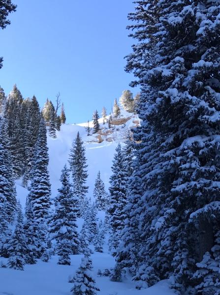
current conditions The Tony Grove Snotel at 8400' reports 16°F and 32" of total snow containing 114% of average SWE (Snow Water Equivalent). It's 10°F at 9700' at the CSI Logan Peak weather station, with northwest wind currently blowing 19 mph, with gusts to 34 mph. Folks are finding very nice powder riding conditions this week in the Logan Zone, with more total snow and better coverage in the central and northern sections and at upper elevations. Heightened avalanche conditions exist at upper and mid elevations, with human triggered avalanches possible. Just beneath the fresh powder, shallow early season snow conditions exist, and hitting rocks or stumps is a significant hazard. Travel cautiously and keep your speed down. The Tony Grove Road is not maintained for wheeled travel in the winter. |
 |
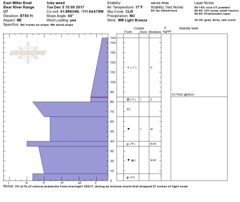
recent activity With clearing Tuesday we could see evidence of a fairly widespread natural avalanche cycle that occurred in the Central Bear River Range during the intense storm Sunday night (12/3/17), which deposited 27" at the Tony Grove Snotel. The storm slab avalanches on north through east facing slopes above around 8200' ranged from 40' to 200' in width and were all about 2' deep. The avalanches failed on a layer of sugary faceted snow and/or feathery surface hoar above the stout Thanksgiving crust. -We also received an Instagram report of a good sized avalanche seen above the warming shack in upper Boss Canyon on 12/4/17.
Jensen (12/5/17) |
| type | aspect/elevation | characteristics |
|---|

|
|
LIKELIHOOD
 LIKELY
UNLIKELY
SIZE
 LARGE
SMALL
TREND
 INCREASING DANGER
SAME
DECREASING DANGER
|
|
description
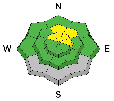
The widespread natural storm slab avalanches that occurred during the 12/3-12/4 storm failed on a thin layer consisting weak faceted or recrystallized snow and perhaps surface hoar above the solid Thanksgiving crust. Although it appeared that most suspect steep slopes naturally avalanched during the storm, triggered persistent slab avalanches are possible on steep slopes that did not.
|
| type | aspect/elevation | characteristics |
|---|

|
|
LIKELIHOOD
LIKELY
UNLIKELY
SIZE
LARGE
SMALL
TREND
 INCREASING DANGER
SAME
DECREASING DANGER
|
|
description
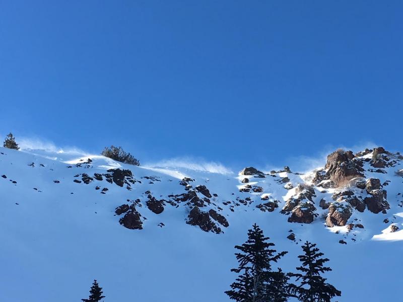
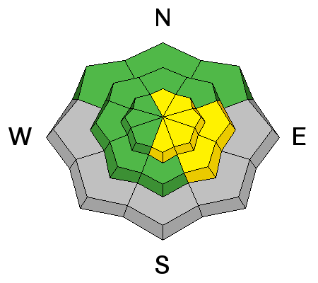
Monday's light powder snow was easily drifted into stiffer wind slabs by northwest wind in exposed terrain. Heightened wind slab avalanche conditions exist on drifted upper elevation slopes. Wind slabs can be chalky looking and may be hollow sounding. Soft wind slabs are often quite sensitive and easy to trigger, while hard wind slabs are supportable and sometimes let a person get well out on them before releasing. Avoid drifts near ridges and in and around terrain features like gullies, rock bands and sub-ridges.
Northwest winds drifted snow and created wind slabs at upper elevations yesterday. |
 |
weather Strong high pressure centered to the west of Utah will maintain a stable northerly flow across the Great Basin through the end of the week. Expect mostly sunny skies today, a high temperature at 8500' around 29°F, and 15 mph north-northwest wind. It'll be mostly clear tonight, with a low temperature around 14°F and 10 to 14 mph north-northwest wind. It'll be sunny tomorrow with a high near 35°F and 5 to 9 mph north-northwest wind becoming light from the west-northwest. |
| general announcements EMAIL ADVISORY: If you would like to get the daily advisory by email you will need to subscribe here. Benefit the Utah Avalanche Center when you shop from Backcountry.com or REI: Click this link for Backcountry.com or this link to REI, shop, and they will donate a percent of your purchase price to the UAC. Both offer free shipping (with some conditions) so this costs you nothing! Benefit the Utah Avalanche Center when you buy or sell on ebay - set the Utah Avalanche Center as a favorite non-profit in your ebay account here and click on ebay gives when you buy or sell. You can choose to have your seller fees donated to the UAC, which doesn't cost you a penny. Remember your information can save lives. If you see anything we should know about, please help us out by submitting snow and avalanche conditions. You can also call us at 801-524-5304, email by clicking HERE, or include #utavy in your tweet or Instagram. This advisory is from the U.S.D.A. Forest Service, which is solely responsible for its content. This advisory describes general avalanche conditions and local variations always occur. |