25th Annual Black Diamond Fall Fundraising Party
Thursday, September 13; 6:00-10:00 PM; Black Diamond Parking Lot
25th Annual Black Diamond Fall Fundraising Party
Thursday, September 13; 6:00-10:00 PM; Black Diamond Parking Lot
| Advisory: Logan Area Mountains | Issued by Toby Weed for Sunday - December 3, 2017 - 6:43am |
|---|

|
bottom line MODERATE: Today's storm will cause a rising avalanche danger in the backcountry. Human triggered avalanches are possible. Evaluate snow and terrain carefully, especially drifted upper elevation slopes.
|
 |
special announcement Please join us for our 14th annual "Pray for Snow" fundraiser/party, Thursday, December 7 at 6 PM. This year's new location is at the new Cache Venue, 119 South Main St in downtown Logan. Go HERE for advance tickets and more information. |
 |
current conditions The Tony Grove Snotel at 8400' reports and 37°F this morning. There's 18" of total snow containing 100% of average SWE (Snow Water Equivalent). It's 29°F at 9700' on Logan Peak at the CSI weather station, with a strong south wind currently blowing 36 mph and gusting to 53 mph. Record warmth around Thanksgiving melted a good deal of snow across the zone, and a solid refreeze this week turned the remaining snow rock hard. There is 2 to 3 feet of hard snow on upper elevation slopes in the central and northern parts of the Bear River Range and much less to the south and in the Wellsville Range. Observers found variable surface conditions with an inch of new snow and pockets of smooth dust-on-crust at upper elevations yesterday. Shallow, early season snow conditions exist, and hitting rocks or stumps is a significant hazard. Travel cautiously and keep your speed down. The Tony Grove Road is not maintained for wheeled travel in the winter.
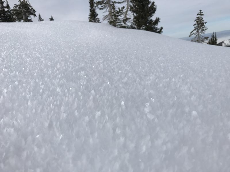
The snow surface at upper elevations yesterday was sparkling with widespread feathery surface hoar or frost crystals. Surface hoar often becomes a tricky persistent weak layer once buried. (Jensen, 12/2/17) |
| type | aspect/elevation | characteristics |
|---|

|
|
LIKELIHOOD
 LIKELY
UNLIKELY
SIZE
 LARGE
SMALL
TREND
 INCREASING DANGER
SAME
DECREASING DANGER
|
|
description
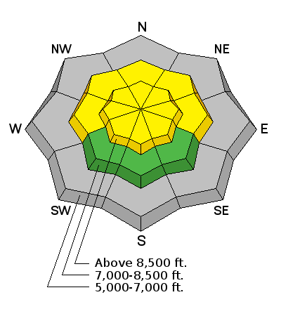
Strong prefrontal winds this morning are already drifting snow into upper elevation avalanche starting zones, and shallow triggered wind slab avalanches are possible on steep drifted slopes. Heightened avalanche danger will continue to rise as drifting continues and increases today and overnight.
|
| type | aspect/elevation | characteristics |
|---|

|
|
LIKELIHOOD
LIKELY
UNLIKELY
SIZE
 LARGE
SMALL
TREND
INCREASING DANGER
SAME
DECREASING DANGER
|
|
description
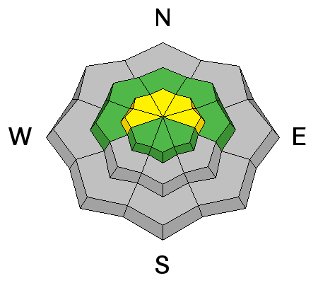
Heavy snowfall could cause a heightened danger of storm slab avalanches to develop later today. The fresh new snow may not bond well to the hard Thanksgiving snow surface especially on slopes where the current soft surface snow is weak, recrystallized or covered by glittery surface hoar. It may become possible to trigger avalanches remotely or from a distance. Storm snow avalanches could be fairly wide and might run fast and far on the slick underlying snow. |
 |
weather The National Weather Service has issued a Winter Weather Advisory for the mountains of northern Utah. A cold Pacific storm system will reach Utah this afternoon. The associated strong cold front will bring rain changing to snow to mainly northern Utah, with much colder temperatures statewide. High pressure aloft will build into the area again early next week. Snow should begin falling this morning and continue through tonight, with 8 to 14 inches possible in the mountains by tomorrow morning. Temperatures at 8500' should drop to around 23°F this afternoon and southwest winds will blow 20 to 22 mph. Blizzard conditions will occur in the mountains tonight, with heavy snow and wind chill values as low as -4°F . Temperatures will drop to 14°F and it'll be quite windy, with 20 to 30 mph northwest wind and much higher gusts. Expect diminishing snow showers and mostly cloudy conditions tomorrow, with a high temperature around 17°F and 9 to 17 mph northwest wind. |
| general announcements We are offering a Backcountry 101 Avalanche Class on December 12 and 14 in the Logan Area Backcountry. EMAIL ADVISORY: If you would like to get the daily advisory by email you will need to subscribe here. Benefit the Utah Avalanche Center when you shop from Backcountry.com or REI: Click this link for Backcountry.com or this link to REI, shop, and they will donate a percent of your purchase price to the UAC. Both offer free shipping (with some conditions) so this costs you nothing! Benefit the Utah Avalanche Center when you buy or sell on ebay - set the Utah Avalanche Center as a favorite non-profit in your ebay account here and click on ebay gives when you buy or sell. You can choose to have your seller fees donated to the UAC, which doesn't cost you a penny. Remember your information can save lives. If you see anything we should know about, please help us out by submitting snow and avalanche conditions. You can also call us at 801-524-5304, email by clicking HERE, or include #utavy in your tweet or Instagram. This advisory is from the U.S.D.A. Forest Service, which is solely responsible for its content. This advisory describes general avalanche conditions and local variations always occur. |