25th Annual Black Diamond Fall Fundraising Party
Thursday, September 13; 6:00-10:00 PM; Black Diamond Parking Lot
25th Annual Black Diamond Fall Fundraising Party
Thursday, September 13; 6:00-10:00 PM; Black Diamond Parking Lot
| Advisory: Logan Area Mountains | Issued by Toby Weed for Friday - November 24, 2017 - 7:10am |
|---|

|
bottom line LOW: Backcountry snow is mostly stable and avalanches are unlikely. Shallow, early season snow conditions exist. Use normal caution.
|
 |
special avalanche bulletin Please join us for our 14 annual "Pray for Snow" fundraiser/party, Thursday, December 7 at 6 PM. This year's new location is at the new Cache Venue, 119 South Main St in downtown Logan. Go HERE for advance tickets and more information. |
 |
current conditions The Tony Grove Snotel at 8400' reports 40°F this morning and 18" of total snow containing 135% of average SWE (Snow Water Equivalent). Temperatures again stayed well above freezing overnight, with 35°F this morning at 9700' CSI Logan Peak and 42°F at UDOT Hwy 89 Logan Summit. Cloud cover and a stiff westerly breeze should slow the melt and help keep the snow surface cooled off today. Shallow, early season snow conditions exist, and hitting rocks or stumps is a significant hazard. Travel cautiously and keep your speed down. The Tony Grove Road is not maintained for wheeled travel in the winter, so if you venture up, have all the needed gear, be patient and ready to dig. |
 |
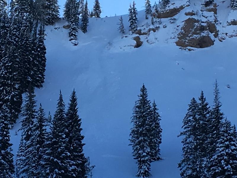
recent activity Evidence of a small wind slab avalanche was visible on Sunday in East Miller Bowl south of Tony Grove Lake. I think this was a natural from during Friday's storm, but there were some ski and board tracks nearby.
Small wind slab avalanche in East Miller Bowl, 11/19/17 |
| type | aspect/elevation | characteristics |
|---|

|
|
LIKELIHOOD
 LIKELY
UNLIKELY
SIZE
 LARGE
SMALL
TREND
 INCREASING DANGER
SAME
DECREASING DANGER
|
|
description
Warmth and rain in the past couple days melted a good deal of snow and created some potential for shallow wet avalanches in steep terrain. Clouds, wind, and cooler temperatures will slow the melt limit the danger of loose wet avalanches today. The remaining snow on most slopes is stable, and avalanches are unlikely. Even so, a ride in even a small avalanche could be particularly dangerous due to potential for being raked through rocks or deadfall below. |
 |
weather A fast moving but weak weather disturbance will cross northern Utah this afternoon. Strong high pressure aloft will return this weekend, followed by a storm system early next week. Snow is likely this afternoon, with an inch of accumulation possible. Expect cloudy skies, with a high temperature at 8500' around 40°F and 17 to 21 mph west wind. Snow showers will continue this evening. Tonight will be mostly cloudy, with temperatures dropping to around 29°F and 13 to 18 mph west wind. Saturday will be partly sunny, with high temperatures around 45°F and 10 to 15 mph west wind. |
| general announcements We are offering a Backcountry 101 Avalanche Class on December 12 and 14 in the Logan Area Backcountry. EMAIL ADVISORY: If you would like to get the daily advisory by email you will need to subscribe here. Benefit the Utah Avalanche Center when you shop from Backcountry.com or REI: Click this link for Backcountry.com or this link to REI, shop, and they will donate a percent of your purchase price to the UAC. Both offer free shipping (with some conditions) so this costs you nothing! Benefit the Utah Avalanche Center when you buy or sell on ebay - set the Utah Avalanche Center as a favorite non-profit in your ebay account here and click on ebay gives when you buy or sell. You can choose to have your seller fees donated to the UAC, which doesn't cost you a penny. Remember your information can save lives. If you see anything we should know about, please help us out by submitting snow and avalanche conditions. You can also call us at 801-524-5304, email by clicking HERE, or include #utavy in your tweet or Instagram. This advisory is from the U.S.D.A. Forest Service, which is solely responsible for its content. This advisory describes general avalanche conditions and local variations always occur. |