25th Annual Black Diamond Fall Fundraising Party
Thursday, September 13; 6:00-10:00 PM; Black Diamond Parking Lot
25th Annual Black Diamond Fall Fundraising Party
Thursday, September 13; 6:00-10:00 PM; Black Diamond Parking Lot
| Advisory: Logan Area Mountains | Issued by Toby Weed for Saturday - November 18, 2017 - 7:26am |
|---|

|
bottom line There's a CONSIDERABLE danger on some drifted upper elevation slopes facing north, where you are likely to trigger a dangerous avalanche. Heightened avalanche conditions exist on many other upper and mid elevation slopes. Triggered persistent and wind slab avalanches up to about 2' deep are possible. A ride in even a small avalanche could be particularly dangerous due to potential for being raked through rocks or deadfall below. Avoid travel in drifted upper elevation terrain.
|
 |
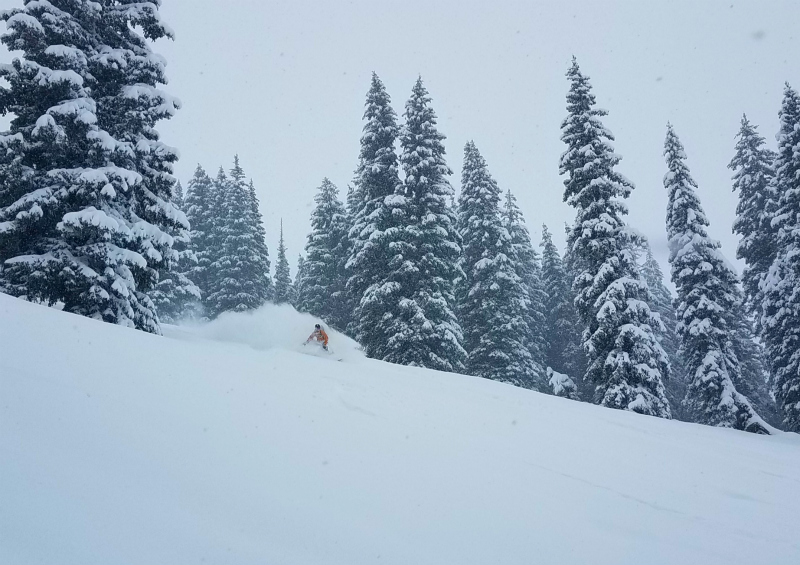
current conditions Heightened avalanche conditions exist at upper elevations, and human triggered avalanches are possible on steep drifted slopes. In shallow snow conditions the risk of injury is significantly increased. If you were to get caught in even a small avalanche, you risk being raked through rocks and deadfall below. The Tony Grove Snotel at 8400' reports 16" of new snow with 2.8" SWE (Snow Water Equivalent) in the last 48 hours. It's 16°F this morning, and there's now 28" total settled snow. Last night's winds were out of the northwest, with UDOT Hwy 89 Summit showing sustained 15 mph hourly averages with gusts in the 30s Both Logan and Ogden Peak wind sensors are encased in rime (ice). Shallow, early season snow conditions exist, and hitting rocks or down and dead wood presents a significant hazard. Travel cautiously and keep your speed down. The Tony Grove Road is not maintained for wheeled travel in the winter, so if you venture up, have all the needed gear, be patient and be ready to dig. Some folks found pretty good powder riding conditions near Tony Grove Lake yesterday. |
| type | aspect/elevation | characteristics |
|---|

|
|
LIKELIHOOD
 LIKELY
UNLIKELY
SIZE
 LARGE
SMALL
TREND
 INCREASING DANGER
SAME
DECREASING DANGER
|
|
description
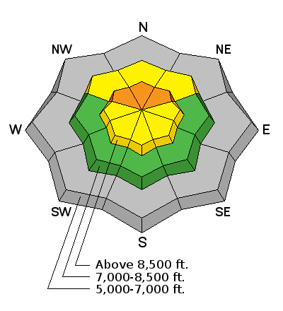
Upper elevation slopes in the Bear River Range picked up significant heavy snow with sustained westerly wind. Heightened avalanche conditions exist and triggered persistent slab avalanches are possible on drifted upper elevation slopes with weak preexisting snow. More dangerous conditions likely exist at the highest elevations where deep drifts formed and pockets of old faceted snow from September are holding out. In these areas, triggered avalanches are likely. |
| type | aspect/elevation | characteristics |
|---|

|
|
LIKELIHOOD
LIKELY
UNLIKELY
SIZE
LARGE
SMALL
TREND
 INCREASING DANGER
SAME
DECREASING DANGER
|
|
description
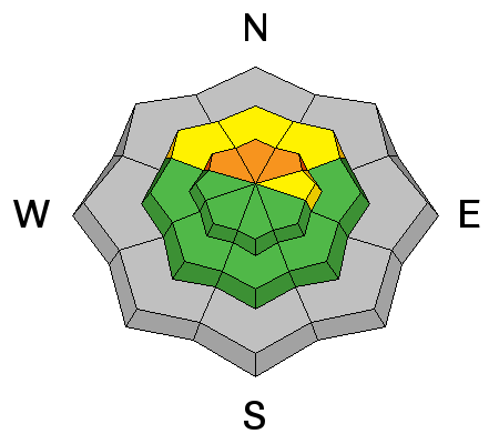
Drifting snow caused heightened danger of wind slab avalanches in exposed upper elevation terrain this weekend. Watch for and avoid stiffer drifts near ridges and in and around terrain features like rock outcrops, sub-ridges, scoops, and gullies. |
 |
weather High pressure will build across the region over the weekend. A weak weather disturbance will graze northern Utah Monday night, followed by strong high pressure aloft returning midweek. |