25th Annual Black Diamond Fall Fundraising Party
Thursday, September 13; 6:00-10:00 PM; Black Diamond Parking Lot
25th Annual Black Diamond Fall Fundraising Party
Thursday, September 13; 6:00-10:00 PM; Black Diamond Parking Lot
| Advisory: Logan Area Mountains | Issued by Toby Weed for Tuesday - April 18, 2017 - 8:10am |
|---|

|
bottom line Evaluate snow and terrain carefully.
|
 |
special announcement Great news… so far there haven’t been any avalanche fatalities in Utah this winter! It has been 26 years since we’ve had a fatality-free winter. Let’s keep it that way and stay safe this spring. Our goal is for everyone to enjoy the Greatest Snow on Earth and come home safe every day. The final regular advisory will be this Sunday, April 16. For the rest of the month we'll issue updates when conditions change significantly; however, we will discontinue issuing regular advisories and avalanche danger ratings after Sunday. |
 |
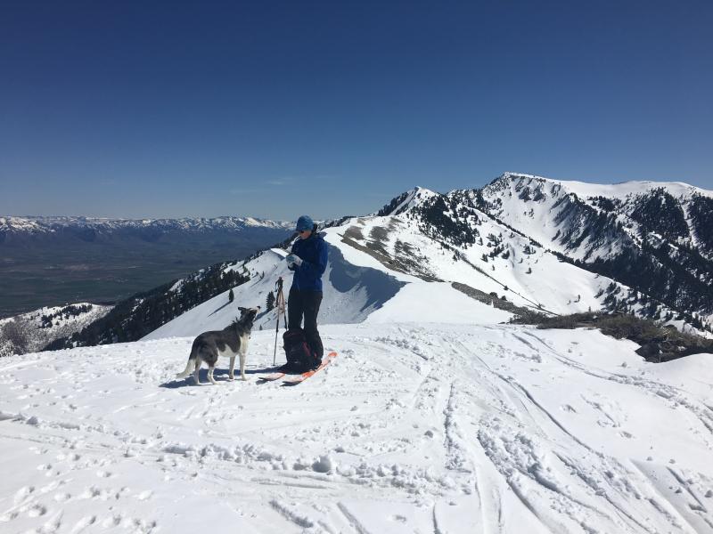
current conditions The Tony Grove Snotel at 8400' reports 30 °F and 99" of total snow, with 154% of average SWE (Snow Water Equivalent). A 15 mph southwest wind is blowing and it's 27 °F at the 9700' CSI Logan Peak weather station. High angled spring sun will quickly soften the snow surface, and heightened wet avalanche conditions will develop in sunny terrain due to wamth.
Yesterday was a good day for spring snow conditions in the Wellsville Mountain Wilderness. |
 |
recent activity Although we will be shutting down regular operations, we will continue to post recent avalanche activity and observations through the end of the month as we receive them, so please do continue to send them to us. You can check the latest observations here. We also follow avalanche-related activity on Instagram - be sure to tag your photos with #utavy . |
| type | aspect/elevation | characteristics |
|---|

|

|
LIKELIHOOD
 LIKELY
UNLIKELY
SIZE
 LARGE
SMALL
TREND
 INCREASING DANGER
SAME
DECREASING DANGER
|
|
description
As you travel in the mountains, keep a few things in mind:
|
| type | aspect/elevation | characteristics |
|---|---|---|

|
|
LIKELIHOOD
LIKELY
UNLIKELY
SIZE
LARGE
SMALL
TREND
INCREASING DANGER
SAME
DECREASING DANGER
|
description
|
| type | aspect/elevation | characteristics |
|---|

|

|
LIKELIHOOD
 LIKELY
UNLIKELY
SIZE
 LARGE
SMALL
TREND
 INCREASING DANGER
SAME
DECREASING DANGER
|
|
description
We almost always get several winter-like snow storms in April and May. Treat each storm just like you would in winter. Avalanches can occur within the new snow typically from 1) low density layers deposited during the storm, 2) high precipitation intensity during a storm and 3) from wind slabs created during the storm. It's easy to test the new snow as you travel by jumping on small test slopes to see if they avalanche or just dig down with your hand to see how well the new snow is bonding. Snow can change dramatically in both space and time so never let your guard down. Especially avoid any steep slope with recent wind deposits, which are almost always dangerous. |
 |
weather |
| general announcements Do you buy groceries at Smiths? When you register your Smith’s rewards card with their Community Rewards program, they will donate to the Utah Avalanche Center whenever you make a purchase. It's easy, only takes a minute, and doesn't cost you anything. Details here. If you sign up for AmazonSmile and designate the Utah Avalanche Center as your favorite charity, they will donate a portion of everything you spend to the UAC. It doesn't cost you a penny and we'd really appreciate the help. Your information can save lives. If you see anything we should know please help us out by submitting snow and avalanche observations. You can call us at 801-524-5304, email by clicking HERE, or include @utavy in your Instagram. In the Logan Area you can reach me at 435-757-7578 This advisory is from the U.S.D.A. Forest Service, which is solely responsible for its content. This advisory describes general avalanche conditions and local variations always exist. |