25th Annual Black Diamond Fall Fundraising Party
Thursday, September 13; 6:00-10:00 PM; Black Diamond Parking Lot
25th Annual Black Diamond Fall Fundraising Party
Thursday, September 13; 6:00-10:00 PM; Black Diamond Parking Lot
| Advisory: Logan Area Mountains | Issued by Toby Weed for Saturday - April 15, 2017 - 6:21am |
|---|

|
bottom line After a clear and cold night, backcountry snow is hard and stable. The avalanche danger is LOW. Use normal caution.
|
 |
special announcement Great news… so far there haven’t been any avalanche fatalities in Utah this winter! It has been 26 years since we’ve had a fatality-free winter. Let’s keep it that way and stay safe this spring. Our goal is for everyone to enjoy the Greatest Snow on Earth and come home safe every day. The final regular advisory will be this Sunday, April 16. For the rest of the month we'll issue updates when conditions change significantly; however, we will discontinue issuing regular advisories and avalanche danger ratings after Sunday. |
 |
current conditions Backcountry snow is hard and stable after a cold clear night. The Tony Grove Snotel reports an inch or two of new snow and 20 °F this morning. At 8400' there's 100" of total snow, with 154% of average SWE (Snow Water Equivalent). A 12 mph west wind is blowing and it's 10 °F at the 9700' CSI Logan Peak weather station. High angled spring sun will soften the snow surface, and there will be nice smooth "corn snow" conditions on many slopes by late morning. |
 |
recent activity
|
| type | aspect/elevation | characteristics |
|---|

|
|
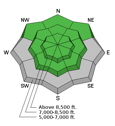
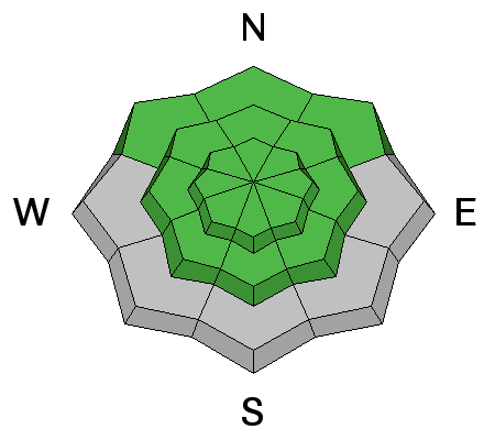
LIKELIHOOD
 LIKELY
UNLIKELY
SIZE
 LARGE
SMALL
TREND
 INCREASING DANGER
SAME
DECREASING DANGER
|
|
description
Colder temperatures are helping to increase the stability of the springtime snow but, as you travel in the mountains, keep a few things in mind:
|
 |
weather A cool but dry air-mass will remain in place today. It will be warmer on Sunday ahead of the next weather disturbance, which will affect the weather on Monday. It will be sunny today, with a high temperature at 8500' of 36 °F and 5 to 14 mph northwest wind. Tonight will be mostly clear, a low temperature of 28 °F and 5 to 7 mph west wind. Sunday will be partly sunny, a high temperature of 48 °F and 5 to 10 mph southwest wind. |
| general announcements Do you buy groceries at Smiths? When you register your Smith’s rewards card with their Community Rewards program, they will donate to the Utah Avalanche Center whenever you make a purchase. It's easy, only takes a minute, and doesn't cost you anything. Details here. If you sign up for AmazonSmile and designate the Utah Avalanche Center as your favorite charity, they will donate a portion of everything you spend to the UAC. It doesn't cost you a penny and we'd really appreciate the help. Your information can save lives. If you see anything we should know please help us out by submitting snow and avalanche observations. You can call us at 801-524-5304, email by clicking HERE, or include @utavy in your Instagram. In the Logan Area you can reach me at 435-757-7578 This advisory is from the U.S.D.A. Forest Service, which is solely responsible for its content. This advisory describes general avalanche conditions and local variations always exist. |


