25th Annual Black Diamond Fall Fundraising Party
Thursday, September 13; 6:00-10:00 PM; Black Diamond Parking Lot
25th Annual Black Diamond Fall Fundraising Party
Thursday, September 13; 6:00-10:00 PM; Black Diamond Parking Lot
| Advisory: Logan Area Mountains | Issued by Paige Pagnucco for Wednesday - April 12, 2017 - 6:36am |
|---|

|
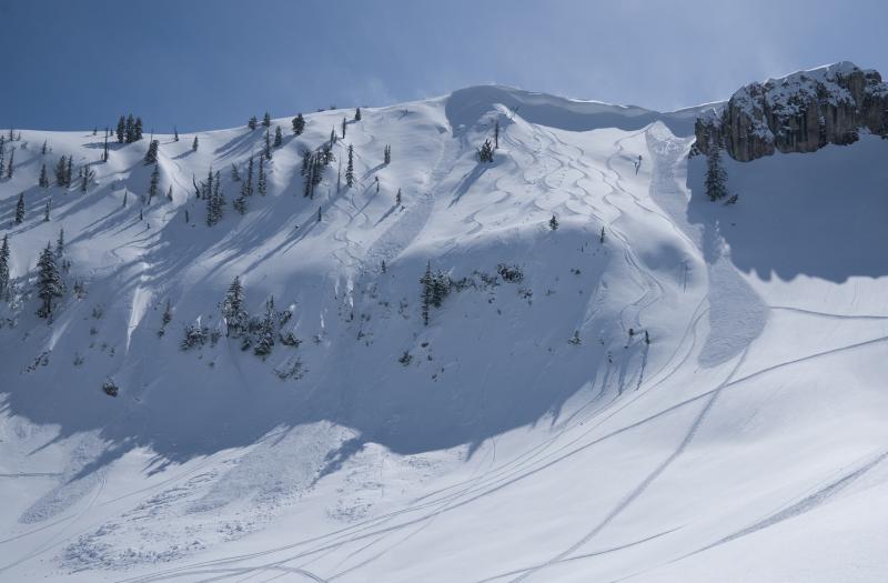
bottom line The avalanche danger is MODERATE and heightened avalanche conditions exist. Evaluate terrain and snow carefully. Loose wet snow avalanches entraining saturated fresh snow are likely with seasonal warming on steep mid and upper elevation slopes. Avoid being on or under cornices as they may break back further than expected.
|
 |
special announcement Garage Sale! Want to stand on one of Utah's high peaks this spring? Are you thinking of hiring a guide? We are selling a gift certificate donated by Utah Mountain Adventures for a day of private guiding for two people. Selling for $250. We also have a pair of Black Diamond Helio 116 size 176cm skis that we are selling for $600 All proceeds benefit the Utah Avalanche center. If you are interested in purchasing or have questions please contact[email protected] |
 |
current conditions The Tony Grove Snotel reports 33 °F and there's 103" of total snow, with 154% of average SWE (Snow Water Equivalent) at 8400'. Southerly winds are blowing 15-20 mph and it's 30 °F at the 9700' CSI Logan Peak weather station. Snow surfaces are a mix of crusts of varying thickness and settled damp snow ranging from 8-12". Without a deep refreeze overnight, today's snow will start out damp and get wetter quickly as temperatures increase. Snowmobiling conditions are excellent right now. Skiing conditions, not so much. To avoid avalanche issues today, get out early and go home early. When you see signs of increasing instability, like rollerballs or pinwheels, it is time to move to lower angle terrain. |
 |
recent activity Observers reported widespread triggered wind slab acitvity on Monday at high elevations. There also appears to have been a natural cycle that occurred over the weekend during the storm.
Monday's wind slab avalanches. (pc: J. Jensen) (pc: E. Flygare) There was loose wet activity on warming slopes both Monday and Tuesday.
|
| type | aspect/elevation | characteristics |
|---|

|
|
LIKELIHOOD
 LIKELY
UNLIKELY
SIZE
 LARGE
SMALL
TREND
 INCREASING DANGER
SAME
DECREASING DANGER
|
|
description
Wet loose avalanches involving moist fresh snow are possible on steep slopes at upper and mid elevations. At this time of the year, the effects of heating can change the snow in mere minutes. Today will be warmer than yesterday and, coupled with a poor overnight refreeze, loose wet activity will happen quickly once it starts heating up.
|
| type | aspect/elevation | characteristics |
|---|

|
|
LIKELIHOOD
LIKELY
UNLIKELY
SIZE
LARGE
SMALL
TREND
INCREASING DANGER
SAME
DECREASING DANGER
|
|
description
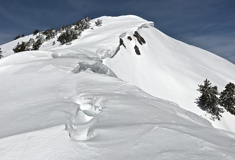
Avoid being on or below large ridge-top cornices.
Large ridge-top cornices in the Logan zone are buckling and calving during the spring meltdown. (pc: C.Titensor 4/5/17) |
 |
weather It is April indeed! Another very warm day is on tap for the mountains with temperatures forecast to reach 50+F at 8800'. Winds will be out of the southwest blowing 10-15 mph with stronger gusts possible. The warm southwest flow will continue tomorrow with gusty winds ahead of a cold front that will cross Utah late Thursday through Thursday night. The mountains will see rain and snow through Friday night with little accumulation expected. |
| general announcements Discount lift tickets for Beaver Mountain, Snowbasin, Powder Mountain, and the Central Wasatch resorts are donated by the resorts to benefit the Utah Avalanche Center. Details and order information here. Do you buy groceries at Smiths? When you register your Smith’s rewards card with their Community Rewards program, they will donate to the Utah Avalanche Center whenever you make a purchase. It's easy, only takes a minute, and doesn't cost you anything. Details here. If you sign up for AmazonSmile and designate the Utah Avalanche Center as your favorite charity, they will donate a portion of everything you spend to the UAC. It doesn't cost you a penny and we'd really appreciate the help. Your information can save lives. If you see anything we should know please help us out by submitting snow and avalanche observations. You can call us at 801-524-5304, email by clicking HERE, or include @utavy in your Instagram. In the Logan Area you can reach me at 435-757-7578 We will update this advisory regularly on Monday, Wednesday, Friday, and Saturday mornings by about 7:30. This advisory is from the U.S.D.A. Forest Service, which is solely responsible for its content. This advisory describes general avalanche conditions and local variations always exist. |


.jpg)