25th Annual Black Diamond Fall Fundraising Party
Thursday, September 13; 6:00-10:00 PM; Black Diamond Parking Lot
25th Annual Black Diamond Fall Fundraising Party
Thursday, September 13; 6:00-10:00 PM; Black Diamond Parking Lot
| Advisory: Logan Area Mountains | Issued by Toby Weed for Friday - April 7, 2017 - 7:10am |
|---|

|
bottom line After a warm night, heightened wet avalanche conditions may develop in steep terrain during the heat of the day. A strong and windy Pacific storm will cause increasing avalanche danger in the backcountry this weekend. Evaluate snow and terrain carefully.
|
 |
special announcement UAC Gear Sale Fundraiser: We still have some donated gear and certificates left over from the season. Want a guided rock climbing or canyoneering trip in Moab? How about a new pair of skis for some spring ski missions? Check out our gear sale photo album to see if we have what you need. This is a fundraising sale for the Utah Avalanche Center. All proceeds benefit avalanche forecasting and education. Click here to visit the sale! |
 |
current conditions Last night was cloudy, windy and warm, with temperatures well above freezing all stations this morning. The Tony Grove Snotel reports 44 °F and there's 100" of total snow, with 146% of average SWE (Snow Water Equivalent) at 8400'. It's 37 °F at the 9700' CSI Logan Peak weather station and a 34 mph south-southeast wind is howling along the ridges, gusting to 62 mph overnight. After a balmy night, temperatures will climb into the 50s today, and heat-related or wet avalanche activity is possible in steep terrain. Snow and wind from a powerful Pacific storm will create heightened danger in the backcountry over the weekend.
Sunset in the Central Bear River Range. 4/5/17 |
 |
recent activity Other than expected and minor wet loose activity, no backcountry avalanches were reported in the Logan Zone in the last week. |
| type | aspect/elevation | characteristics |
|---|

|
|
LIKELIHOOD
 LIKELY
UNLIKELY
SIZE
 LARGE
SMALL
TREND
 INCREASING DANGER
SAME
DECREASING DANGER
|
|
description
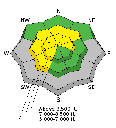
Wet avalanches are possible with midday warmth on steep slopes at upper and mid elevations.
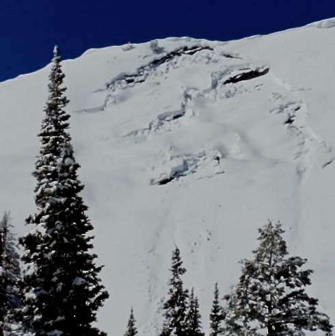
Jon Rosine sent in this picture of a glide avalanche on Wilderness Peak, north of the state line in Franklin Basin. 4/1/17 |
| type | aspect/elevation | characteristics |
|---|

|
|
LIKELIHOOD
LIKELY
UNLIKELY
SIZE
LARGE
SMALL
TREND
INCREASING DANGER
SAME
DECREASING DANGER
|
|
description
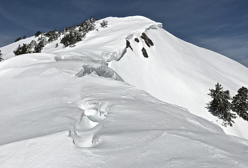
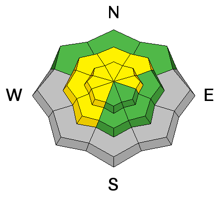
Avoid being on or below large ridge-top cornices.
Large ridge-top cornices in the Logan Zone are buckling and calving during the Spring meltdown. C.Titensor 4/5/17 |
 |
weather A cold upper level trough over the eastern Pacific will advance across the Great Basin this weekend. Windy and warm conditions ahead of the trough will give way to much colder and wet conditions this weekend. Today will be mostly cloudy with a chance of rain and thunder showers. Temperature at 8500' will reach 51 °F. It will be windy, with 23 to 33 mph southwest wind gusting to 50 mph. Rain, snow and thunder showers are likely tonight, with a low temperature of 31 °F, 28 to 33 mph southwest wind, gusting to 50 mph and 3 to 5 inches of snow possible. Snow will continue tomorrow, with a high temperature of 37 °F and 16 to 21 mph northwest wind, veering from the east midday. 8 to 16 inches of additional new snow is possible in the Logan Zone by Sunday morning. |
| general announcements Discount lift tickets for Beaver Mountain, Snowbasin, Powder Mountain, and the Central Wasatch resorts are donated by the resorts to benefit the Utah Avalanche Center. Details and order information here. Do you buy groceries at Smiths? When you register your Smith’s rewards card with their Community Rewards program, they will donate to the Utah Avalanche Center whenever you make a purchase. It's easy, only takes a minute, and doesn't cost you anything. Details here. If you sign up for AmazonSmile and designate the Utah Avalanche Center as your favorite charity, they will donate a portion of everything you spend to the UAC. It doesn't cost you a penny and we'd really appreciate the help. Your information can save lives. If you see anything we should know please help us out by submitting snow and avalanche observations. You can call us at 801-524-5304, email by clicking HERE, or include @utavy in your Instagram. In the Logan Area you can reach me at 435-757-7578 We will update this advisory regularly on Monday, Wednesday, Friday, and Saturday mornings by about 7:30. This advisory is from the U.S.D.A. Forest Service, which is solely responsible for its content. This advisory describes general avalanche conditions and local variations always exist. |


.JPG)