25th Annual Black Diamond Fall Fundraising Party
Thursday, September 13; 6:00-10:00 PM; Black Diamond Parking Lot
25th Annual Black Diamond Fall Fundraising Party
Thursday, September 13; 6:00-10:00 PM; Black Diamond Parking Lot
| Advisory: Logan Area Mountains | Issued by Toby Weed for Monday - April 3, 2017 - 6:42am |
|---|

|
bottom line Backcountry snow is generally stable, and the avalanche danger is LOW. Even so, shallow triggered wind slabs are possible on drifted upper elevation slopes and wet loose avalanches will become more likely in steep sunny terrain as temperatures warm. Use normal caution.
|
 |
special announcement UAC Gear Sale Fundraiser: We still have some donated gear and certificates left over from the season. Want a guided rock climbing or canyoneering trip in Moab? How about a new pair of skis for some spring ski missions? Check out our gear sale photo album to see if we have what you need. This is a fundraising sale for the Utah Avalanche Center. All proceeds benefit avalanche forecasting and education. Click here to visit the sale! |
 |
current conditions The Tony Grove Snotel reports 20 °F and 2" of new snow in the past 24 hrs. There's 104" of total snow, with 144% of average SWE (Snow Water Equivalent) at 8400'. A 12 mph west wind is blowing at the CSI Logan Peak weather station and it's 12 °F. Last night was clear and cold, and fine spring conditions exist in the backcountry. Solid snow, capped by creamy powder at upper elevations, is smooth and stable. Triggered shallow wind slabs are possible near ridge-lines this morning, and seasonally warm daytime temperatures will create wet avalanche potential on steep sunny slopes.
|
 |
recent activity Other than expected wet loose activity, no backcountry avalanches were reported in the Logan Zone over the weekend. |
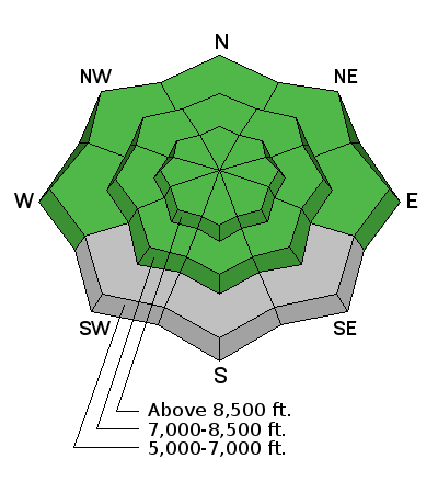
| type | aspect/elevation | characteristics |
|---|

|
|
LIKELIHOOD
 LIKELY
UNLIKELY
SIZE
 LARGE
SMALL
TREND
 INCREASING DANGER
SAME
DECREASING DANGER
|
|
description
Triggered shallow wind slab avalanches are possible on steep slopes in drifted terrain at upper elevations.
Avalanches entraining fresh loose wet snow are possible with midday warmth on steep sunny slopes at upper and mid elevations.
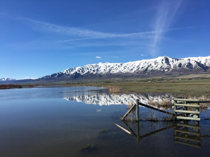
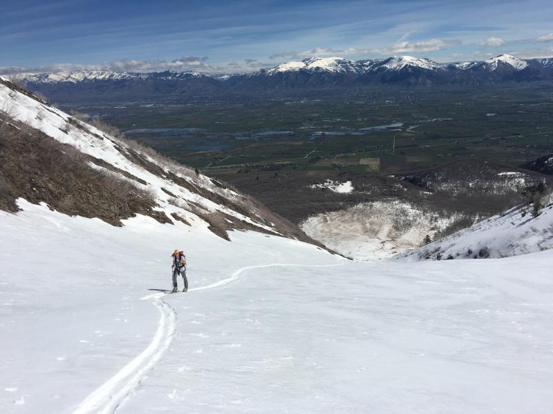
Liam skinning above the huge avalanche debris cone on Maple Bench under Gibson Canyon in the Wellsville Mountain Wilderness. (4/1/17) |
 |
weather Fair weather is expected in the mountains today. A weak weather disturbance will brush northern Utah early Tuesday, followed by the return of high pressure midweek. Today will be mostly sunny, with a high temperature at 8500' of 30 °F and 6 to 9 mph west northwest wind. Tonight will be mostly cloudy with a chance of snow showers. A low temperature of 18 °F and 10 to 14 mph west-northwest wind are expected. On Tuesday, snow showers are possible in the morning, with mostly sunny skies, a high temperature of 31 °F and 14 mph north-northwest wind. |
| general announcements Discount lift tickets for Beaver Mountain, Snowbasin, Powder Mountain, and the Central Wasatch resorts are donated by the resorts to benefit the Utah Avalanche Center. Details and order information here. Do you buy groceries at Smiths? When you register your Smith’s rewards card with their Community Rewards program, they will donate to the Utah Avalanche Center whenever you make a purchase. It's easy, only takes a minute, and doesn't cost you anything. Details here. If you sign up for AmazonSmile and designate the Utah Avalanche Center as your favorite charity, they will donate a portion of everything you spend to the UAC. It doesn't cost you a penny and we'd really appreciate the help. Your information can save lives. If you see anything we should know please help us out by submitting snow and avalanche observations. You can call us at 801-524-5304, email by clicking HERE, or include @utavy in your Instagram. In the Logan Area you can reach me at 435-757-7578 We will update this advisory regularly on Monday, Wednesday, Friday, and Saturday mornings by about 7:30. This advisory is from the U.S.D.A. Forest Service, which is solely responsible for its content. This advisory describes general avalanche conditions and local variations always exist. |