25th Annual Black Diamond Fall Fundraising Party
Thursday, September 13; 6:00-10:00 PM; Black Diamond Parking Lot
25th Annual Black Diamond Fall Fundraising Party
Thursday, September 13; 6:00-10:00 PM; Black Diamond Parking Lot
| Advisory: Logan Area Mountains | Issued by Toby Weed for Friday - March 31, 2017 - 7:02am |
|---|

|
bottom line Heightened avalanche conditions exist on steep slopes in the backcountry. Triggered wind slabs are possible on drifted upper elevation slopes. Wet loose avalanches, entraining saturated fresh snow, will become likely as temperatures warm in the middle of the day. Evaluate snow and terrain carefully. Avoid being on or under steep slopes with saturated or sticky soft snow.
|
 |
special announcement UAC Gear Sale Fundraiser: We still have some donated gear and certificates left over from the season. Want a guided rock climbing or canyoneering trip in Moab? How about a new pair of skis for some spring ski missions? Check out our gear sale photo album to see if we have what you need. This is a fundraising sale for the Utah Avalanche Center. All proceeds benefit avalanche forecasting and education. Click here to visit the sale! |
 |
current conditions The Tony Grove Snotel reports 33 °F and around 7" of new snow in the past 24 hrs. There's 107" of total snow, with 144% of average SWE (Snow Water Equivalent) at 8400'. A 14 mph east-northeast wind is blowing at the CSI Logan Peak weather station and it's 27 °F. Shallow triggered wind slabs are possible near ridge-lines and might be in unexpected places due to unique northeast winds. Seasonally warm daytime temperatures will cause heightened wet avalanche conditions on steep slopes with saturated fresh snow. |
 |
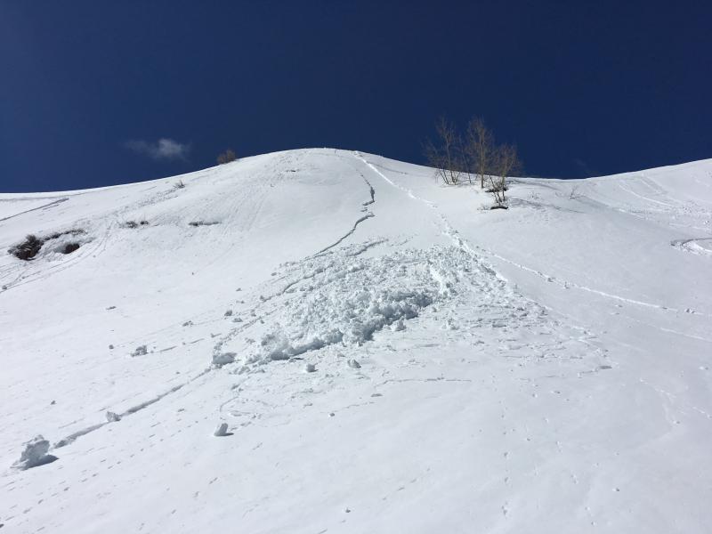
recent activity Tuesday, we easily triggered wet loose avalanches on steep north and east facing slopes off White Pine Knob in the middle of the day. No other avalanches were reported this week. |
| type | aspect/elevation | characteristics |
|---|

|
|
LIKELIHOOD
 LIKELY
UNLIKELY
SIZE
 LARGE
SMALL
TREND
 INCREASING DANGER
SAME
DECREASING DANGER
|
|
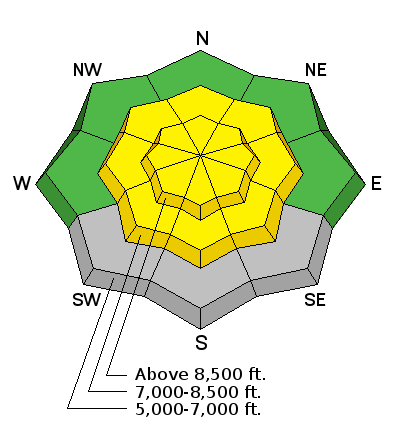
description
Triggered wind slab avalanches are possible on steep slopes in drifted terrain at upper elevations. After last night's somewhat unusual northeast winds, freshly formed drifts near ridge-lines might be found in unexpected places. Moderate east-northeast winds will continue to drift fresh snow today.
|
| type | aspect/elevation | characteristics |
|---|

|
|
LIKELIHOOD
LIKELY
UNLIKELY
SIZE
LARGE
SMALL
TREND
INCREASING DANGER
SAME
DECREASING DANGER
|
|
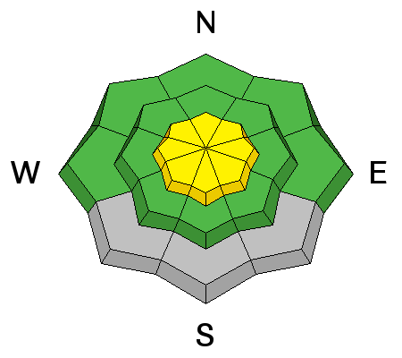
description
Triggered and natural avalanches entraining fresh loose wet snow are possible on steep slopes at upper and mid elevations.
|
 |
weather Stormy weather, centered to our south, will gradually drift east today. High pressure will return for Saturday night through Sunday, followed by another cold front early next week. Today will be mostly cloudy, with 1 to 3 inches of snow possible, a high temperature at 8500' of 39 °F and 11 to 17 mph east-northeast wind. Tonight will be mostly cloudy, a low of 27 °F and 8 to 13 mph northeast wind. Saturday will be mostly sunny, a high temperature of 41 °F and 5 to 8 mph east wind. |
| general announcements Discount lift tickets for Beaver Mountain, Snowbasin, Powder Mountain, and the Central Wasatch resorts are donated by the resorts to benefit the Utah Avalanche Center. Details and order information here. Do you buy groceries at Smiths? When you register your Smith’s rewards card with their Community Rewards program, they will donate to the Utah Avalanche Center whenever you make a purchase. It's easy, only takes a minute, and doesn't cost you anything. Details here. If you sign up for AmazonSmile and designate the Utah Avalanche Center as your favorite charity, they will donate a portion of everything you spend to the UAC. It doesn't cost you a penny and we'd really appreciate the help. Your information can save lives. If you see anything we should know please help us out by submitting snow and avalanche observations. You can call us at 801-524-5304, email by clicking HERE, or include @utavy in your Instagram. In the Logan Area you can reach me at 435-757-7578 We will update this advisory regularly on Monday, Wednesday, Friday, and Saturday mornings by about 7:30. This advisory is from the U.S.D.A. Forest Service, which is solely responsible for its content. This advisory describes general avalanche conditions and local variations always exist. |