25th Annual Black Diamond Fall Fundraising Party
Thursday, September 13; 6:00-10:00 PM; Black Diamond Parking Lot
25th Annual Black Diamond Fall Fundraising Party
Thursday, September 13; 6:00-10:00 PM; Black Diamond Parking Lot
| Advisory: Logan Area Mountains | Issued by Toby Weed for Saturday - March 25, 2017 - 6:51am |
|---|

|
bottom line Heightened wind slab avalanche conditions exist today on steep drifted slopes in the backcountry. Wet loose avalanches, entraining saturated fresh snow are possible at upper and mid elevations, and will become more likely on Sunday with warming temperatures and plenty of sun. Evaluate snow and terrain carefully.
|
 |
special announcement UAC Gear Sale Fundraiser: We still have some donated gear and certificates left over from the season. Want a guided rock climbing or canyoneering trip in Moab? How about a new pair of skis for some spring ski missions? Check out our gear sale photo album to see if we have what you need. This is a fundraising sale for the Utah Avalanche Center. All proceeds benefit avalanche forecasting and education. Click here to visit the sale! |
 |
current conditions The Tony Grove Snotel at 8400' reports 33 °F and 2" of snow from yesterday evening. There's 101" of total snow, with 144% of average SWE (Snow Water Equivalent). A 10 mph southwest wind is blowing at the 9700' CSI Logan Peak weather station and it's 26 °F. Yesterday evening, south winds intensified and blew almost 30 mph for several hours, drifting snow into shallow stiff wind slabs at upper elevations. Today, clouds and cooler temperatures will help control wet loose activity, but it'll be sunny, warm and active again tomorrow.
|
 |
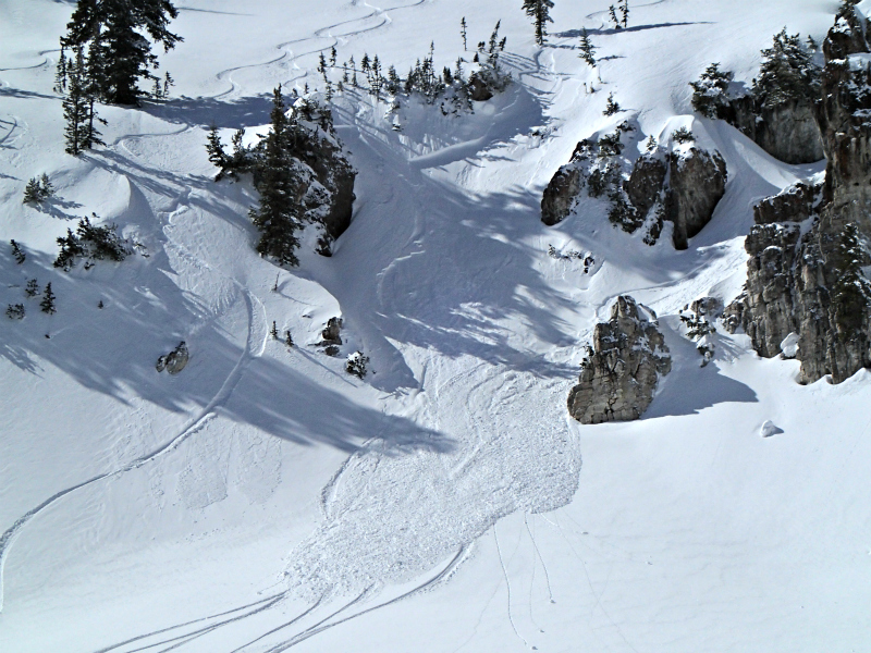
recent activity Yesterday, observers reported triggering several shallow wind slabs on drifted upper elevation slopes in the Central Bear River Range. They also noted a few sled triggered wind slabs and small wet loose avalanches in the area. We intentionally triggered predictable wet loose sluffs in State Line Bowl in upper Sink Hollow. The slow moving avalanches were easily triggered from above, entrained a few inches of saturated new snow and made large piles of heavy debris. |
| type | aspect/elevation | characteristics |
|---|

|
|
LIKELIHOOD
 LIKELY
UNLIKELY
SIZE
 LARGE
SMALL
TREND
 INCREASING DANGER
SAME
DECREASING DANGER
|
|
description
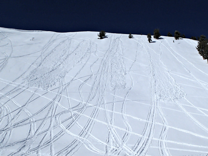
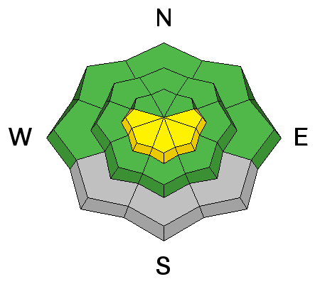
Yesterday, observers reported triggering 1-foot-deep wind slabs at upper elevations in the Central Bear River Range. Drifting increased yesterday evening with south winds and stiff wind slabs formed or were enlarged on upper elevation slopes. Triggered avalanches are possible on slopes steeper than 30 degrees in drifted terrain at upper elevations.
Shallow triggered wind slabs in the Central Bear River Range yesterday, 3/24/17. |
| type | aspect/elevation | characteristics |
|---|

|
|
LIKELIHOOD
LIKELY
UNLIKELY
SIZE
LARGE
SMALL
TREND
INCREASING DANGER
SAME
DECREASING DANGER
|
|
description
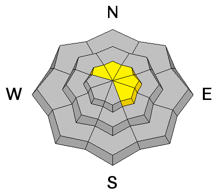
Clouds and cool temperatures will help today, but triggered and natural avalanches entraining fresh loose wet snow are possible on steep slopes at upper and mid elevations. Sun and warmer temperatures on Sunday will cause heightened wet avalanche conditions on steep slopes with saturated fresh snow.
Small sled triggered wet avalanches from yesterday, 3/24/17. |
| type | aspect/elevation | characteristics |
|---|

|
|
LIKELIHOOD
LIKELY
UNLIKELY
SIZE
LARGE
SMALL
TREND
 INCREASING DANGER
SAME
DECREASING DANGER
|
|
description
Overhanging cornices can break further back than expected and trigger avalanches on slopes below. |
 |
weather The upper level trough will move east across the Great Basin today. High pressure aloft will return briefly on Sunday, followed by another storm system for early in the upcoming week. Today, snow showers are likely and 3 to 5 inches of snow is possible, a high temperature at 8500' of 36 °F and 5 to 15 mph west wind veering from the north-northwest in the afternoon. Snow showers will continue tonight, with around an inch possible. It'll be mostly cloudy, a low temperature of 21 °F and 13 to 17 mph northwest wind. Sunday will be mostly sunny, a high temperature of 37 °F and 6 to 13 mph northwest wind. |
| general announcements Discount lift tickets for Beaver Mountain, Snowbasin, Powder Mountain, and the Central Wasatch resorts are donated by the resorts to benefit the Utah Avalanche Center. Details and order information here. Do you buy groceries at Smiths? When you register your Smith’s rewards card with their Community Rewards program, they will donate to the Utah Avalanche Center whenever you make a purchase. It's easy, only takes a minute, and doesn't cost you anything. Details here. If you sign up for AmazonSmile and designate the Utah Avalanche Center as your favorite charity, they will donate a portion of everything you spend to the UAC. It doesn't cost you a penny and we'd really appreciate the help. Your information can save lives. If you see anything we should know please help us out by submitting snow and avalanche observations. You can call us at 801-524-5304, email by clicking HERE, or include @utavy in your Instagram. In the Logan Area you can reach me at 435-757-7578 We will update this advisory regularly on Monday, Wednesday, Friday, and Saturday mornings by about 7:30. This advisory is from the U.S.D.A. Forest Service, which is solely responsible for its content. This advisory describes general avalanche conditions and local variations always exist. |