25th Annual Black Diamond Fall Fundraising Party
Thursday, September 13; 6:00-10:00 PM; Black Diamond Parking Lot
25th Annual Black Diamond Fall Fundraising Party
Thursday, September 13; 6:00-10:00 PM; Black Diamond Parking Lot
| Advisory: Logan Area Mountains | Issued by Toby Weed for Monday - March 13, 2017 - 7:11am |
|---|

|
bottom line Warmth and solar heating will create heightened loose wet avalanche conditions at low elevations and on sunny slopes. Wet slab, cornice fall and glide avalanches are possible and will become more likely in the next few days if nighttime temperatures remain above or near freezing. Evaluate snow and terrain carefully. Stay off of and out from under large cornices, glide cracks, and steep slopes with warmth-softened saturated snow.
|
 |
special announcement Discount lift tickets for Beaver Mountain, Snowbasin, Powder Mountain, and the Central Wasatch resorts are donated by the resorts to benefit the Utah Avalanche Center. Details and order information here. |
 |
current conditions Temperatures hovered around freezing last night, but clear skies allowed the surface snow to refreeze. The Tony Grove Snotel at 8400' reports 33 F and 116" of total snow, with 169% of average SWE (Snow Water Equivalent). It's 26 F and a 22 mph southwest wind at the 9700' CSI Logan Peak weather station. Rising temperatures and Solar warming will quickly soften the snow surface, and heightened wet avalanche conditions will develop in sunny terrain by afternoon. |
 |
recent activity
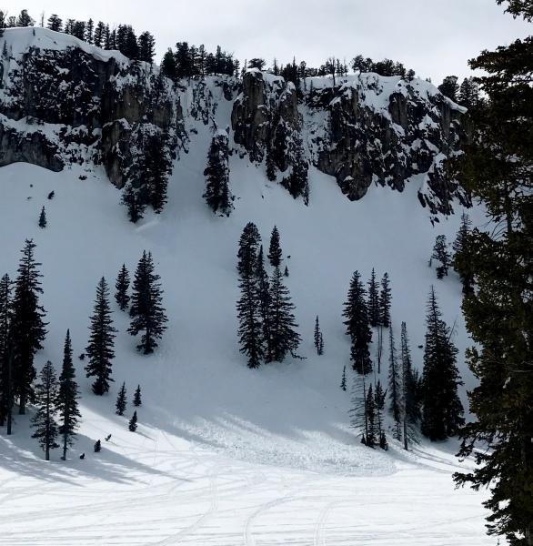
The large White Pine Lake avalanche on 3/11. There is potential for similar avalanches as temperatures climb above 50 F at 9000' in the next few days. |
| type | aspect/elevation | characteristics |
|---|

|
|
LIKELIHOOD
 LIKELY
UNLIKELY
SIZE
 LARGE
SMALL
TREND
 INCREASING DANGER
SAME
DECREASING DANGER
|
description
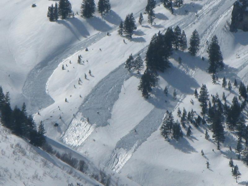
Wet loose avalanches visible Sunday in Pine Canyon in the Wellsville Mountain Wilderness. |
| type | aspect/elevation | characteristics |
|---|

|
|
LIKELIHOOD
LIKELY
UNLIKELY
SIZE
LARGE
SMALL
TREND
INCREASING DANGER
SAME
DECREASING DANGER
|
description
Avoid being under glide cracks like these on Wilderness Peak. In warm weather, you never know when a glide avalanche might occur. |
| type | aspect/elevation | characteristics |
|---|

|
|
LIKELIHOOD
LIKELY
UNLIKELY
SIZE
LARGE
SMALL
TREND
INCREASING DANGER
SAME
DECREASING DANGER
|
description
|
 |
weather Warm and dry high pressure aloft will center over the Great Basin through midweek. A weakening weather disturbance will cross northern Utah and southwest Wyoming Thursday. |
| general announcements Do you buy groceries at Smiths? When you register your Smith’s rewards card with their Community Rewards program, they will donate to the Utah Avalanche Center whenever you make a purchase. It's easy, only takes a minute, and doesn't cost you anything. Details here. If you sign up for AmazonSmile and designate the Utah Avalanche Center as your favorite charity, they will donate a portion of everything you spend to the UAC. It doesn't cost you a penny and we'd really appreciate the help. Your information can save lives. If you see anything we should know please help us out by submitting snow and avalanche observations. You can call us at 801-524-5304, email by clicking HERE, or include @utavy in your Instagram. In the Logan Area you can reach me at 435-757-7578 We will update this advisory regularly on Monday, Wednesday, Friday, and Saturday mornings by about 7:30. This advisory is from the U.S.D.A. Forest Service, which is solely responsible for its content. This advisory describes general avalanche conditions and local variations always exist. |