25th Annual Black Diamond Fall Fundraising Party
Thursday, September 13; 6:00-10:00 PM; Black Diamond Parking Lot
25th Annual Black Diamond Fall Fundraising Party
Thursday, September 13; 6:00-10:00 PM; Black Diamond Parking Lot
| Advisory: Logan Area Mountains | Issued by Toby Weed for Saturday - March 4, 2017 - 6:56am |
|---|

|
bottom line The danger is MODERATE: Snow is deep and mostly stable, but wind slab and cornice fall avalanches are possible on drifted upper elevation slopes. Sun and warm temperatures will cause a rising danger of loose wet avalanches in sunny and low elevation terrain. Use normal caution, avoid travel on or under large cornices, drifted slopes, and steep sunny terrain in the heat of the day.
|
 |
current conditions The Tony Grove Snotel at 8400' reports 34 F and 117"of total snow with 165% of average SWE (Snow Water Equivalent). It's 27 F at the 9700' CSI Logan Peak weather station, and a south-southeast wind is blowing 32 mph, gusting to 51 mph. Snow is deep, settled and mostly stable. The danger is LOW on most slopes this morning, but avalanches are still possible. Only expose one person at a time, and watch each other from safe places. Recent growth of large cornices, drifting from south wind overnight, high angled sun and temperatures well above freezing are creating heightened avalanche conditions on drifted upper elevation and sun warmed slopes. Don't linger under cornices or steep sunny slopes because natural avalanches might occur, especially during the heat of the day. |
 |
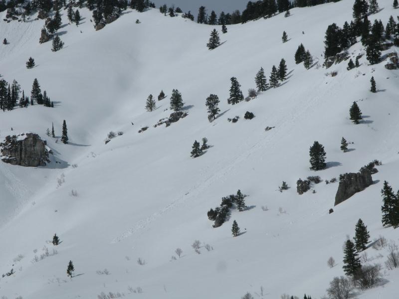
recent activity There was some natural wind slab, cornice fall, and loose avalanche activity during the stormy weather earlier in the week. Recent storm snow avalanches did not step into old layers. Thursday a party triggered a small wind slab on a very steep roll in the Tony Grove Area, and natural cornice falls and wind slabs were observed in the Wellsville and Central Bear River Ranges.
A recent natural wind slab avalanche on the southeast face of Mount Gog. (3/2/2017) |
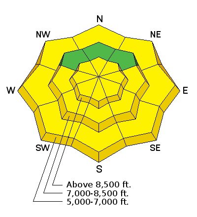
| type | aspect/elevation | characteristics |
|---|

|

|
LIKELIHOOD
 LIKELY
UNLIKELY
SIZE
 LARGE
SMALL
TREND
 INCREASING DANGER
SAME
DECREASING DANGER
|
|
description
South winds increased overnight and likely formed stiff drifts along exposed ridges.
|
| type | aspect/elevation | characteristics |
|---|

|
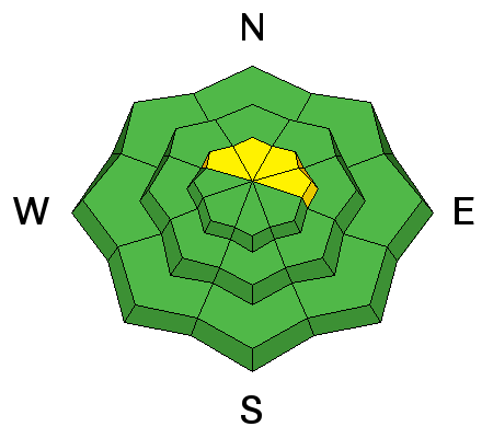
|
LIKELIHOOD
LIKELY
UNLIKELY
SIZE
LARGE
SMALL
TREND
INCREASING DANGER
SAME
DECREASING DANGER
|
description
Cornice Fall on Castle Rock. (3/2/17) |
| type | aspect/elevation | characteristics |
|---|

|
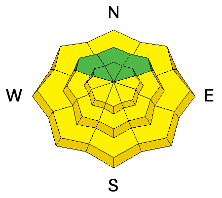
|
LIKELIHOOD
LIKELY
UNLIKELY
SIZE
LARGE
SMALL
TREND
 INCREASING DANGER
SAME
DECREASING DANGER
|
|
description
Warmth and sun create heightened wet avalanche conditions on sunny slopes during the heat of the day. Loose wet avalanches entraining significant piles of moist fresh snow are possible.
Recent natural wet loose avalanches in Wood Camp Hollow. (3/3/17) |
 |
weather High pressure will shift east this weekend ahead of a cold Pacific storm, which will cross the Great Basin Sunday through Monday. Expect partly cloudy conditions, a high temperature at 8500' of 37 F and southwest wind 25 to 30 mph, gusting to 40 mph. It will be mostly cloudy tonight, low temperature of 27 F and 25 mph south-southwest wind. Snow will arrive tomorrow after about 11:00 AM, high temperature of 35 F, and southwest wind increasing to around 30 mph, gusting near 50 mph. Snow and wind will continue Sunday night, with 14 to 22 inches of new snow possible by Monday morning. |
| general announcements Do you buy groceries at Smiths? When you register your Smith’s rewards card with their Community Rewards program, they will donate to the Utah Avalanche Center whenever you make a purchase. It's easy, only takes a minute, and doesn't cost you anything. Details here. Discount lift tickets for Beaver Mountain, Snowbasin, Powder Mountain, and the Central Wasatch resorts are donated by the resorts to benefit the Utah Avalanche Center. Details and order information here. If you sign up for AmazonSmile and designate the Utah Avalanche Center as your favorite charity, they will donate a portion of everything you spend to the UAC. It doesn't cost you a penny and we'd really appreciate the help. Your information can save lives. If you see anything we should know please help us out by submitting snow and avalanche observations. You can call us at 801-524-5304, email by clicking HERE, or include @utavy in your Instagram. In the Logan Area you can reach me at 435-757-7578 We will update this advisory regularly on Monday, Wednesday, Friday, and Saturday mornings by about 7:30. This advisory is from the U.S.D.A. Forest Service, which is solely responsible for its content. This advisory describes general avalanche conditions and local variations always exist. |