25th Annual Black Diamond Fall Fundraising Party
Thursday, September 13; 6:00-10:00 PM; Black Diamond Parking Lot
25th Annual Black Diamond Fall Fundraising Party
Thursday, September 13; 6:00-10:00 PM; Black Diamond Parking Lot
| Advisory: Logan Area Mountains | Issued by Toby Weed for Wednesday - March 1, 2017 - 7:07am |
|---|

|
bottom line CONSIDERABLE: We've been finding deep, generally stable snow in most terrain, but dangerous avalanche conditions exist on drifted upper and mid elevation slopes. Triggered wind slab, cornice fall, and loose avalanches involving new snow are likely and naturals are possible. Solar warming will cause an increasing danger of loose wet sluffs entraining moist surface snow, and natural wet avalanches are likely with clearing tomorrow. Evaluate snow and terrain carefully, choose conservative routes, and avoid travel on or under cornices and steep sunny slopes.
|
 |
current conditions We are finding deep and generally stable snow on most slopes, but drifting from westerly winds yesterday afternoon and overnight created dangerous cornice fall and wind slab conditions in exposed upper and mid elevation terrain. The Tony Grove Snotel at 8400' reports 13 F and 1" 24 hr SWE (Snow Water Equivalent). It's hard to tell how much new snow there is due to significant settlement in the top layers of the snowpack, but there is 129"of total snow with 166% of average SWE. It's 15 F at the UDOT Hwy 89 Logan Summit and west-northwest winds intensified yesterday evening and were sustained overnight at 25 mph, gusting to 46 mph. |
 |
recent activity There has been natural activity during the past few days at upper elevations, but no significant avalanches have been reported or observed. |
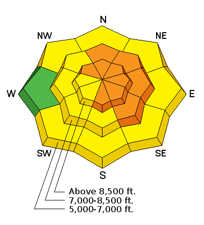
| type | aspect/elevation | characteristics |
|---|

|
|
LIKELIHOOD
 LIKELY
UNLIKELY
SIZE
 LARGE
SMALL
TREND
 INCREASING DANGER
SAME
DECREASING DANGER
|
|
description
West winds increased significantly yesterday afternoon and continued through the night, drifting light snow into lee-slope avalanche starting zones. Avoid wind slabs on the lee side of ridges and in and around terrain features like gullies, scoops, sub-ridges, and cliff-bands. |
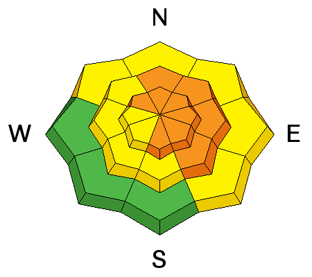
| type | aspect/elevation | characteristics |
|---|

|
|
LIKELIHOOD
LIKELY
UNLIKELY
SIZE
LARGE
SMALL
TREND
 INCREASING DANGER
SAME
DECREASING DANGER
|
|
description
Huge, overhanging cornices can break further back than expected and trigger avalanches on slopes below. Drifting from west winds is rapidly building these monsters and natural cornice falls are possible. Solar warming and rising temperatures tomorrow and heading into the weekend will cause a continuing threat of natural activity. |
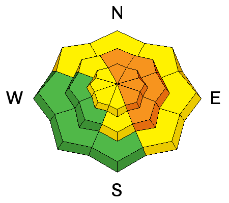
| type | aspect/elevation | characteristics |
|---|

|
|
LIKELIHOOD
 LIKELY
UNLIKELY
SIZE
LARGE
SMALL
TREND
 INCREASING DANGER
SAME
DECREASING DANGER
|
|
description
Loose wet avalanches entraining significant piles of moist fresh snow may become an issue with solar warming if the clouds break up today. If you start to see roller balls, pin wheels, or natural sluffs, it's time to leave. Natural wet activity is likely on sunny slopes with clearing and warming temperatures on Thursday. |
 |
weather An increasingly dry and warmer west-northwesterly flow aloft will set up for the latter half of the week. Precipitation could return to region late in the weekend. It'll be mostly cloudy today, high temperature at 8500' of 22 F, 15 mph west wind, and 1 or 2 inches of snow possible. It'll be mostly cloudy tonight with a low of 13 F, and 15 mph west wind. It'll be much warmer and sunny tomorrow, high temperature of 31 F, and a 10 mph west wind. |
| general announcements Do you buy groceries at Smiths? When you register your Smith’s rewards card with their Community Rewards program, they will donate to the Utah Avalanche Center whenever you make a purchase. It's easy, only takes a minute, and doesn't cost you anything. Details here. Discount lift tickets for Beaver Mountain, Snowbasin, Powder Mountain, and the Central Wasatch resorts are donated by the resorts to benefit the Utah Avalanche Center. Details and order information here. If you sign up for AmazonSmile and designate the Utah Avalanche Center as your favorite charity, they will donate a portion of everything you spend to the UAC. It doesn't cost you a penny and we'd really appreciate the help. Your information can save lives. If you see anything we should know please help us out by submitting snow and avalanche observations. You can call us at 801-524-5304, email by clicking HERE, or include @utavy in your Instagram. In the Logan Area you can reach me at 435-757-7578 We will update this advisory regularly on Monday, Wednesday, Friday, and Saturday mornings by about 7:30. This advisory is from the U.S.D.A. Forest Service, which is solely responsible for its content. This advisory describes general avalanche conditions and local variations always exist. |


