25th Annual Black Diamond Fall Fundraising Party
Thursday, September 13; 6:00-10:00 PM; Black Diamond Parking Lot
25th Annual Black Diamond Fall Fundraising Party
Thursday, September 13; 6:00-10:00 PM; Black Diamond Parking Lot
| Advisory: Logan Area Mountains | Issued by Toby Weed for Monday - February 27, 2017 - 7:05am |
|---|

|
bottom line The danger is CONSIDERABLE on drifted upper and mid elevation slopes. Triggered wind slab, cornice fall, and loose avalanches are likely. Natural avalanches are possible, more likely during periods of heavy snowfall. Evaluate snow and terrain carefully, choose conservative routes, and avoid travel on or under steep drifted slopes.
|
 |
special announcement Do you buy groceries at Smiths? When you register your Smith’s rewards card with their Community Rewards program, they will donate to the Utah Avalanche Center whenever you make a purchase. It's easy, only takes a minute, and doesn't cost you anything. Details here. |
 |
current conditions Yet another goggle day, with a foot of fluffy new snow up high and more on the way. The National Weather Service has issued a Winter Weather Advisory for Cache Valley and the surrounding mountains through tomorrow morning. The Tony Grove Snotel reports 18 F and 11" of snow since midnight, and .8" 24 hr SWE (Snow Water Equivalent). There's more than 10' of total snow at 8400', 128" with 166% of average SWE. It's 10 F at the CSI Logan Peak weather station at 9700'. Prefrontal south-southeast winds increased yesterday afternoon and and blew 25 mph, gusting to 40 mph for several hours before midnight. Winds diminished significantly and veered from south to west this morning, currently 7 mph out of the west-southwest.
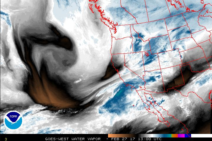
This morning's water vapor imagery shows an "atmospheric river" and with cold temperatures, it's bringing more powder |
 |
recent activity It was a busy weekend in the Logan Zone, and no avalanches were reported.
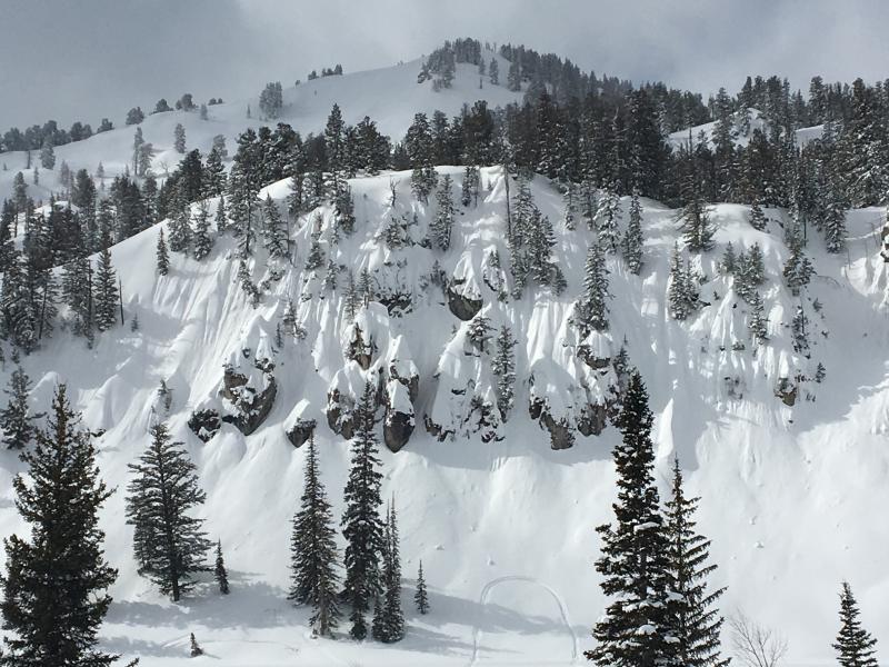
West side of Tony Grove Lake on 2/26/17 |
| type | aspect/elevation | characteristics |
|---|

|

|
LIKELIHOOD
 LIKELY
UNLIKELY
SIZE
 LARGE
SMALL
TREND
 INCREASING DANGER
SAME
DECREASING DANGER
|
|
description
South winds increased significantly yesterday afternoon and early last night, drifting last week's light snow into lee-slope avalanche starting zones. Avoid forming and buried wind slabs on the lee side of ridges and in and around terrain features like gullies, scoops, sub-ridges, and cliff-bands.
Huge, overhanging cornices can break further back than expected and trigger avalanches on slopes below. |
| type | aspect/elevation | characteristics |
|---|

|

|
LIKELIHOOD
LIKELY
UNLIKELY
SIZE
LARGE
SMALL
TREND
INCREASING DANGER
SAME
DECREASING DANGER
|
|
description
Triggered storm snow (soft slab and loose) avalanches are likely and naturals possible in steep terrain, especially during periods of very heavy snowfall. |
 |
weather The next cold Pacific storm system will impact much of the area through at least Tuesday evening. An increasingly dry and mild westerly flow aloft will set up for the latter half of the week. 5 to 9 inches of snow is possible at 8500' today, high temperature of 22 F, and 18 to 20 mph west-southwest winds. It'll be mostly cloudy tonight, low temperature of 7 F, 17 to 22 mph west wind, and maybe an inch of snow. 3 to 5 inches of snow is possible tomorrow, high temperature of 17 F, and increasing 16 to 21 mph west wind. |
| general announcements Any time is a great time to practice companion rescue techniques with your partners. Companion Rescue Practice Video Discount lift tickets for Beaver Mountain, Snowbasin, Powder Mountain, and the Central Wasatch resorts are donated by the resorts to benefit the Utah Avalanche Center. Details and order information here. If you sign up for AmazonSmile and designate the Utah Avalanche Center as your favorite charity, they will donate a portion of everything you spend to the UAC. It doesn't cost you a penny and we'd really appreciate the help. Your information can save lives. If you see anything we should know please help us out by submitting snow and avalanche observations. You can call us at 801-524-5304, email by clicking HERE, or include @utavy in your Instagram. In the Logan Area you can reach me at 435-757-7578 We will update this advisory regularly on Monday, Wednesday, Friday, and Saturday mornings by about 7:30. This advisory is from the U.S.D.A. Forest Service, which is solely responsible for its content. This advisory describes general avalanche conditions and local variations always exist. |