25th Annual Black Diamond Fall Fundraising Party
Thursday, September 13; 6:00-10:00 PM; Black Diamond Parking Lot
25th Annual Black Diamond Fall Fundraising Party
Thursday, September 13; 6:00-10:00 PM; Black Diamond Parking Lot
| Advisory: Logan Area Mountains | Issued by Toby Weed for Friday - February 24, 2017 - 7:00am |
|---|

|
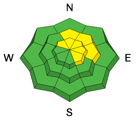
bottom line The danger is MODERATE, heightened avalanche conditions exist at upper and mid elevations. Triggered storm snow, cornice fall, and wind slab avalanches are possible. Periods of very heavy snow or stronger than expected wind will cause an increase in danger and the possibility for natural activity. Evaluate snow and terrain carefully, and avoid travel on or under large cornices and steep drifted slopes.
|
 |
special announcement Discount lift tickets for Beaver Mountain, Snowbasin, Powder Mountain, and the Central Wasatch resorts are donated by the resorts to benefit the Utah Avalanche Center. Details and order information here. |
 |
current conditions A good day to call in sick or find some other way to get out into the backcountry and enjoy stellar Utah powder conditions. The 8400' Tony Grove Snotel reports 10 F and 6" of snow with .5" SWE in the last 24 hrs and 1.3" SWE in the last 48 hrs. It's 2 F at the CSI Logan Peak weather station at 9700'. The wind sensor is encased by ice and not working, but winds are in the low single digits at the UDOT Hwy 89 summit, and on Ogden Peak west winds are blowing 6 mph, gusting to around 30 mph. I found top notch powder riding in the Tony Grove Area yesterday. |
 |
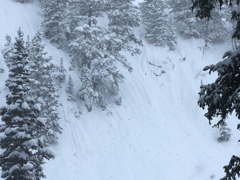
recent activity Numerous natural dry sluffs and a few shallow soft slabs involving dry surface snow occurred yesterday on very steep slopes in the Tony Grove Area..
|
| type | aspect/elevation | characteristics |
|---|

|
|
LIKELIHOOD
 LIKELY
UNLIKELY
SIZE
 LARGE
SMALL
TREND
 INCREASING DANGER
SAME
DECREASING DANGER
|
|
description
Triggered storm slabs and dry sluffs are possible at mid and upper elevations. These will likely be small avalanches, and the fresh snow is quite light, so shouldn't be much of a threat. Small natural avalanches are possible, especially during periods of very heavy snowfall, so avoid being under very steep slopes. |
| type | aspect/elevation | characteristics |
|---|

|
|
LIKELIHOOD
LIKELY
UNLIKELY
SIZE
 LARGE
SMALL
TREND
 INCREASING DANGER
SAME
DECREASING DANGER
|
description
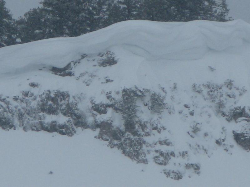
Huge cornices exist on exposed ridges at upper elevations |
 |
weather A cold upper trough over the area this morning will shift east this afternoon. The next system will cross the area Saturday afternoon and night, with yet another cold storm on tap for the first part of next week. Snow showers are likely today with 2 to 4 inches possible, 8500' high temperatures of 22 F, and west wind 11 to 14 mph. It'll be mostly cloudy tonight, with 2 to 4 inches of snow possible, a low temperature around 6 F and 8 to 13 mph west wind. There's a 30% chance of snow tomorrow, It'll be mostly cloudy, with a high temperature of 21 F, and 9 to 14 mph west-southwest wind. |
| general announcements Any time is a great time to practice companion rescue techniques with your partners. Companion Rescue Practice Video Do you buy groceries at Smiths? When you register your Smith’s rewards card with their Community Rewards program, they will donate to the Utah Avalanche Center whenever you make a purchase. It's easy, only takes a minute, and doesn't cost you anything. Details here. If you sign up for AmazonSmile and designate the Utah Avalanche Center as your favorite charity, they will donate a portion of everything you spend to the UAC. It doesn't cost you a penny and we'd really appreciate the help. Your information can save lives. If you see anything we should know please help us out by submitting snow and avalanche observations. You can call us at 801-524-5304, email by clicking HERE, or include @utavy in your Instagram. In the Logan Area you can reach me at 435-757-7578 We will update this advisory regularly on Monday, Wednesday, Friday, and Saturday mornings by about 7:30. This advisory is from the U.S.D.A. Forest Service, which is solely responsible for its content. This advisory describes general avalanche conditions and local variations always exist. |