25th Annual Black Diamond Fall Fundraising Party
Thursday, September 13; 6:00-10:00 PM; Black Diamond Parking Lot
25th Annual Black Diamond Fall Fundraising Party
Thursday, September 13; 6:00-10:00 PM; Black Diamond Parking Lot
| Advisory: Logan Area Mountains | Issued by Toby Weed for Wednesday - February 22, 2017 - 6:48am |
|---|

|
bottom line Dangerous conditions exist, triggered hard slab avalanches and large cornice falls are likely on drifted upper elevation slopes. With temperatures well below freezing, the moist snow is hardening and is mostly stable at low elevations and in sheltered terrain. Evaluate snow and terrain carefully, make cautious decisions, and avoid travel on or under large cornices and steep drifted slopes.
|
 |
special announcement Discount lift tickets for Beaver Mountain, Snowbasin, Powder Mountain, and the Central Wasatch resorts are donated by the resorts to benefit the Utah Avalanche Center. Details and order information here. |
 |
current conditions Powerful southwest winds diminished significantly last night after the evening's electrical frontal passage. Temperatures dropped as well, and it's 22 F at UDOT Hwy 89 Summit. Beaver Mountain reports 7" of new snow and 17 F. It's 15 F at the CSI Logan Peak weather station at 9700', with 4 mph southwest wind. The snow was like mashed potatoes even on north facing upper elevation slopes yesterday, but the super strong southwest winds were still able to pick it up. Although much of the snow in spindrift off the high peaks sublimated into the atmosphere, drifting created dangerous hard wind slab avalanche conditions on lee slopes at upper elevations. A drop in temperatures will help to set up the snow at low and mid elevations, increasing stability. |
 |
recent activity
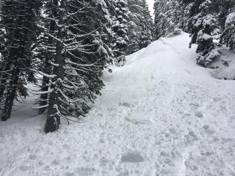
I intentionally triggered this storm slab on a very steep test slope above the Tony Grove Campground. |
| type | aspect/elevation | characteristics |
|---|

|
|
LIKELIHOOD
 LIKELY
UNLIKELY
SIZE
 LARGE
SMALL
TREND
 INCREASING DANGER
SAME
DECREASING DANGER
|
|
description
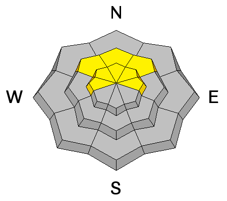
Triggered hard wind slab avalanches are possible at upper elevations.
|
| type | aspect/elevation | characteristics |
|---|

|

|
LIKELIHOOD
 LIKELY
UNLIKELY
SIZE
LARGE
SMALL
TREND
INCREASING DANGER
SAME
DECREASING DANGER
|
|
description
Huge, overhanging cornices exist on the high ridges and are suspect due to recent warmth and wind. Cornices can break further back than expected and might trigger avalanches on slopes below. |
| type | aspect/elevation | characteristics |
|---|

|
|
LIKELIHOOD
LIKELY
UNLIKELY
SIZE
 LARGE
SMALL
TREND
 INCREASING DANGER
SAME
DECREASING DANGER
|
|
description
Persistent slab avalanches, 2' deep, failing on small faceted grains and running on the 2/10 rain-crust are possible on some upper and mid elevation north facing slopes. |
 |
weather A cold upper trough will cross the region today and tonight. A cold moist and unstable northwest flow will follow the trough Thursday into Friday. Expect snow today, with 3 to 5 inches possible, 8500' high temperatures of 30 F, and 6 to 10 mph southwest wind. 5 to 9 inches of snow is possible tonight, with a low temperature of 15 F and 8 mph west-southwest winds. Snow is likely tomorrow, with another 7 to 11 inches possible, 10 to 15 mph west-northwest wind, and a high temperature of 22 F. Snow showers will continue tomorrow night with another 3 to 5 inches possible, low temperatures of 10 F and 10 to 15 mph northwest wind. |
| general announcements Any time is a great time to practice companion rescue techniques with your partners. Companion Rescue Practice Video Do you buy groceries at Smiths? When you register your Smith’s rewards card with their Community Rewards program, they will donate to the Utah Avalanche Center whenever you make a purchase. It's easy, only takes a minute, and doesn't cost you anything. Details here. If you sign up for AmazonSmile and designate the Utah Avalanche Center as your favorite charity, they will donate a portion of everything you spend to the UAC. It doesn't cost you a penny and we'd really appreciate the help. Your information can save lives. If you see anything we should know please help us out by submitting snow and avalanche observations. You can call us at 801-524-5304, email by clicking HERE, or include @utavy in your Instagram. In the Logan Area you can reach me at 435-757-7578 We will update this advisory regularly on Monday, Wednesday, Friday, and Saturday mornings by about 7:30. This advisory is from the U.S.D.A. Forest Service, which is solely responsible for its content. This advisory describes general avalanche conditions and local variations always exist. |