25th Annual Black Diamond Fall Fundraising Party
Thursday, September 13; 6:00-10:00 PM; Black Diamond Parking Lot
25th Annual Black Diamond Fall Fundraising Party
Thursday, September 13; 6:00-10:00 PM; Black Diamond Parking Lot
| Advisory: Logan Area Mountains | Issued by Toby Weed for Saturday - February 18, 2017 - 6:59am |
|---|

|
bottom line The danger is MODERATE and heightened avalanche conditions exist in the backcountry. Triggered wind slab avalanches are possible on drifted upper elevation slopes. Snow is stable in most other terrain, but shallow wet avalanches entraining saturated surface snow are possible on shady slopes in the heat of midday. Use normal caution, avoid drifted slopes at upper elevations and steep slopes with saturated surface snow above trees, cliffs, or other terrain traps.
|
 |
special announcement Discount lift tickets for Beaver Mountain, Snowbasin, Powder Mountain, and the Central Wasatch resorts are donated by the resorts to benefit the Utah Avalanche Center. Details and order information here. |
 |
current conditions The 8400' Tony Grove Snotel reports 32 F, 3" of new snow, and a bit of rain overnight. There's 100" of total snow containing 160% of average SWE (Snow Water Equivalent) . It's 25 F at the CSI Logan Peak weather station at 9700', and the wind is from the south at 31 mph, gusting to 56 mph early this morning. The fresh snow will help freshen-up and smooth-in variable and crusty backcountry snow conditions. Soft, shallow, re-crystallized snow exists on shady upper elevation slopes, with melt-freeze crusts or slushy surface snow elsewhere. Not far under the snow surface at all elevations is a thick and hard crust formed by warmth and copious rain last week. Wind slab and loose avalanches involving the surface snow are possible, but the thick and bomber crust is holding the deeper snowpack together. |
 |
recent activity
|
| type | aspect/elevation | characteristics |
|---|

|
|
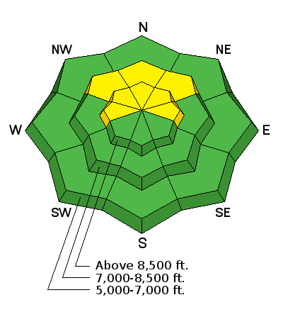
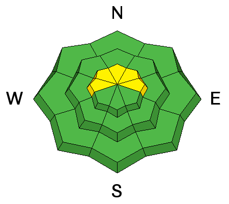
LIKELIHOOD
 LIKELY
UNLIKELY
SIZE
 LARGE
SMALL
TREND
 INCREASING DANGER
SAME
DECREASING DANGER
|
description
|
| type | aspect/elevation | characteristics |
|---|

|
|
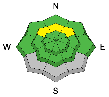
LIKELIHOOD
LIKELY
UNLIKELY
SIZE
 LARGE
SMALL
TREND
 INCREASING DANGER
SAME
DECREASING DANGER
|
|
description
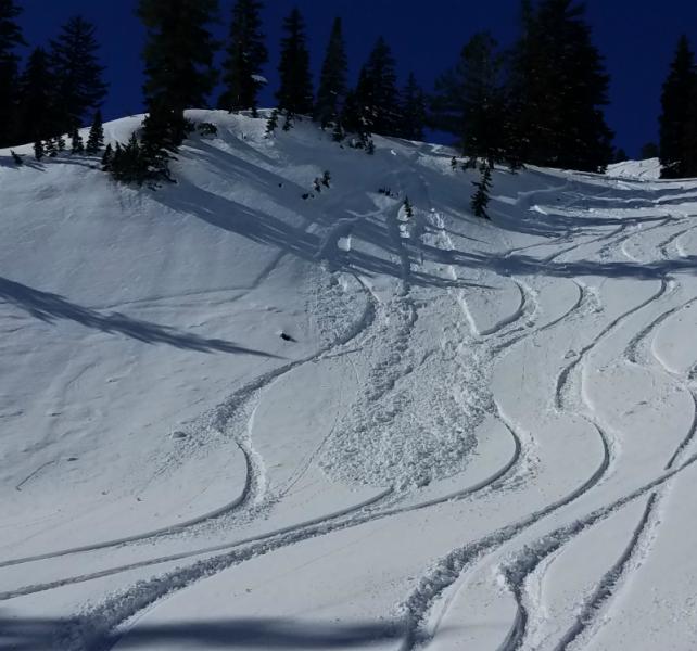
As the shallow soft snow at mid-elevations is warmed by daytime heating, it'll be prone to sluffing. Warm temperatures again today will cause an increasing danger of shallow loose wet avalanches on steep slopes. Triggered wet sluffs will entrain a few inches of sloppy, saturated snow and run on last week's thick crust.
Triggered wet sluffs above Tony Grove Lake (Flygare 2-13-17) |
 |
weather The upper level trough along the California coast will work slowly east across the desert southwest and Great Basin through the weekend. High pressure aloft will return early next week, followed by a new and rather cold storm system arriving midweek. It'll be cloudy today in the mountains, with a chance of snow, 8500' high temperature of 38 F, and 15 to 20 mph south wind. 1 to 2 inches of new snow is likely tonight, with a low temperature of 29 F, and 11 to 13 mph south wind. It will snow tomorrow, with 3 to 7 inches possible, a high temperature of 35 F, and 10 to 15 mph west wind. |
| general announcements Any time is a great time to practice companion rescue techniques with your partners. Companion Rescue Practice Video Do you buy groceries at Smiths? When you register your Smith’s rewards card with their Community Rewards program, they will donate to the Utah Avalanche Center whenever you make a purchase. It's easy, only takes a minute, and doesn't cost you anything. Details here. If you sign up for AmazonSmile and designate the Utah Avalanche Center as your favorite charity, they will donate a portion of everything you spend to the UAC. It doesn't cost you a penny and we'd really appreciate the help. Your information can save lives. If you see anything we should know please help us out by submitting snow and avalanche observations. You can call us at 801-524-5304, email by clicking HERE, or include @utavy in your Instagram. In the Logan Area you can reach me at 435-757-7578 We will update this advisory regularly on Monday, Wednesday, Friday, and Saturday mornings by about 7:30. This advisory is from the U.S.D.A. Forest Service, which is solely responsible for its content. This advisory describes general avalanche conditions and local variations always exist. |