25th Annual Black Diamond Fall Fundraising Party
Thursday, September 13; 6:00-10:00 PM; Black Diamond Parking Lot
25th Annual Black Diamond Fall Fundraising Party
Thursday, September 13; 6:00-10:00 PM; Black Diamond Parking Lot
| Advisory: Logan Area Mountains | Issued by Toby Weed for Friday - February 17, 2017 - 6:45am |
|---|

|
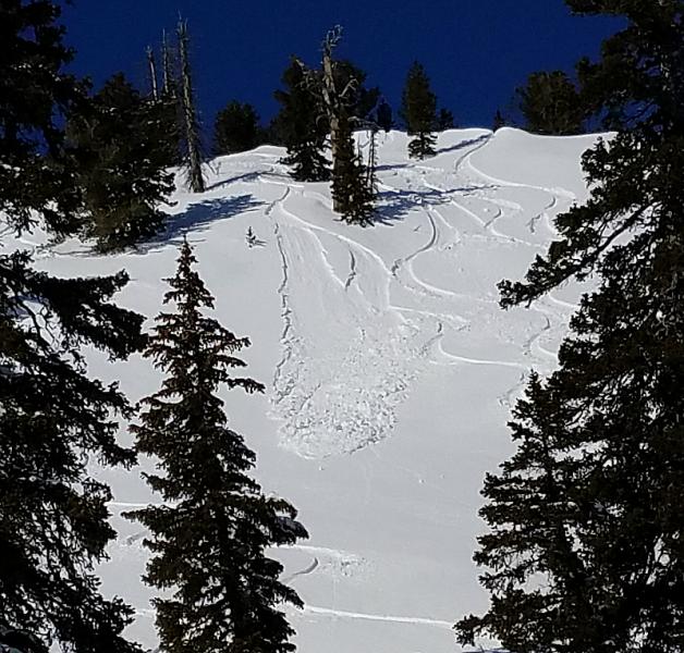
bottom line The danger is LOW and snow is mostly stable in the backcountry. Even so, triggered wind slab avalanches are possible on drifted upper elevation slopes. Daytime warming will cause a rising danger of shallow wet avalanches entraining loose saturated surface snow. Use normal caution, and avoid drifted slopes at upper elevations and steep slopes with saturated surface snow above trees, cliffs, or other terrain traps.
|
 |
current conditions The 8400' Tony Grove Snotel reports 26 F and 98" of total snow containing 160% of average SWE (Snow Water Equivalent) . It's 23 F at the CSI Logan Peak weather station at 9700', and the wind is from the southwest at 16 mph. There's a few inches of settled powder on shady upper elevation slopes, but the week-old snow has seen too much wind, sun, and warmth elsewhere, creating variable conditions. Under the soft surface is a thick and hard crust formed by warmth and copious rain last week. Small wind slab avalanches and shallow wet sluffs are possible involving surface layers, but the bomber crust is holding the deeper snowpack together. |
 |
recent activity
|
| type | aspect/elevation | characteristics |
|---|

|
|
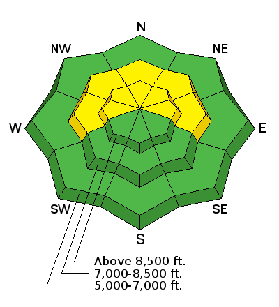
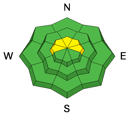
LIKELIHOOD
 LIKELY
UNLIKELY
SIZE
 LARGE
SMALL
TREND
 INCREASING DANGER
SAME
DECREASING DANGER
|
description
|
| type | aspect/elevation | characteristics |
|---|

|
|
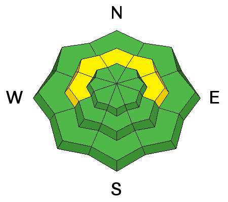
LIKELIHOOD
 LIKELY
UNLIKELY
SIZE
 LARGE
SMALL
TREND
 INCREASING DANGER
SAME
DECREASING DANGER
|
description
|
 |
weather The upper level trough off the California coast will send moisture along with a series of weather disturbances across Utah through the weekend. High pressure aloft will return early next week, followed by another round of active weather midweek. Snow is possible this afternoon, but less than an inch is expected. We'll see increasing clouds, and a high temperature at 8500' of 38 F. Light winds will become 5 to 7 mph from the south-southeast in the afternoon. 2 to 4 inches of snow is expected tonight, with a low temperature of 29 F and 7 to 17 mph south-southwest wind. Snow is likely tomorrow morning, but looks like we'll be lucky to see more than a half inch. It'll be cloudy with a high temperature of 36 F and breezy, with 21 to 26 mph south wind, gusting to 40 mph. A couple inches of snow is possible Saturday night, with southwest wind 8 to 15 mph, and a low temperature of 29 F. |
| general announcements Any time is a great time to practice companion rescue techniques with your partners. Companion Rescue Practice Video Do you buy groceries at Smiths? When you register your Smith’s rewards card with their Community Rewards program, they will donate to the Utah Avalanche Center whenever you make a purchase. It's easy, only takes a minute, and doesn't cost you anything. Details here. If you sign up for AmazonSmile and designate the Utah Avalanche Center as your favorite charity, they will donate a portion of everything you spend to the UAC. It doesn't cost you a penny and we'd really appreciate the help. Discount lift tickets for Beaver Mountain, Snowbasin, Powder Mountain, and the Central Wasatch resorts are donated by the resorts to benefit the Utah Avalanche Center. Details and order information here. Your information can save lives. If you see anything we should know please help us out by submitting snow and avalanche observations. You can call us at 801-524-5304, email by clicking HERE, or include @utavy in your Instagram. In the Logan Area you can reach me at 435-757-7578 We will update this advisory regularly on Monday, Wednesday, Friday, and Saturday mornings by about 7:30. This advisory is from the U.S.D.A. Forest Service, which is solely responsible for its content. This advisory describes general avalanche conditions and local variations always exist. |