25th Annual Black Diamond Fall Fundraising Party
Thursday, September 13; 6:00-10:00 PM; Black Diamond Parking Lot
25th Annual Black Diamond Fall Fundraising Party
Thursday, September 13; 6:00-10:00 PM; Black Diamond Parking Lot
| Advisory: Logan Area Mountains | Issued by Toby Weed for Wednesday - February 15, 2017 - 6:07am |
|---|

|
bottom line The danger is LOW and the snow is mostly stable in the backcountry today. Even so, small triggered wind slabs and loose snow avalanches are possible on steep slopes. Solar warming will cause a rising danger of shallow wet avalanches entraining loose saturated snow in sunny terrain. Use normal caution, and avoid steep drifted or sunny slopes above trees, cliffs, or other terrain traps.
|
 |
current conditions The 8400' Tony Grove Snotel reports 34 F and 104" of total snow containing 163% of average SWE (Snow Water Equivalent) . It's 32 F at the CSI Logan Peak weather station at 9700', and the wind is from the south-southeast at 13 mph. There's a bit less than a foot of settled powder at upper elevations from Friday on a bomber crust formed by warmth and copius rain last week. Small avalanches involving the soft surface snow are possible, but the thick solid crust is holding the deep snowpack together. |
 |
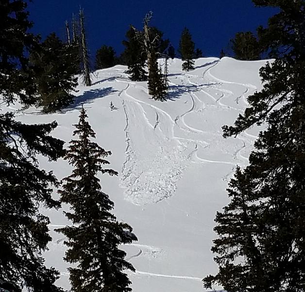
recent activity -Numerous shallow sled and board triggered wind slabs were reported from drifted upper elevation terrain in the Bear River Range over the weekend. The small soft slab avalanches usually occurred in expected drifted steep areas, and were about 8" deep and mostly 50' wide, but one was 120' wide and ran around 1000' vrt. -A couple parties reported triggering wet and dry sluffs as well as a few small soft slabs on Monday in the Tony Grove Area.
Wet sluffs involving new snow from last Friday were common over the weekend and on Monday on upper elevation sunny slopes. |
| type | aspect/elevation | characteristics |
|---|

|
|
LIKELIHOOD
 LIKELY
UNLIKELY
SIZE
 LARGE
SMALL
TREND
 INCREASING DANGER
SAME
DECREASING DANGER
|
|
description
Shallow wind slabs were quite sensitive over the weekend at upper elevations, but time and settlement have mostly healed the instability. The easily triggered soft slabs involving about 8" of fresh snow were running on a rain-crust from Friday's warm and wet storm. Triggered wind slab avalanches remain possible, but the small avalanches involving shallow soft snow are not much of a threat. The loose snow above the thick crust is quickly becoming faceted on shady slopes, and fast running loose dry sluffs are possible. The main thing to remember when dealing with small avalanches is to avoid being knocked off steep slopes or pushed into terrain traps like cliffs or trees below. |
| type | aspect/elevation | characteristics |
|---|

|
|
LIKELIHOOD
 LIKELY
UNLIKELY
SIZE
 LARGE
SMALL
TREND
 INCREASING DANGER
SAME
DECREASING DANGER
|
|
description
Solar warming will cause an increasing danger of shallow loose wet avalanches on steep sunny slopes. Triggered wet sluffs will entrain sun-warmed snow from Friday and run on the thick crust from last week's warmth and rain. |
 |
weather High pressure aloft will maintain dry and mild conditions across the region today. Southwesterly flow will develop Thursday, followed by an active pattern late in the week into early next week. It will be sunny in the mountains today, with a high temperature at 8500' of 41 F and 7 to 9 mph west winds. Tonight will be mostly clear, with a low temperature of 28 F and 10 to 15 mph southwest wind. Thursday will bring increasing clouds, a high temperature of 38 F and increasing southwest wind. Snow is expected tomorrow night, with 1 to 2 inches possible, 15 to 20 mph west winds, and a low temperature of 26 F. |
| general announcements Any time is a great time to practice companion rescue techniques with your partners. Companion Rescue Practice Video Do you buy groceries at Smiths? When you register your Smith’s rewards card with their Community Rewards program, they will donate to the Utah Avalanche Center whenever you make a purchase. It's easy, only takes a minute, and doesn't cost you anything. Details here. If you sign up for AmazonSmile and designate the Utah Avalanche Center as your favorite charity, they will donate a portion of everything you spend to the UAC. It doesn't cost you a penny and we'd really appreciate the help. Discount lift tickets for Beaver Mountain, Snowbasin, Powder Mountain, and the Central Wasatch resorts are donated by the resorts to benefit the Utah Avalanche Center. Details and order information here. Your information can save lives. If you see anything we should know please help us out by submitting snow and avalanche observations. You can call us at 801-524-5304, email by clicking HERE, or include @utavy in your Instagram. In the Logan Area you can reach me at 435-757-7578 We will update this advisory regularly on Monday, Wednesday, Friday, and Saturday mornings by about 7:30. This advisory is from the U.S.D.A. Forest Service, which is solely responsible for its content. This advisory describes general avalanche conditions and local variations always exist. |