25th Annual Black Diamond Fall Fundraising Party
Thursday, September 13; 6:00-10:00 PM; Black Diamond Parking Lot
25th Annual Black Diamond Fall Fundraising Party
Thursday, September 13; 6:00-10:00 PM; Black Diamond Parking Lot
| Advisory: Logan Area Mountains | Issued by Toby Weed for Monday - February 13, 2017 - 7:05am |
|---|

|
bottom line The danger is MODERATE in the backcountry today. Heightened conditions exist on drifted upper elevation slopes, and manageable shallow wind slab avalanches are likely to be triggered. Softening from solar warming will cause a rising danger of wet sluffs entraining the new snow in sunny terrain. Evaluate snow and terrain carefully.
|
 |
current conditions The 8400' Tony Grove Snotel reports 29 F and 104" of total snow containing 160% of average SWE . It's 24 F at the CSI Logan Peak weather station at 9700', and the wind is from the north at 10 mph. A couple nights with below freezing temperatures helped with the wet avalanche problem, but numerous triggered shallow wind slabs and a few wet sluffs running on Friday's rain-crust were reported from over the weekend. |
 |
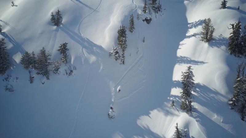
recent activity -Numerous shallow sled and board triggered wind slabs were reported from drifted upper elevation terrain in the Bear River Range over the weekend. The manageable soft slab avalanches usually occurred in expected drifted steep areas, and were about 8" deep and mostly 50' wide, but one was 120' wide and ran around 1000' vrt. -A party of skiers in Wood Camp Hollow reported sensitive wet avalanche conditions and triggered a few shallow sluffs on a sunny slope near rock outcroppings.
Aerial view of a shallow wind slab being triggered by a rider on 2/12/17 |
| type | aspect/elevation | characteristics |
|---|

|

|
LIKELIHOOD
 LIKELY
UNLIKELY
SIZE
 LARGE
SMALL
TREND
 INCREASING DANGER
SAME
DECREASING DANGER
|
|
description
Shallow wind slabs were quite sensitive over the weekend at upper elevations. The easily triggered and generally manageable soft slabs involving about 8" of fresh snow are running on a rain-crust from Friday's warm and wet storm. The main thing with this type of avalanche is to avoid being pushed into terrain traps like cliffs or trees below. |
| type | aspect/elevation | characteristics |
|---|

|

|
LIKELIHOOD
 LIKELY
UNLIKELY
SIZE
 LARGE
SMALL
TREND
 INCREASING DANGER
SAME
DECREASING DANGER
|
|
description
Heightened wet avalanche conditions exist on slopes with saturated snow. Solar warming will create an increasing danger of shallow loose wet avalanches on steep sunny slopes, and both triggered and natural sluffs are possible. These will entrain a few inches of moist new snow and run on the rain-crust. If you sink past your ankles into the wet snow, it's time get off and out from under steep slopes. Roller balls, pinwheels and wet sluffs are indicators of wet avalanche potential. |
 |
weather High pressure aloft will strengthen across the region during the midweek period. An active weather pattern is expected to redevelop late in the week through the upcoming weekend. Today will be mostly sunny, with a high temperature at 8500' near 37 F, and light north-northeast wind will become calm. Tonight will be mostly clear, with a low temperature of 22 F and 7 mph east-northeast wind. Tomorrow will be sunny with a high temperature of 38 F and 5 to 7 mph north wind. It'll be mostly clear with a low temperature of 24 and calm conditions on Tuesday night. |
| general announcements Any time is a great time to practice companion rescue techniques with your partners. Companion Rescue Practice Video Do you buy groceries at Smiths? When you register your Smith’s rewards card with their Community Rewards program, they will donate to the Utah Avalanche Center whenever you make a purchase. It's easy, only takes a minute, and doesn't cost you anything. Details here. If you sign up for AmazonSmile and designate the Utah Avalanche Center as your favorite charity, they will donate a portion of everything you spend to the UAC. It doesn't cost you a penny and we'd really appreciate the help. Discount lift tickets for Beaver Mountain, Snowbasin, Powder Mountain, and the Central Wasatch resorts are donated by the resorts to benefit the Utah Avalanche Center. Details and order information here. Your information can save lives. If you see anything we should know please help us out by submitting snow and avalanche observations. You can call us at 801-524-5304, email by clicking HERE, or include @utavy in your Instagram. In the Logan Area you can reach me at 435-757-7578 We will update this advisory regularly on Monday, Wednesday, Friday, and Saturday mornings by about 7:30. This advisory is from the U.S.D.A. Forest Service, which is solely responsible for its content. This advisory describes general avalanche conditions and local variations always exist. |