25th Annual Black Diamond Fall Fundraising Party
Thursday, September 13; 6:00-10:00 PM; Black Diamond Parking Lot
25th Annual Black Diamond Fall Fundraising Party
Thursday, September 13; 6:00-10:00 PM; Black Diamond Parking Lot
| Advisory: Logan Area Mountains | Issued by Toby Weed for Saturday - February 11, 2017 - 7:01am |
|---|


|
bottom line The danger is MODERATE and triggered avalanches are possible at all elevations. Cooler temperatures today will help solidify the warm saturated snow, but heightened wet avalanche conditions still exist on low and mid elevation slopes. Heavy snowfall and west winds yesterday caused a heightened danger of storm snow, cornice fall, and wind slab avalanches at upper and mid elevations. Evaluate snow and terrain carefully.
|
 |
current conditions Beaver Mountain reports 10" of new snow, a bit heavy and wet from yesterday, but drier and lighter density snow from last night on top. The 8400' Tony Grove Snotel reports 26 F and 6" of new snow with 1.3" SWE (Snow Water Equivalent). There's 110" of total snow containing 163% of average SWE . It's 20 F at the CSI Logan Peak weather station at 9700', and the wind is from the northwest at 7 mph. Heightened wet avalanche conditions exist at low and mid elevations, but cooling today and tonight will help to solidify the saturated snow. Storm snow, cornice fall, and wind slab avalanche problems exist at upper and mid-elevations. |
 |
recent activity
|
| type | aspect/elevation | characteristics |
|---|

|
|
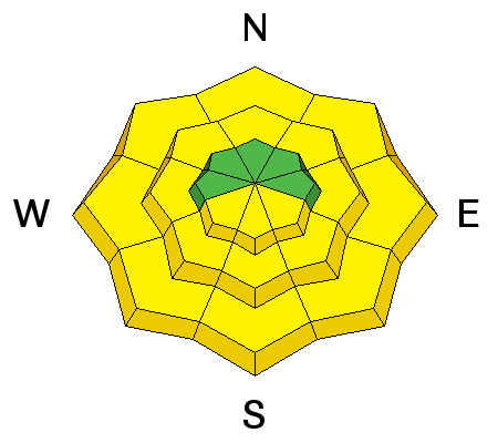
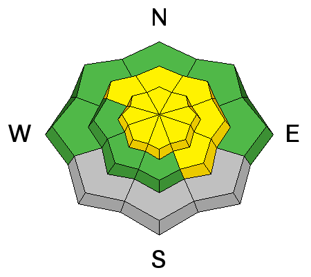
LIKELIHOOD
 LIKELY
UNLIKELY
SIZE
 LARGE
SMALL
TREND
 INCREASING DANGER
SAME
DECREASING DANGER
|
|
description
Heightened wet avalanche conditions exist on slopes with saturated snow. Cooler weather today will help matters, but a good freeze will wait till tonight, and temperatures should drop into the teens for a while. If you sink past your ankles into the wet snow, it's time to leave the area, or at least to get out from under steep slopes. Roller balls, pinwheels and wet sluffs are indicators of wet avalanche potential. Continue to stay off and out from under steep slopes with melt-softened wet snow. |
| type | aspect/elevation | characteristics |
|---|

|
|
LIKELIHOOD
LIKELY
UNLIKELY
SIZE
LARGE
SMALL
TREND
 INCREASING DANGER
SAME
DECREASING DANGER
|
description
|
 |
weather The moist Pacific storm system will move south of the Logan Zone and impact much of Utah through Saturday, then mainly southern Utah late in the weekend. High pressure will return for much of the upcoming week. Snow is likely in the mountains this morning, with 1/2 inch possible. It'll be cloudy in the morning, but gradually become mostly sunny in the afternoon, with a high temperature at 8500' of 31 F and 10 to 15 mph wind from the west-northwest. It'll be mostly clear tonight, with a low temperature of 17 F and 6 to 13 mph east-northeast wind. Tomorrow will be sunny, with a high temperature of 34 F and light east-northeast winds. Sunday night will be mostly clear, with a low temperature of 18 F and mostly calm conditions. |
| general announcements Any time is a great time to practice companion rescue techniques with your partners. Companion Rescue Practice Video Do you buy groceries at Smiths? When you register your Smith’s rewards card with their Community Rewards program, they will donate to the Utah Avalanche Center whenever you make a purchase. It's easy, only takes a minute, and doesn't cost you anything. Details here. If you sign up for AmazonSmile and designate the Utah Avalanche Center as your favorite charity, they will donate a portion of everything you spend to the UAC. It doesn't cost you a penny and we'd really appreciate the help. Discount lift tickets for Beaver Mountain, Snowbasin, Powder Mountain, and the Central Wasatch resorts are donated by the resorts to benefit the Utah Avalanche Center. Details and order information here. Your information can save lives. If you see anything we should know please help us out by submitting snow and avalanche observations. You can call us at 801-524-5304, email by clicking HERE, or include @utavy in your Instagram. In the Logan Area you can reach me at 435-757-7578 We will update this advisory regularly on Monday, Wednesday, Friday, and Saturday mornings by about 7:30. This advisory is from the U.S.D.A. Forest Service, which is solely responsible for its content. This advisory describes general avalanche conditions and local variations always exist. |


