25th Annual Black Diamond Fall Fundraising Party
Thursday, September 13; 6:00-10:00 PM; Black Diamond Parking Lot
25th Annual Black Diamond Fall Fundraising Party
Thursday, September 13; 6:00-10:00 PM; Black Diamond Parking Lot
| Advisory: Logan Area Mountains | Issued by Toby Weed for Friday - February 10, 2017 - 6:32am |
|---|

|
bottom line Warm temperatures and rain have created a CONSIDERABLE danger at all elevations in the backcountry. Dangerous wet avalanche conditions exist on steep slopes with saturated snow. Heavy snowfall and sustained westerly winds will create heightened storm snow, cornice fall, and wind slab avalanche conditions at upper and mid elevations. Carefully evaluate the snow, be conservative in decision making and route finding, avoid drifted terrain and stay out from under slopes with saturated snow.
|
 |
current conditions Temperatures are gradually dropping this morning after a warm, windy, and wet night in the mountains. Expect a stormy day today, with perhaps a foot of heavy snow at upper elevations and sustained west winds The 8400' Tony Grove Snotel reports 36 F and a half inch of rain in the last 6 hours. There's 105" of total snow containing 166% of average SWE (Snow Water Equivalent). It's 32 F at the CSI Logan Peak weather station at 9700', and the wind is from the southwest at 21 mph, gusting to 45 mph early this morning. Dangerous wet avalanche conditions exist at all elevations, but cooling with today's storm will help to solidify the saturated snow. Storm snow, cornice fall, and wind slab avalanche problems will develop at upper and mid-elevations as fresh snow stacks up and is drifted off the ridges and into avalanche starting zones.
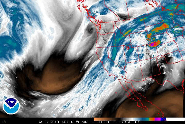
This morning's satellite water vapor image from NOAA shows the atmospheric fire-hose pointed our way again. |
 |
recent activity Heavy rain and warm temperatures tipped the scales at low elevations Tuesday. At least three natural loose wet avalanches hit and crossed Hwy 89 in the Dugway section of Logan Canyon starting about 12:30. The road was closed by the avalanches, but reopened late Wednesday morning. More natural wet avalanches occurred yesterday across the mountains of northern Utah and in Logan Canyon, including a repeater in the River Chutes below Temple Fork that built a temporary bridge across the river. |
| type | aspect/elevation | characteristics |
|---|

|

|
LIKELIHOOD
 LIKELY
UNLIKELY
SIZE
 LARGE
SMALL
TREND
 INCREASING DANGER
SAME
DECREASING DANGER
|
|
description
Dangerous wet avalanche conditions exist on slopes with saturated snow. Natural sluffs entraining loose wet snow are likely, and triggered wet slab avalanches are possible on mid and low elevation slopes with buried persistent weak layers. If you start sinking past your ankles into the wet snow, it's time to leave the area, or at least to get out from under steep slopes. Roller balls, pinwheels and wet sluffs are indicators of wet avalanche potential. Avoid and stay out from under steep slopes with melt-softened wet snow. |
| type | aspect/elevation | characteristics |
|---|

|

|
LIKELIHOOD
LIKELY
UNLIKELY
SIZE
 LARGE
SMALL
TREND
 INCREASING DANGER
SAME
DECREASING DANGER
|
description
|
 |
weather A moist Pacific storm will impact the region today, continuing through the weekend. High pressure aloft will return to the western states early next week. Rain will turn to snow in the mountains today as 8500' temperatures drop to 32 F by this evening. Sustained west winds of 20 to 30 mph with gusts of 40 mph will accompany the snow, with 9 to 13 inches possible by nightfall. Snow will continue tonight and 8500' temperatures will drop to 21 F. Breezy west winds will diminish from 25 mph to 10 to 15 mph overnight, with 2 to 4 inches of snow possible. Clearing will occur tomorrow, and it looks nice weather later this weekend, with sunny skies, moderate east winds, and a high temperature of 35 F at 8500' on Sunday. |
| general announcements Any time is a great time to practice companion rescue techniques with your partners. Companion Rescue Practice Video Do you buy groceries at Smiths? When you register your Smith’s rewards card with their Community Rewards program, they will donate to the Utah Avalanche Center whenever you make a purchase. It's easy, only takes a minute, and doesn't cost you anything. Details here. If you sign up for AmazonSmile and designate the Utah Avalanche Center as your favorite charity, they will donate a portion of everything you spend to the UAC. It doesn't cost you a penny and we'd really appreciate the help. Discount lift tickets for Beaver Mountain, Snowbasin, Powder Mountain, and the Central Wasatch resorts are donated by the resorts to benefit the Utah Avalanche Center. Details and order information here. Your information can save lives. If you see anything we should know please help us out by submitting snow and avalanche observations. You can call us at 801-524-5304, email by clicking HERE, or include @utavy in your Instagram. In the Logan Area you can reach me at 435-757-7578 We will update this advisory regularly on Monday, Wednesday, Friday, and Saturday mornings by about 7:30. This advisory is from the U.S.D.A. Forest Service, which is solely responsible for its content. This advisory describes general avalanche conditions and local variations always exist. |