25th Annual Black Diamond Fall Fundraising Party
Thursday, September 13; 6:00-10:00 PM; Black Diamond Parking Lot
25th Annual Black Diamond Fall Fundraising Party
Thursday, September 13; 6:00-10:00 PM; Black Diamond Parking Lot
| Advisory: Logan Area Mountains | Issued by Toby Weed for Tuesday - February 7, 2017 - 7:04am |
|---|


|
bottom line Rising avalanche danger: Dangerous wind slab avalanche conditions already exist at upper elevations, and increasing west-southwest winds along with continuing heavy snowfall are creating a HIGH danger on drifted slopes. Recent warm temperatures, expected rain, and already saturated snow are causing dangerous wet avalanche conditions at low elevations. Stay off and out from under slopes steeper than 30 degrees, avoid potential avalanche runouts and historic avalanche paths.
|
 |
avalanche warning THE FOREST SERVICE UTAH AVALANCHE CENTER IN SALT LAKE CITY HAS ISSUED A BACKCOUNTRY AVALANCHE WARNING. * TIMING…IN EFFECT FROM NOON TODAY TO 6 AM MST WEDNESDAY * AFFECTED AREA…FOR THE MOUNTAINS OF NORTHERN UTAH AND SE IDAHO INCLUDING THE WASATCH RANGE...WESTERN UINTA RANGE..BEAR RIVER RANGE...WELLSVILLE RANGE. * AVALANCHE DANGER…THE AVALANCHE DANGER FOR THE WARNING AREA IS HIGH. * IMPACTS…RAIN, HEAVY SNOWFALL, AND STRONG WINDS ARE CREATING UNSTABLE SNOW AT ALL ELEVATIONS. VERY DANGEROUS AVALANCHE CONDITIONS EXIST, NATURAL AVALANCHES ARE LIKELY. STAY OFF AND OUT FROM UNDER SLOPES STEEPER THAN 30 DEGREES, AVOID AVALANCHE RUN OUT ZONES. BACKCOUNTRY TRAVELERS SHOULD CONSULT WWW.UTAHAVALANCHECENTER.ORG OR CALL 1-888-999-4019 FOR MORE DETAILED INFORMATION. THIS WARNING DOES NOT APPLY TO SKI AREAS WHERE AVALANCHE HAZARD REDUCTION MEASURES ARE PERFORMED. |
 |
special announcement Thursday 2/9- This week the Utah Adventure Journal Speaker Series hosts professional ski-mountaineer Andrew McLean. Andrew has a PhD in mountain mistakes and will be sharing lessons learned from personal ski mountaineering experiences with avalanches, crevasses, long falls, getting lost, partner malfunctions and many other mountain mishaps. Andrew is the author of The Chuting Gallery and a veteran of over 25 skiing expeditions. For all event details click here. |
 |
current conditions A moist, warm, and windy Pacific storm will impact the zone today and cause a rising avalanche danger in the backcountry. Backcountry travel is not recommended, and if you want to enjoy the new snow you should consider riding the lifts. There's 11" of heavy new snow and it's 31 F this morning at Beaver Mountain. The 8400' Tony Grove Snotel reports 26 F and 9" of new snow with 2" SWE (Snow Water Equivalent) in the last 24 hours. There's 105" of total snow containing 160% of average SWE. It's 22 F at the CSI Logan Peak weather station at 9700', and the wind is from the southwest at 21 mph, gusting to 41 mph. |
 |
recent activity Several sizable natural loose wet avalanches hit the Logan River, and one crossed Hwy 89 in the Dugway section of Logan Canyon. Large natural wet avalanches occurred over the weekend at low elevations in various canyons across the Logan Zone. |
| type | aspect/elevation | characteristics |
|---|

|
|
LIKELIHOOD
 LIKELY
UNLIKELY
SIZE
 LARGE
SMALL
TREND
 INCREASING DANGER
SAME
DECREASING DANGER
|
|
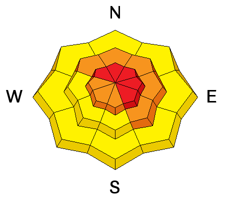
description
Drifting from strong southwest winds created fresh wind slabs and built out cornices in exposed terrain. The danger of wind slab avalanches will increase and become more widespread, with increasing west winds and heavy snowfall continuing during the day. Cornices could break further back than expected and may trigger avalanches on drifted slopes below. Storm slab avalanches entraining the heavy new snow are also possible in more sheltered terrain. |
| type | aspect/elevation | characteristics |
|---|

|
|
LIKELIHOOD
 LIKELY
UNLIKELY
SIZE
 LARGE
SMALL
TREND
INCREASING DANGER
SAME
DECREASING DANGER
|
|
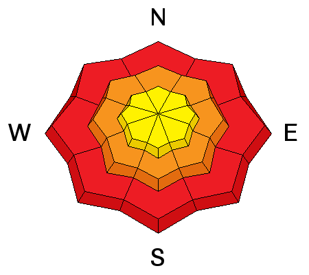
description
Dangerous wet avalanche conditions exist on slopes with saturated snow, and rain today below 7000' will only make matters worse. Snow will change back over to rain at lower elevations as temperatures rise during the day. Natural sluffs entraining loose wet snow are likely, and triggered wet slab avalanches are possible on slopes with buried persistent weak layers. Avoid and stay out from under steep slopes with wet snow. |
| type | aspect/elevation | characteristics |
|---|

|
|
LIKELIHOOD
LIKELY
UNLIKELY
SIZE
LARGE
SMALL
TREND
INCREASING DANGER
SAME
DECREASING DANGER
|
|
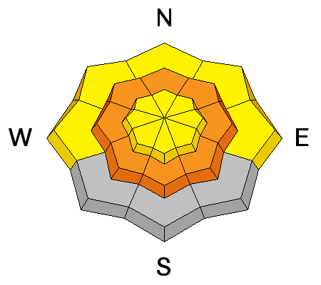
description
Triggered persistent slab avalanches around 2 feet deep are possible on mid-elevation slopes with buried persistent weak layers. The new load from today's heavy snow may activate the weak layers and dangerous conditions could develop.
|
 |
weather A warm and moist pacific system will impact mainly northern and central Utah and southwest Wyoming through Tuesday night. A stronger pacific trough is expected to impact all areas Friday through Saturday. |
| general announcements Any time is a great time to practice companion rescue techniques with your partners. Companion Rescue Practice Video Do you buy groceries at Smiths? When you register your Smith’s rewards card with their Community Rewards program, they will donate to the Utah Avalanche Center whenever you make a purchase. It's easy, only takes a minute, and doesn't cost you anything. Details here. If you sign up for AmazonSmile and designate the Utah Avalanche Center as your favorite charity, they will donate a portion of everything you spend to the UAC. It doesn't cost you a penny and we'd really appreciate the help. Discount lift tickets for Beaver Mountain, Snowbasin, Powder Mountain, and the Central Wasatch resorts are donated by the resorts to benefit the Utah Avalanche Center. Details and order information here. Your information can save lives. If you see anything we should know please help us out by submitting snow and avalanche observations. You can call us at 801-524-5304, email by clicking HERE, or include @utavy in your Instagram. In the Logan Area you can reach me at 435-757-7578 We will update this advisory regularly on Monday, Wednesday, Friday, and Saturday mornings by about 7:30. This advisory is from the U.S.D.A. Forest Service, which is solely responsible for its content. This advisory describes general avalanche conditions and local variations always exist. |


