25th Annual Black Diamond Fall Fundraising Party
Thursday, September 13; 6:00-10:00 PM; Black Diamond Parking Lot
25th Annual Black Diamond Fall Fundraising Party
Thursday, September 13; 6:00-10:00 PM; Black Diamond Parking Lot
| Advisory: Logan Area Mountains | Issued by Toby Weed for Monday - February 6, 2017 - 6:52am |
|---|

|
bottom line A moist, windy, and warm Pacific storm will cause rising avalanche danger. Dangerous wet avalanche conditions exist at low elevations due to warm temperatures, rain, and already saturated snow. Drifting from sustained and increasing south wind overnight created dangerous wind slab avalanche conditions in exposed upper elevation terrain, and the danger will continue to rise and become more widespread today. Carefully evaluate the snow, be conservative in decision making and route finding, avoid drifted terrain and stay out from under low elevation slopes with saturated snow.
|
 |
special announcement Do you buy groceries at Smiths? When you register your Smith’s rewards card with their Community Rewards program, they will donate to the Utah Avalanche Center whenever you make a purchase. It's easy, only takes a minute, and doesn't cost you anything. Details here. |
 |
current conditions Beaver Mountain reports 32 F and 2 inches of new snow. Yesterday, the Tony Grove Snotel reported 96" of total snow and 151% SWE (Snow Water Equivalent) It's 23 F at the CSI Logan Peak weather station at 9700', and the wind is from the southwest at 33 mph, gusting to 56 mph. The snow on low elevation slopes was soggy from warmth, and there were many natural avalanches at lower elevations over the weekend. A moist and windy Pacific storm will begin to impact the zone today and will cause a rising avalanche danger in the backcountry. Rain on already wet snow at low elevations will create dangerous conditions, and natural wet avalanches are possible in steep terrain. Up higher, strong south winds are drifting the heavy new snow and triggered wind slab avalanches are increasingly likely. |
 |
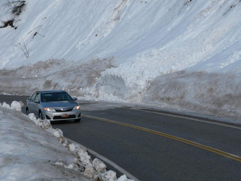
recent activity Several sizable natural loose wet avalanches hit the Logan River, and one crossed Hwy 89 in the Dugway section of Logan Canyon. Large natural wet avalanches occurred over the weekend at low elevations in various canyons across the Logan Zone.
A wet avalanche hit Logan Canyon Hwy 89 in the Dugway in the middle of the day on Saturday. |
| type | aspect/elevation | characteristics |
|---|

|

|
LIKELIHOOD
 LIKELY
UNLIKELY
SIZE
 LARGE
SMALL
TREND
 INCREASING DANGER
SAME
DECREASING DANGER
|
|
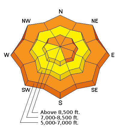
description
Dangerous wet avalanche conditions exist on slopes with saturated snow, and rain today below 6500' will not help the situation. Natural sluffs entraining loose wet snow are likely at lower elevations, and triggered wet slab avalanches are possible on slopes with buried persistent weak layers. Avoid and stay out from under steep slopes with wet snow. |
| type | aspect/elevation | characteristics |
|---|

|
|
LIKELIHOOD
LIKELY
UNLIKELY
SIZE
LARGE
SMALL
TREND
INCREASING DANGER
SAME
DECREASING DANGER
|
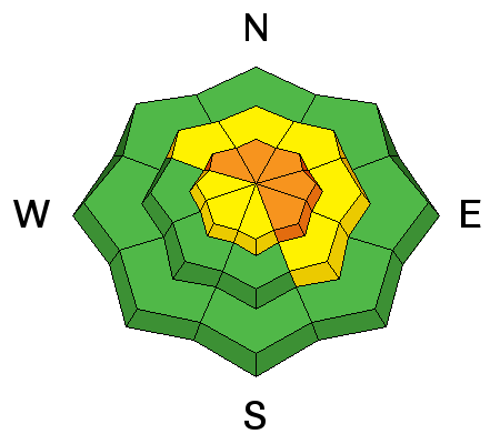
description
|
| type | aspect/elevation | characteristics |
|---|

|
|
LIKELIHOOD
 LIKELY
UNLIKELY
SIZE
LARGE
SMALL
TREND
INCREASING DANGER
SAME
DECREASING DANGER
|
|
description
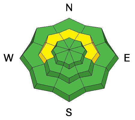
Triggered persistent slab avalanches around 2 feet deep are possible in isolated mid-elevation terrain.
|
 |
weather An active and rather wet pattern will continue into next weekend. Snow levels will mainly remain above 6500 feet through the work week. Temperatures will drop to 27 F at 8500' this afternoon, and it'll be quite windy, with west-southwest winds 31 to 36 mph gusting to 50 mph. 2 to 4 inches of snow is likely by evening. Temperatures will remain steady at 27 F tonight, southwest winds 20 to 30 mph with gusts to 45 mph are expected, and 6 to 10 inches of snow is possible. Snow will continue Tuesday and Tuesday night, with continuing southwest wind and another 7 to 13 inches of snow by Wednesday morning. |
| general announcements Any time is a great time to practice companion rescue techniques with your partners. Companion Rescue Practice Video If you sign up for AmazonSmile and designate the Utah Avalanche Center as your favorite charity, they will donate a portion of everything you spend to the UAC. It doesn't cost you a penny and we'd really appreciate the help. Discount lift tickets for Beaver Mountain, Snowbasin, Powder Mountain, and the Central Wasatch resorts are donated by the resorts to benefit the Utah Avalanche Center. Details and order information here. Your information can save lives. If you see anything we should know please help us out by submitting snow and avalanche observations. You can call us at 801-524-5304, email by clicking HERE, or include @utavy in your Instagram. In the Logan Area you can reach me at 435-757-7578 We will update this advisory regularly on Monday, Wednesday, Friday, and Saturday mornings by about 7:30. This advisory is from the U.S.D.A. Forest Service, which is solely responsible for its content. This advisory describes general avalanche conditions and local variations always exist. |