25th Annual Black Diamond Fall Fundraising Party
Thursday, September 13; 6:00-10:00 PM; Black Diamond Parking Lot
25th Annual Black Diamond Fall Fundraising Party
Thursday, September 13; 6:00-10:00 PM; Black Diamond Parking Lot
| Advisory: Logan Area Mountains | Issued by Toby Weed for Friday - February 3, 2017 - 6:48am |
|---|

|
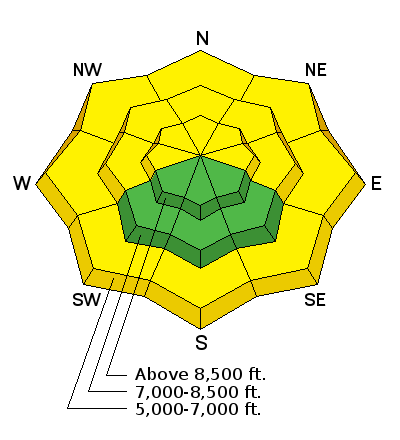
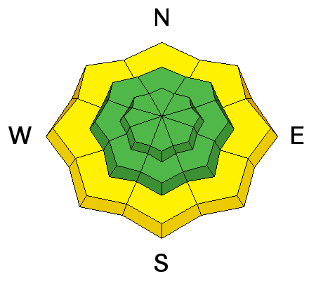
bottom line The danger is LOW on most slopes in the Logan Zone, but pockets of heightened avalanche conditions exist. Triggered persistent slab avalanches, 2' deep, are unlikely but possible on slopes with buried weak layers. Increasing southwest winds will cause a rising danger of wind slab avalanches in drifted terrain. Rain at lower elevations may cause a heightened danger of wet avalanches on steep slopes. Get up to the mountains for some fresh air, but evaluate snow and terrain carefully.
|
 |
special announcement Do you buy groceries at Smiths? When you register your Smith’s rewards card with their Community Rewards program, they will donate to the Utah Avalanche Center whenever you make a purchase. It's easy, only takes a minute, and doesn't cost you anything. Details here. |
 |
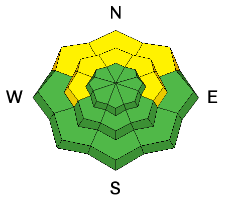
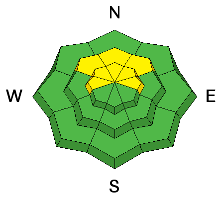
current conditions A weak Pacific storm system will begin to erode the entrenched inversion, and relief from the valley smog is headed our way. The 8400' Tony Grove Snotel reports 1 inch of new snow in the last 24 hrs. It's 28 F and there is 93" of total snow containing 149% of average SWE (Snow Water Equivalent.) It's 22 F at the CSI Logan Peak weather station at 9700', and the wind is from the south at 18 mph. The snow in the backcountry is stable in most places, but a scattering of unstable areas exist. Triggered avalanches, 2' deep, on buried surface hoar or facets capping a sun-crust are unlikely but possible on isolated mid-elevation slopes. Sustained southwest winds the past several days stripped snow off of windward slopes and created drifts at upper elevations. Most exposed slopes have wind-crust, sastrugi, or stiff wind slabs. Wind slab avalanches are possible to trigger in drifted terrain. South facing and low elevation slopes are crusty from sun or warmth, but rain at lower elevations could create heightened wet avalanche conditions on slopes with saturated snow.
NWS radar and satellite water vapor imagery from 2/3/17, showing the next wave of Pacific storminess to affect the region. Air quality in Cache Valley will improve during the next 24 hours. |
 |
recent activity It's been more than a week since any significant avalanches have been reported in the Logan Zone. |
| type | aspect/elevation | characteristics |
|---|

|
|
LIKELIHOOD
 LIKELY
UNLIKELY
SIZE
 LARGE
SMALL
TREND
 INCREASING DANGER
SAME
DECREASING DANGER
|
description
|
| type | aspect/elevation | characteristics |
|---|

|
|
LIKELIHOOD
LIKELY
UNLIKELY
SIZE
LARGE
SMALL
TREND
 INCREASING DANGER
SAME
DECREASING DANGER
|
description
|
| type | aspect/elevation | characteristics |
|---|

|
|
LIKELIHOOD
LIKELY
UNLIKELY
SIZE
LARGE
SMALL
TREND
INCREASING DANGER
SAME
DECREASING DANGER
|
|
description
Rain at low elevations may cause a heightened danger of wet avalanches. Avoid and stay out from under steep slopes with saturated snow. |
 |
weather The National Weather Service in Pocatello ID has issued a Winter Storm Warning for the mountains in Franklin and Bear Lake counties. A series of weak weather systems will cross the northern portions of the area through Saturday. The stormy pattern will continue into next week. Snow is likely this afternoon, with 1 to 2 inches likely. The high temperature at 8500' is expected to reach 33 F, and southwest winds will increase to 15 to 20 mph. Snow is likely tonight, with a temperature around 32 F, southwest winds 20 to 25 mph gusting to 40 mph, and 3 to 5 inches of snow. Snowfall and breezy conditions will continue tomorrow, with 2 to 4 inches of snow forecast, 29 F, and 20 to 25 mph west winds. |
| general announcements Any time is a great time to practice companion rescue techniques with your partners. Companion Rescue Practice Video If you sign up for AmazonSmile and designate the Utah Avalanche Center as your favorite charity, they will donate a portion of everything you spend to the UAC. It doesn't cost you a penny and we'd really appreciate the help. Discount lift tickets for Beaver Mountain, Snowbasin, Powder Mountain, and the Central Wasatch resorts are donated by the resorts to benefit the Utah Avalanche Center. Details and order information here. Your information can save lives. If you see anything we should know please help us out by submitting snow and avalanche observations. You can call us at 801-524-5304, email by clicking HERE, or include @utavy in your Instagram. In the Logan Area you can reach me at 435-757-7578 We will update this advisory regularly on Monday, Wednesday, Friday, and Saturday mornings by about 7:30. This advisory is from the U.S.D.A. Forest Service, which is solely responsible for its content. This advisory describes general avalanche conditions and local variations always exist. |


