25th Annual Black Diamond Fall Fundraising Party
Thursday, September 13; 6:00-10:00 PM; Black Diamond Parking Lot
25th Annual Black Diamond Fall Fundraising Party
Thursday, September 13; 6:00-10:00 PM; Black Diamond Parking Lot
| Advisory: Logan Area Mountains | Issued by Toby Weed for Monday - January 30, 2017 - 7:02am |
|---|

|
bottom line The snow is stable and avalanches are unlikely on most slopes, but heightened avalanche conditions exist in some areas, with triggered persistent slab, wind slab, and loose wet avalanches possible. Persistent slab avalanches, 2' deep, are possible at mid and lower elevations on slopes with buried surface hoar and in sunny terrain with buried facets above a sun-crust. Evaluate snow and terrain carefully, avoid steep drifted terrain and sunny slopes with saturated surface snow.
|
 |
special announcement Do you buy groceries at Smiths? When you register your Smith’s rewards card with their Community Rewards program, they will donate to the Utah Avalanche Center whenever you make a purchase. It's easy, only takes a minute, and doesn't cost you anything. Details here. |
 |
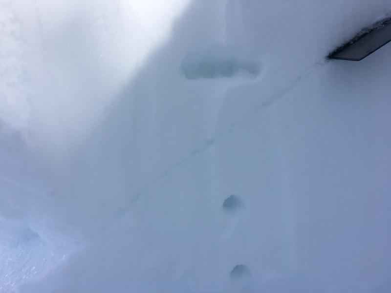
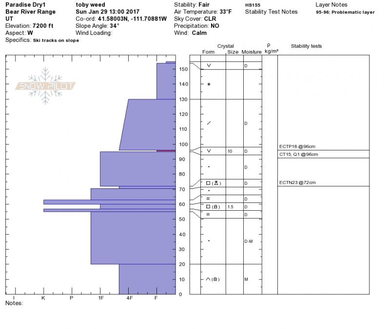
current conditions The 8400' Tony Grove Snotel reports 25 F and 99" of total snow containing 155% of average SWE (Snow Water Equivalent.) It's 25 F at the CSI Logan Peak weather station at 9700', and the wind is blowing from the southwest at 22 mph. You'll find much nicer weather, clean air, warmth, sunshine, and nice powder riding conditions in the mountains above the valley murk. South facing slopes are sun-affected and the snow surface is either crusty or saturated, but fine settled powder still exists on many slopes in the zone. Lots of people got out this weekend and no significant avalanches were reported. The snow appears stable in most places, but areas with unstable snow exist. Triggered avalanches, 2' deep, on buried surface hoar are possible on mid and lower elevation slopes. Collapses, cut-bank activity, and snowpit tests this weekend indicate avalanche potential. Over the weekend, I found poor snow structure with buried surface hoar and weak facets capping a sun-crust in sunnier areas at mid and lower elevations on west and southwest facing slopes in East Wood Camp in the the southern Bear River Range.
Poor snow structure and triggered avalanche potential exist on slopes with buried surface hoar or sugary facets capping a sun-crust. (1/29/17) |
 |
recent activity
Trent looks at a recent triggered avalanche in the Park City backcountry. The triggered persistent slab avalanche failed on facets capping a sun-crust on a east-southeast facing slope. |
| type | aspect/elevation | characteristics |
|---|

|
|
LIKELIHOOD
 LIKELY
UNLIKELY
SIZE
 LARGE
SMALL
TREND
 INCREASING DANGER
SAME
DECREASING DANGER
|
description
|
| type | aspect/elevation | characteristics |
|---|

|
|
LIKELIHOOD
LIKELY
UNLIKELY
SIZE
LARGE
SMALL
TREND
 INCREASING DANGER
SAME
DECREASING DANGER
|
|
description
Heightened wind slab avalanche conditions exist in drifted upper elevation terrain.
|
| type | aspect/elevation | characteristics |
|---|

|

|
LIKELIHOOD
LIKELY
UNLIKELY
SIZE
LARGE
SMALL
TREND
INCREASING DANGER
SAME
DECREASING DANGER
|
|
description
Solar warming will cause a heightened danger of loose wet avalanches during the middle of the day on sunny slopes in sheltered terrain. |
 |
weather A strong mid level ridge will remain in place across the region through midweek. A series of weak weather systems will cross the area late in the week through next weekend. Today: Mostly sunny, with a high near 33. West wind 14 to 18 mph. |
| general announcements Any time is a great time to practice companion rescue techniques with your partners. Companion Rescue Practice Video If you sign up for AmazonSmile and designate the Utah Avalanche Center as your favorite charity, they will donate a portion of everything you spend to the UAC. It doesn't cost you a penny and we'd really appreciate the help. Discount lift tickets for Beaver Mountain, Snowbasin, Powder Mountain, and the Central Wasatch resorts are donated by the resorts to benefit the Utah Avalanche Center. Details and order information here. Your information can save lives. If you see anything we should know please help us out by submitting snow and avalanche observations. You can call us at 801-524-5304, email by clicking HERE, or include @utavy in your Instagram. In the Logan Area you can reach me at 435-757-7578 We will update this advisory regularly on Monday, Wednesday, Friday, and Saturday mornings by about 7:30. This advisory is from the U.S.D.A. Forest Service, which is solely responsible for its content. This advisory describes general avalanche conditions and local variations always exist. |