25th Annual Black Diamond Fall Fundraising Party
Thursday, September 13; 6:00-10:00 PM; Black Diamond Parking Lot
25th Annual Black Diamond Fall Fundraising Party
Thursday, September 13; 6:00-10:00 PM; Black Diamond Parking Lot
| Advisory: Logan Area Mountains | Issued by Toby Weed for Wednesday - January 25, 2017 - 6:51am |
|---|

|
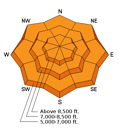
bottom line Dangerous avalanche conditions exist at all elevations in the backcountry, with triggered storm snow, persistent slab, and wind slab avalanches likely. Evaluate the snow carefully, make conservative decisions, and avoid steep drifted slopes.
|
 |
special announcement Do you buy groceries at Smiths? When you register your Smith’s rewards card with their Community Rewards program, they will donate to the Utah Avalanche Center whenever you make a purchase. It's easy, only takes a minute, and doesn't cost you anything. Details here. |
 |
current conditions Rapid accumulation of 2 to 3 feet of snow in the beginning of the week created dangerous avalanche conditions in the backcountry. Logan Canyon was closed due to avalanche danger Monday and reopened yesterday, but access to backcountry terrain was limited due to unplowed parking at the trail-heads and we've received no reports. Skiers and snowboarders apparently found fantastic deep powder conditions at Beaver Mountain yesterday. It's 10 F at the 8400' Tony Grove Snotel, and there's a couple inches of light new snow. The station reports over 2' of new snow since Sunday afternoon with 2.3" Snow Water Equivalent (SWE). There's 115" of total snow at the site containing 165% of average SWE. It's 4 F at the CSI Logan Peak weather station at 9700', and the wind sensor is encased by rime ice and not working. The wind is calm at the UDOT Hwy 89 Summit and southwest at 7 mph on Ogden Peak. |
 |
recent activity
|
| type | aspect/elevation | characteristics |
|---|

|
|
LIKELIHOOD
 LIKELY
UNLIKELY
SIZE
 LARGE
SMALL
TREND
 INCREASING DANGER
SAME
DECREASING DANGER
|
|
description
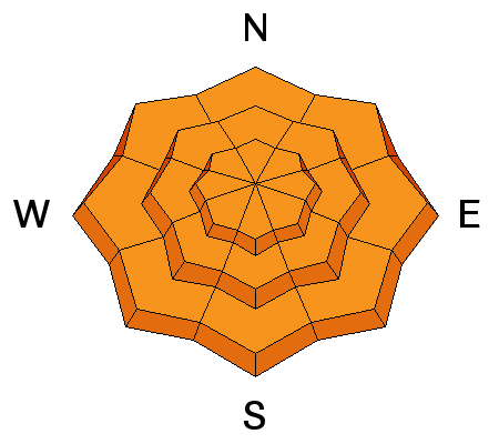
Long running loose sluffs and triggered storm slab avalanches, failing on density changes within the new snow, are likely in steep terrain at all elevations. |
| type | aspect/elevation | characteristics |
|---|

|

|
LIKELIHOOD
LIKELY
UNLIKELY
SIZE
LARGE
SMALL
TREND
INCREASING DANGER
SAME
DECREASING DANGER
|
description
|
| type | aspect/elevation | characteristics |
|---|

|
|
LIKELIHOOD
LIKELY
UNLIKELY
SIZE
LARGE
SMALL
TREND
 INCREASING DANGER
SAME
DECREASING DANGER
|
|
description
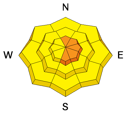
Dangerous wind slab avalanche conditions exist in drifted terrain.
|
 |
weather A cold northerly flow aloft will remain over the area through the end of the week. Strong high pressure aloft will lock in over the west coast states for late in the week, then expand east across the western states this weekend. 1 or 2 inches of snow is likely today, with an 8500' high temperature of 18 F and 10 to 15 mph west winds. 1 or 2 inches of snow is likely tonight with a low temperature of 7 F and moderate west wind. Tomorrow will be mostly cloudy with a high temperature of 17 F and 10 mph west-northwest wind. |
| general announcements Any time is a great time to practice companion rescue techniques with your partners. Companion Rescue Practice Video If you sign up for AmazonSmile and designate the Utah Avalanche Center as your favorite charity, they will donate a portion of everything you spend to the UAC. It doesn't cost you a penny and we'd really appreciate the help. Discount lift tickets for Beaver Mountain, Snowbasin, Powder Mountain, and the Central Wasatch resorts are donated by the resorts to benefit the Utah Avalanche Center. Details and order information here. Your information can save lives. If you see anything we should know please help us out by submitting snow and avalanche observations. You can call us at 801-524-5304, email by clicking HERE, or include @utavy in your Instagram. In the Logan Area you can reach me at 435-757-7578 We will update this advisory regularly on Monday, Wednesday, Friday, and Saturday mornings by about 7:30. This advisory is from the U.S.D.A. Forest Service, which is solely responsible for its content. This advisory describes general avalanche conditions and local variations always exist. |


