25th Annual Black Diamond Fall Fundraising Party
Thursday, September 13; 6:00-10:00 PM; Black Diamond Parking Lot
25th Annual Black Diamond Fall Fundraising Party
Thursday, September 13; 6:00-10:00 PM; Black Diamond Parking Lot
| Advisory: Logan Area Mountains | Issued by Toby Weed for Monday - January 23, 2017 - 6:55am |
|---|

|
bottom line Very dangerous avalanche conditions exist at all elevations in the backcountry. Natural storm snow and wind slab avalanches are likely with continuing heavy snow and sustained strong south winds today. Backcountry travel is not recommended. Stay off and out from under slopes steeper than 30 degrees. Avoid potential avalanche runouts, and historic avalanche paths.
|
 |
avalanche warning THE FOREST SERVICE UTAH AVALANCHE CENTER HAS ISSUED A BACKCOUNTRY AVALANCHE WARNING. * TIMING…IN EFFECT FROM 6 AM MST THIS MORNING TO 6 AM MST TUESDAY. * AFFECTED AREA…FOR THE MOUNTAINS OF NORTHERN UTAH INCLUDING THE WASATCH RANGE...BEAR RIVER RANGE...AND THE MOUNTAINS OF SOUTHEAST IDAHO * AVALANCHE DANGER…THE AVALANCHE DANGER FOR THE WARNING AREA IS HIGH TODAY. * IMPACTS…HEAVY DENSE SNOW COMBINED WITH STRONG WINDS HAS CREATED WIDESPREAD AREAS OF UNSTABLE SNOW AT ALL ELEVATIONS INCLUDING LOW ELEVATION TERRAIN. BOTH HUMAN TRIGGERED AND NATURAL AVALANCHES ARE LIKELY. STAY OFF OF AND OUT FROM UNDER SLOPES STEEPER THAN 30 DEGREES. BACKCOUNTRY TRAVELERS SHOULD CONSULT WWW.UTAHAVALANCHECENTER.ORG OR CALL 1-888-999-4019 FOR MORE DETAILED INFORMATION. THIS WARNING DOES NOT APPLY TO SKI AREAS WHERE AVALANCHE HAZARD REDUCTION MEASURES ARE PERFORMED. |
 |
special announcement If you sign up for AmazonSmile and designate the Utah Avalanche Center as your favorite charity, they will donate a portion of everything you spend to the UAC. It doesn't cost you a penny and we'd really appreciate the help. |
 |
current conditions Beaver Mountain reports 8" of snow in the last 24 hrs, but there's twice as much down here in Cache Valley. It's 18 F at the CSI Logan Peak weather station at 9700', with a 23 mph wind from the south-southeast, gusting to 36 mph. Heavy snow and south winds have created very dangerous avalanche conditions at all elevations in the backcountry, with natural avalanches likely or occurring. |
 |
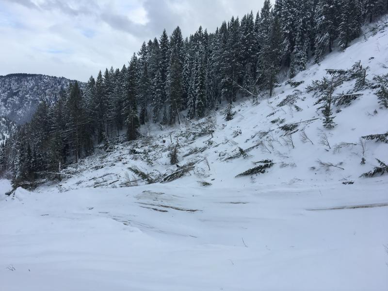
recent activity Riders report triggering fast running sluffs in steep terrain Saturday. No significant avalanches have been reported in the Logan Zone since the widespread, natural avalanche cycle on 1/11/17.
Large, natural avalanche from 1/11/17 in Wood Camp Hollow. |
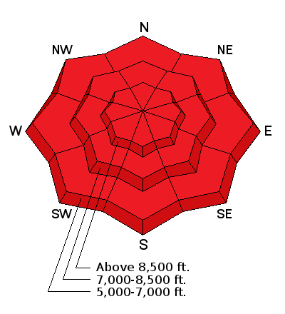
| type | aspect/elevation | characteristics |
|---|

|

|
LIKELIHOOD
 LIKELY
UNLIKELY
SIZE
 LARGE
SMALL
TREND
 INCREASING DANGER
SAME
DECREASING DANGER
|
description
|
| type | aspect/elevation | characteristics |
|---|

|
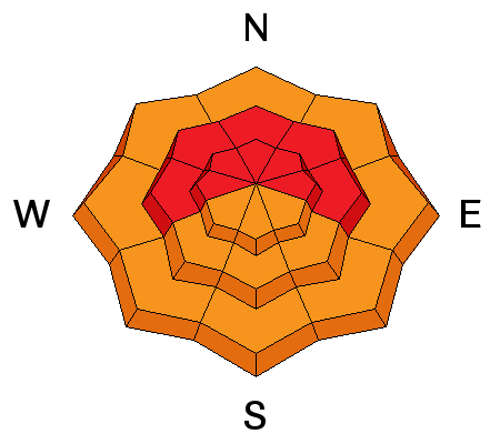
|
LIKELIHOOD
LIKELY
UNLIKELY
SIZE
LARGE
SMALL
TREND
INCREASING DANGER
SAME
DECREASING DANGER
|
|
description
Dangerous wind slab avalanche conditions exist in exposed upper and mid elevation terrain. Drifting from continuing southwest wind today will cause the danger to rise further and become more widespread.
|
| type | aspect/elevation | characteristics |
|---|

|
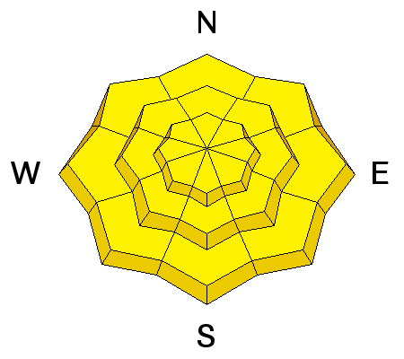
|
LIKELIHOOD
 LIKELY
UNLIKELY
SIZE
 LARGE
SMALL
TREND
INCREASING DANGER
SAME
DECREASING DANGER
|
|
description
Deep slab avalanches, failing on buried weak layers near the ground, are possible.
|
 |
weather The active weather pattern will continue across the region, with a series of weather systems crossing the area through the first half of the week. Heavy snow will continue today, with a foot or more possible by evening. Expect an 8500' high temperature of 29 F and 20 to 25 mph southwest winds with gusts to 40 mph. Snow will continue tonight, with 7 to 11 inches possible, low temperature of 13 F, and gradually decreasing 15 to 20 mph west winds. Snow will become showery tomorrow, with 1 to 3" of accumulation, a high temperature around 21 F and moderate northwest wind. |
| general announcements Any time is a great time to practice companion rescue techniques with your partners. Companion Rescue Practice Video Discount lift tickets for Beaver Mountain, Snowbasin, Powder Mountain, and the Central Wasatch resorts are donated by the resorts to benefit the Utah Avalanche Center. Details and order information here. Your information can save lives. If you see anything we should know please help us out by submitting snow and avalanche observations. You can call us at 801-524-5304, email by clicking HERE, or include @utavy in your Instagram. In the Logan Area you can reach me at 435-757-7578 We will update this advisory regularly on Monday, Wednesday, Friday, and Saturday mornings by about 7:30. This advisory is from the U.S.D.A. Forest Service, which is solely responsible for its content. This advisory describes general avalanche conditions and local variations always exist. |