25th Annual Black Diamond Fall Fundraising Party
Thursday, September 13; 6:00-10:00 PM; Black Diamond Parking Lot
25th Annual Black Diamond Fall Fundraising Party
Thursday, September 13; 6:00-10:00 PM; Black Diamond Parking Lot
| Advisory: Logan Area Mountains | Issued by Toby Weed for Sunday - January 22, 2017 - 7:10am |
|---|

|
bottom line Heightened avalanche conditions exist on drifted upper and mid-elevation slopes. Strengthening south wind will cause the danger to rise and become more widespread, and dangerous avalanche conditions will develop in exposed terrain by afternoon. Heavy snow and sustained southwest winds will cause the danger in the backcountry to rise further tonight and Monday. Evaluate the snow and terrain carefully, avoid steep drifted slopes, and make conservative decisions.
|
 |
special announcement If you sign up for AmazonSmile and designate the Utah Avalanche Center as your favorite charity, they will donate a portion of everything you spend to the UAC. It doesn't cost you a penny and we'd really appreciate the help. |
 |
current conditions The Tony Grove Snotel at 8400' reports 18 F and 9 inches of snow in the last 24 hrs. There is 96 inches of total snow containing 158% of average SWE (Snow Water Equivalent). It's 12 F at the CSI Logan Peak weather station at 9700', with a 7 mph south wind. Observers report nice powder riding yesterday, with lots of very light powder and much drifting at upper elevations. |
 |
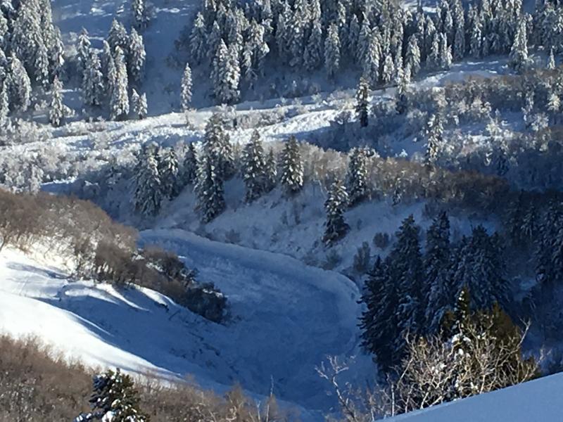
recent activity Riders report triggering fast running sluffs in steep terrain yesterday. No significant avalanches were reported in the Logan Zone since last week's widespread, natural avalanche cycle.
Large, natural avalanches from last week in the Wellsville Range above Mendon. |
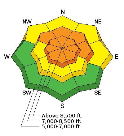
| type | aspect/elevation | characteristics |
|---|

|
|
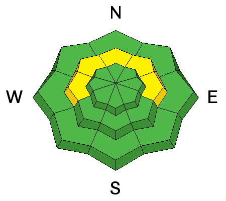
LIKELIHOOD
 LIKELY
UNLIKELY
SIZE
 LARGE
SMALL
TREND
 INCREASING DANGER
SAME
DECREASING DANGER
|
|
description
A heightened danger of wind slab avalanches already exists in exposed upper and mid elevation terrain. Drifting from intensifying southwest wind today will cause the danger to rise and become more widespread.
|
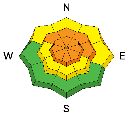
| type | aspect/elevation | characteristics |
|---|

|
|
LIKELIHOOD
LIKELY
UNLIKELY
SIZE
 LARGE
SMALL
TREND
INCREASING DANGER
SAME
DECREASING DANGER
|
description
|
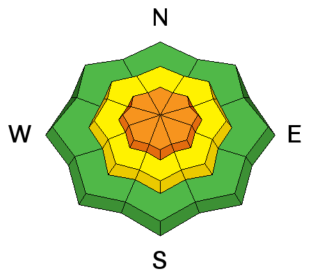
| type | aspect/elevation | characteristics |
|---|

|
|
LIKELIHOOD
 LIKELY
UNLIKELY
SIZE
 LARGE
SMALL
TREND
INCREASING DANGER
SAME
DECREASING DANGER
|
|
description
Deep slab avalanches, failing on buried weak layers, are unlikely but possible.
|
 |
weather The active weather pattern will continue across the region, with a series of weather systems crossing the area through the first half of the week. South winds will begin to increase significantly around midday. Expect a high temperature at 8500' around 29 degrees and 1 to 3" of snow is likely in the afternoon. It looks very snowy in the next couple days, with southwest wind and 2 to 3 feet of snow likely at upper elevations by Tuesday morning. |
| general announcements Any time is a great time to practice companion rescue techniques with your partners. Companion Rescue Practice Video Discount lift tickets for Beaver Mountain, Snowbasin, Powder Mountain, and the Central Wasatch resorts are donated by the resorts to benefit the Utah Avalanche Center. Details and order information here. Your information can save lives. If you see anything we should know please help us out by submitting snow and avalanche observations. You can call us at 801-524-5304, email by clicking HERE, or include @utavy in your Instagram. In the Logan Area you can reach me at 435-757-7578 We will update this advisory regularly on Monday, Wednesday, Friday, and Saturday mornings by about 7:30. This advisory is from the U.S.D.A. Forest Service, which is solely responsible for its content. This advisory describes general avalanche conditions and local variations always exist. |