25th Annual Black Diamond Fall Fundraising Party
Thursday, September 13; 6:00-10:00 PM; Black Diamond Parking Lot
25th Annual Black Diamond Fall Fundraising Party
Thursday, September 13; 6:00-10:00 PM; Black Diamond Parking Lot
| Advisory: Logan Area Mountains | Issued by Toby Weed for Friday - January 13, 2017 - 6:52am |
|---|

|
bottom line Dangerous avalanche conditions exist in the backcountry, and large triggered avalanches are likely. Give the new snow more time to stabilize before venturing onto steep slopes.
|
 |
current conditions The Tony Grove Snotel at 8400' reports 19 degrees F with 102 inches of total snow containing 179% of average SWE (Snow Water Equivalent). The station reports several feet of new snow and over 10 inches of SWE in the past week. It's 17 degrees F at the CSI Logan Peak weather station at 9700', and the wind sensor is rimed (or encased by ice). Winds at the UDOT Hwy 89 Logan Summit are easterly and light, 5 to 9 mph at 6:00 this morning. Dangerous avalanche conditions exist in the backcountry, with large triggered avalanches possible. |
 |
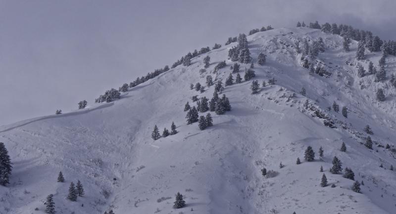
recent activity A natural avalanche hit Hwy 89 in the Beaver Canyon section of Logan Canyon just after noon Wednesday, closing the road until Thursday morning. Natural avalanche activity in the Wellsville Range was extensive in the past few days and HUGE fresh natural avalanches can be seen from across Cache Valley. Among the largest avalanches I've ever seen occurred on Mitton Peak above Hwy 89/91 in Sardine Canyon. Better visibility of the Bear River Range high country today and tomorrow should allow us to better see the extent of the natural cycle across the zone.
Mitton Peak Avalanche, 1/12/2017
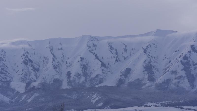
Large natural avalanches crashed down onto Maple Bench above Mendon during this week's storm. (1/12/17) |
| type | aspect/elevation | characteristics |
|---|

|
|
LIKELIHOOD
 LIKELY
UNLIKELY
SIZE
 LARGE
SMALL
TREND
 INCREASING DANGER
SAME
DECREASING DANGER
|
|
description
Persistent slab avalanches, failing on buried weak layers, are likely on many slopes.
|
| type | aspect/elevation | characteristics |
|---|

|
|
LIKELIHOOD
LIKELY
UNLIKELY
SIZE
 LARGE
SMALL
TREND
 INCREASING DANGER
SAME
DECREASING DANGER
|
description
|
| type | aspect/elevation | characteristics |
|---|

|

|
LIKELIHOOD
LIKELY
UNLIKELY
SIZE
 LARGE
SMALL
TREND
 INCREASING DANGER
SAME
DECREASING DANGER
|
|
description
We picked up a ridiculous amount of new snow in the past couple days and over 10" of SWE. Dry sluffs entraining the new snow are likely on steep slopes and could pick up significant piles of loose snow. Solar warming may cause a heightened danger of loose wet avalanches on sunny low and mid elevation slopes |
 |
weather A drying trend and a weak high pressure moving over the zone will lead to quiet weather, fairly cold temperatures, and sunny skies for the weekend before an active pattern redevelops by the middle of the week. It'll be partly sunny today with a high temperatures at 8500' of 26 degrees F. Light easterly winds will become calm this afternoon. Expect mostly cloudy skies tonight with light and variable winds and a steady 19 degree F temperature. Looks like mostly sunny conditions on Saturday, with a high of 28 degrees F and light southwest wind. Sunny skies will persist through MLK Day, with daytime highs in the mid twenties and nighttime lows in the mid teens. The next Pacific storm will begin to affect the zone on Wednesday. |
| general announcements The early season is a great time to practice companion rescue techniques with your partners. Companion Rescue Practice Video The National Avalanche Center just released their Avalanche Problems Explained video... Not all avalanches are made the same. As a result, travel and decisions in avalanche terrain are influenced by the kind of avalanche you expect to encounter. Watch HERE Check out Avalanche Canada's "Rescue at Cherry Bowl" story HERE Discount lift tickets for Beaver Mountain, Snowbasin, Powder Mountain, and the Central Wasatch resorts are donated by the resorts to benefit the Utah Avalanche Center. Details and order information here. Between now and Jan 15th: Donate to the Utah Avalanche Center by shopping at Whole Foods Market Utah! When you visit any Utah Whole Foods Market locations, bring your re-usable bags, Whole Foods will donate a dime per bag to the Utah Avalanche Center - if you say DONATE my bag credit. Your information can save lives. If you see anything we should know please help us out by submitting snow and avalanche observations. You can call us at 801-524-5304, email by clicking HERE, or include @utavy in your Instagram. In the Logan Area you can reach me at 435-757-7578 We will update this advisory regularly on Monday, Wednesday, Friday, and Saturday mornings by about 7:30. This advisory is from the U.S.D.A. Forest Service, which is solely responsible for its content. This advisory describes general avalanche conditions and local variations always exist. |