25th Annual Black Diamond Fall Fundraising Party
Thursday, September 13; 6:00-10:00 PM; Black Diamond Parking Lot
25th Annual Black Diamond Fall Fundraising Party
Thursday, September 13; 6:00-10:00 PM; Black Diamond Parking Lot
| Advisory: Logan Area Mountains | Issued by Toby Weed for Thursday - January 12, 2017 - 6:52am |
|---|

|
bottom line Very dangerous avalanche conditions exist, and large avalanches are likely. Give the new snow time to stabilize. Stay off and out from under slopes steeper than 30 degrees in the backcountry. Avoid potential avalanche runouts, and historic avalanche paths.
|
 |
avalanche warning THE FOREST SERVICE UTAH AVALANCHE CENTER IN SALT LAKE CITY HAS ISSUED A BACKCOUNTRY AVALANCHE WARNING. * TIMING...THE WARNING REMAINS IN EFFECT THROUGH 6 AM MST FRIDAY. * AFFECTED AREA...THE MOUNTAINS OF NORTHERN UTAH TO INCLUDE...THE WASATCH RANGE...THE BEAR RIVER RANGE...THE MOUNTAINS OF SOUTHEAST IDAHO...THE WESTERN UNITAS...AND THE MANTI-SKYLINE PLATEAU. * AVALANCHE DANGER...THE AVALANCHE DANGER REMAINS HIGH. * REASON/IMPACTS...NUMEROUS DAYS OF HEAVY SNOWFALL AND STRONG WINDS HAVE CREATED WIDESPREAD AVALANCHE DANGER. BOTH HUMAN TRIGGERED AND NATURAL AVALANCHES ARE LIKELY. STAY OFF OF AND OUT FROM UNDER SLOPES STEEPER THAN 30 DEGREES. BACKCOUNTRY TRAVELERS SHOULD CONSULT WWW.UTAHAVALANCHECENTER.ORG OR CALL 1-888-999-4019 FOR MORE DETAILED INFORMATION. THIS WARNING DOES NOT APPLY TO SKI AREAS WHERE AVALANCHE HAZARD REDUCTION MEASURES ARE PERFORMED. |
 |
current conditions The Tony Grove Snotel at 8400' reports 16 degrees F with 18" of new snow and 2.8" SWE (Snow Water Equivalent) in the last 24 hours. The station reports over 10 inches of SWE in the past week, and there's 107" of total snow containing 184% of average water for the date. It's 11 degrees F at the CSI Logan Peak weather station at 9700', and the wind sensor is rimed (or encased by ice). Winds at the UDOT Hwy 89 Logan Summit decreased significantly overnight, with northwest winds less than 10 mph. Very dangerous avalanche conditions exist in the backcountry, with large triggered avalanches likely and naturals possible. Avoid travel in avalanche terrain. A natural avalanche hit Hwy 89 in the Beaver Canyon section of Logan Canyon just after noon yesterday, and the highway remains closed this morning. UDOT is doing avalanche reduction work, cleaning up and assessing the situation this morning, and will reopen the Canyon as soon as possible. |
 |
recent activity With a brief clearing Monday evening I could see evidence of a natural avalanche cycle on the east side of the Wellsville Range. Large natural avalanches occurred in the Wellsville Mountain Wilderness in Pine Canyon, and the avalanche in Gibson Canyon hit Maple Bench pretty hard after running around 2600 vrt'. Natural activity in the Wellsville Range continued yesterday, with a large avalanche, visible from across Cache Valley, reported in Hells Canyon. Better visibility of the high country today and tomorrow should allow us to see the extent of the natural cycle across the zone. |
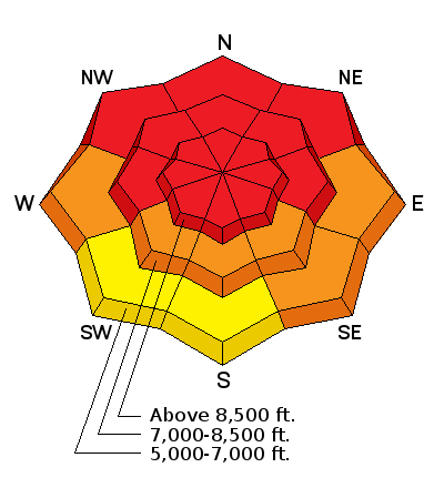
| type | aspect/elevation | characteristics |
|---|

|
|
LIKELIHOOD
 LIKELY
UNLIKELY
SIZE
 LARGE
SMALL
TREND
 INCREASING DANGER
SAME
DECREASING DANGER
|
|
description
Dangerous wind slab avalanche conditions exist in drifted terrain, especially at upper elevations. Sustained and gusty southwest winds for the past few days, during periods of heavy snowfall, have deposited feet of heavy drifted snow into lee slope avalanche starting zones. Large natural wind slab avalanches are likely. |
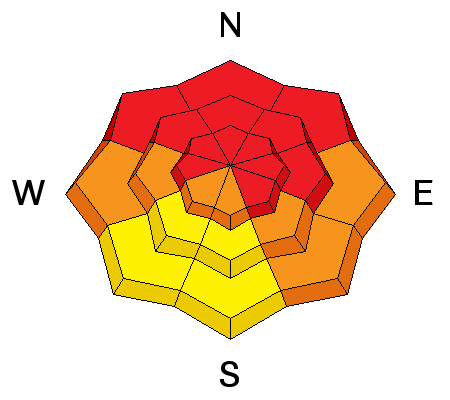
| type | aspect/elevation | characteristics |
|---|

|
|
LIKELIHOOD
LIKELY
UNLIKELY
SIZE
LARGE
SMALL
TREND
INCREASING DANGER
SAME
DECREASING DANGER
|
|
description
Storm slab avalanches, including the copious new snow are likely today, and these may occur in more sheltered areas. We picked up a ridiculous amount of new snow in the past couple days and over 10" of SWE. Soft storm slab avalanches involving the new snow could be well-connected and quite large. |
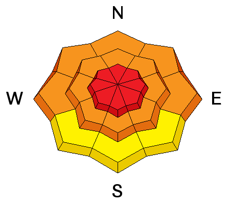
| type | aspect/elevation | characteristics |
|---|

|
|
LIKELIHOOD
LIKELY
UNLIKELY
SIZE
 LARGE
SMALL
TREND
 INCREASING DANGER
SAME
DECREASING DANGER
|
|
description
Persistent slab avalanches, failing on buried weak layers, are likely on many slopes.
|
 |
weather A low pressure system moving south along the west coast will bring one final round of precipitation to much of Utah today and tomorrow. High pressure aloft will then settle over the region for latter half of the weekend. The next stormy period looks to be towards the middle of next week. It'll be mostly cloudy in the mountains today, with high temperatures at 8500' of 23 degrees F, and light and variable winds becoming east-southeast in the afternoon. Some snow is possible in the afternoon, but little accumulation is expected. Mostly cloudy conditions are expected tonight, with a low temperature around 13 degrees F and 5 to 7 mph northeast winds. Should be mostly sunny, with a high of 23 degrees F and light northeast winds becoming calm in the afternoon. |
| general announcements The early season is a great time to practice companion rescue techniques with your partners. Companion Rescue Practice Video The National Avalanche Center just released their Avalanche Problems Explained video... Not all avalanches are made the same. As a result, travel and decisions in avalanche terrain are influenced by the kind of avalanche you expect to encounter. Watch HERE Check out Avalanche Canada's "Rescue at Cherry Bowl" story HERE Discount lift tickets for Beaver Mountain, Snowbasin, Powder Mountain, and the Central Wasatch resorts are donated by the resorts to benefit the Utah Avalanche Center. Details and order information here. Between now and Jan 15th: Donate to the Utah Avalanche Center by shopping at Whole Foods Market Utah! When you visit any Utah Whole Foods Market locations, bring your re-usable bags, Whole Foods will donate a dime per bag to the Utah Avalanche Center - if you say DONATE my bag credit. Your information can save lives. If you see anything we should know please help us out by submitting snow and avalanche observations. You can call us at 801-524-5304, email by clicking HERE, or include @utavy in your Instagram. In the Logan Area you can reach me at 435-757-7578 We will update this advisory regularly on Monday, Wednesday, Friday, and Saturday mornings by about 7:30. This advisory is from the U.S.D.A. Forest Service, which is solely responsible for its content. This advisory describes general avalanche conditions and local variations always exist. |


