25th Annual Black Diamond Fall Fundraising Party
Thursday, September 13; 6:00-10:00 PM; Black Diamond Parking Lot
25th Annual Black Diamond Fall Fundraising Party
Thursday, September 13; 6:00-10:00 PM; Black Diamond Parking Lot
| Advisory: Logan Area Mountains | Issued by Toby Weed for Wednesday - January 11, 2017 - 6:34am |
|---|

|
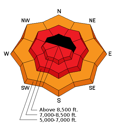
bottom line The avalanche danger may be EXTREME on some drifted upper elevation slopes. Very dangerous conditions exist, and large natural avalanches are likely. Stay off and out from under all slopes steeper than 30 degrees in the backcountry. Avoid potential avalanche runouts, and historic avalanche paths.
|
 |
avalanche warning THE FOREST SERVICE UTAH AVALANCHE CENTER IN SALT LAKE CITY HAS CONTINUED A BACKCOUNTRY AVALANCHE WARNING. * TIMING…THROUGH 6PM WEDNESDAY * AFFECTED AREA…THE MOUNTAINS OF NORTHERN UTAH, TO INCLUDE THE WASATCH RANGE, THE BEAR RIVER RANGE AND THE MOUNTAINS OF SOUTHEAST IDAHO, THE WESTERN UINTAS, AND THE MANTI-SKYLINE PLATEAU. * AVALANCHE DANGER…THE DANGER IS HIGH * IMPACTS…HEAVY SNOWFALL AND STRONG WINDS, COMBINED WITH RAIN ON SNOW AT THE LOWER ELEVATIONS WILL CREATE WIDESPREAD DANGEROUS AVALANCHE CONDITIONS. AVOID BEING ON OR BENEATH STEEP SLOPES. BACKCOUNTRY TRAVELERS SHOULD CONSULT WWW.UTAHAVALANCHECENTER.ORG OR CALL 1-888-999-4019 FOR MORE DETAILED INFORMATION. THIS WARNING DOES NOT APPLY TO SKI AREAS WHERE AVALANCHE HAZARD REDUCTION MEASURES ARE PERFORMED. |
 |
special announcement A sad day to remember. Twenty years ago today, on 1/11/1997, three experienced and well loved local backcountry skiers, Max Lyon, Karl Mueggler, and Keith Maas were killed by an avalanche while they slept in a tent in Logan Dry Canyon. The horrible accident stunned the Logan backcountry community and remains clear in the memories of many. http://articles.latimes.com/1997-01-16/news/mn-19147_1_susan-lyon |
 |
current conditions The Tony Grove Snotel at 8400' reports 27 degrees F with 18" of new snow and 3.1" SWE (Snow Water Equivalent) in the last 24 hours and 5.5" in the last 48. The station reports 9.5 inches of SWE in the past week, and there's 101" of total snow containing 170% of average water for the date. It's 20 degrees F at the CSI Logan Peak weather station at 9700', with 22 mph southwest winds gusting to 50 mph. Southwest winds appear to be slacking off a bit this morning after posting several hours with 35 mph average wind speeds last night. Very dangerous avalanche conditions exist at upper and mid elevations, with large natural avalanches likely. Avoid travel in avalanche terrain today. |
 |
recent activity Natural wet activity was widespread at lower elevations Monday, with loose wet and wet slab activity observed in Logan Canyon. With a brief clearing Monday evening I could see evidence of a natural avalanche cycle on the east side of the Wellsville Range. Large natural avalanches occurred in the Wellsville Mountain Wilderness in Pine Canyon, and the avalanche in Gibson Canyon hit Maple Bench pretty hard after running around 2600 vrt'. |
| type | aspect/elevation | characteristics |
|---|

|
|
LIKELIHOOD
 LIKELY
UNLIKELY
SIZE
 LARGE
SMALL
TREND
 INCREASING DANGER
SAME
DECREASING DANGER
|
|
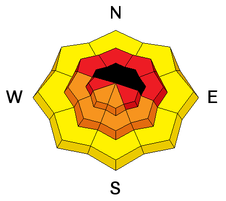
description
Very dangerous wind slab avalanche conditions exist in drifted terrain. Sustained and gusty southwest winds for the past few days during periods of heavy snowfall have deposited feet of heavy drifted snow into lee slope avalanche starting zones. Large natural wind slab avalanches are likely or occurring today. |
| type | aspect/elevation | characteristics |
|---|

|
|
LIKELIHOOD
 LIKELY
UNLIKELY
SIZE
LARGE
SMALL
TREND
 INCREASING DANGER
SAME
DECREASING DANGER
|
|
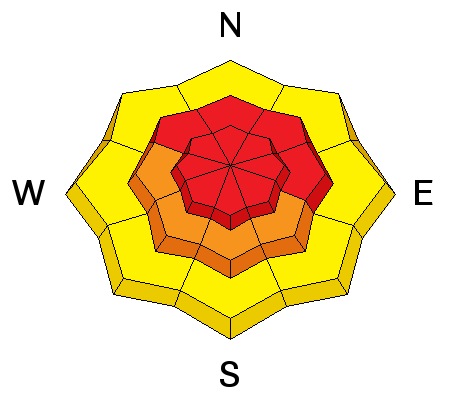
description
Storm slab avalanches, including the heavy new snow are likely today, and these may occur in more sheltered areas. We picked up a ridiculous amount of new snow in the past couple days and almost 10" of SWE. Soft storm slab avalanches involving the new snow could be well connected and quite large. |
| type | aspect/elevation | characteristics |
|---|

|
|
LIKELIHOOD
LIKELY
UNLIKELY
SIZE
 LARGE
SMALL
TREND
INCREASING DANGER
SAME
DECREASING DANGER
|
|
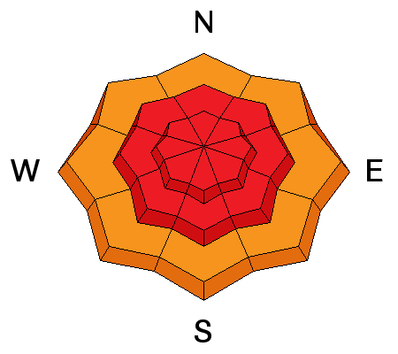
description
Persistent slab avalanches, failing on buried weak layers, are likely on many slopes.
|
 |
weather The next eastern Pacific trough will track east across the Great Basin today. One final disturbance will impact the south tomorrow into Friday, followed by high pressure for the weekend. Expect very stormy conditions today, with heavy snow, thunder, dropping temperatures and sustained strong and gusty west-southwest winds. Temperatures will drop to 23 degrees F at 8500', and 9 to 13 inches of additional snow is possible by evening. The winds should veer from the northwest tonight and diminish into the 15 to 25 mph range, 8500' temperatures will drop to 13 degrees F, and snowfall will taper off, with 4 to 8 inches possible. |
| general announcements The early season is a great time to practice companion rescue techniques with your partners. Companion Rescue Practice Video The National Avalanche Center just released their Avalanche Problems Explained video... Not all avalanches are made the same. As a result, travel and decisions in avalanche terrain are influenced by the kind of avalanche you expect to encounter. Watch HERE Check out Avalanche Canada's "Rescue at Cherry Bowl" story HERE Discount lift tickets for Beaver Mountain, Snowbasin, Powder Mountain, and the Central Wasatch resorts are donated by the resorts to benefit the Utah Avalanche Center. Details and order information here. Between now and Jan 15th: Donate to the Utah Avalanche Center by shopping at Whole Foods Market Utah! When you visit any Utah Whole Foods Market locations, bring your re-usable bags, Whole Foods will donate a dime per bag to the Utah Avalanche Center - if you say DONATE my bag credit. Your information can save lives. If you see anything we should know please help us out by submitting snow and avalanche observations. You can call us at 801-524-5304, email by clicking HERE, or include @utavy in your Instagram. In the Logan Area you can reach me at 435-757-7578 We will update this advisory regularly on Monday, Wednesday, Friday, and Saturday mornings by about 7:30. This advisory is from the U.S.D.A. Forest Service, which is solely responsible for its content. This advisory describes general avalanche conditions and local variations always exist. |


