25th Annual Black Diamond Fall Fundraising Party
Thursday, September 13; 6:00-10:00 PM; Black Diamond Parking Lot
25th Annual Black Diamond Fall Fundraising Party
Thursday, September 13; 6:00-10:00 PM; Black Diamond Parking Lot
| Advisory: Logan Area Mountains | Issued by Toby Weed for Monday - January 9, 2017 - 6:57am |
|---|

|
bottom line There is a HIGH avalanche danger at all elevations in the backcountry, and large natural avalanches are likely. Wet avalanches are likely in low elevation terrain, and snow and ice fall from roofs is occurring and will continue today in Cache Valley. Stay off and out from under all slopes steeper than 30 degrees. Avoid potential avalanche runouts, and historic avalanche paths.
|
 |
avalanche warning THE FOREST SERVICE UTAH AVALANCHE CENTER IN SALT LAKE CITY HAS CONTINUED A BACKCOUNTRY AVALANCHE WARNING. * TIMING…THROUGH 6PM WEDNESDAY * AFFECTED AREA…THE MOUNTAINS OF NORTHERN UTAH, TO INCLUDE THE WASATCH RANGE, THE BEAR RIVER RANGE AND THE MOUNTAINS OF SOUTHEAST IDAHO, THE WESTERN UINTAS, AND THE MANTI-SKYLINE PLATEAU. * AVALANCHE DANGER…THE DANGER IS HIGH * IMPACTS…HEAVY SNOWFALL AND STRONG WINDS, COMBINED WITH RAIN ON SNOW AT THE LOWER ELEVATIONS WILL CREATE WIDESPREAD DANGEROUS AVALANCHE CONDITIONS. AVOID BEING ON OR BENEATH STEEP SLOPES. AVALANCHES RELEASING OFF STEEP ROOFS MAY BE DANGEROUS IN THE URBAN AND MOUNTAIN VALLEYS. BACKCOUNTRY TRAVELERS SHOULD CONSULT WWW.UTAHAVALANCHECENTER.ORG OR CALL 1-888-999-4019 FOR MORE DETAILED INFORMATION. THIS WARNING DOES NOT APPLY TO SKI AREAS WHERE AVALANCHE HAZARD REDUCTION MEASURES ARE PERFORMED. |
 |
current conditions The Tony Grove Snotel at 8400' reports 32 degrees F with 4" of new snow and 1.3" SWE (Snow Water Equivalent) in the last 24 hours. There's 71" of total snow containing 136% of average SWE. It's 26 degrees F at the CSI Logan Peak weather station at 9700', with 34 mph south winds gusting to 67 mph. South winds whistled along the ridges overnight, cranking out 40 to 50 mph average wind speeds for 6 hours, and strong southwest winds will continue along with heavy snowfall throughout the day. Warm temperatures and rain at lower elevations have created serious problems for residents of Cache Valley. Officials are warning of significant potential for flooding, and rain-on-snow has caused a HIGH danger of wet avalanches at low elevations. Wet avalanches are likely or occurring today, potentially threatening snow bikers, runners, dog walkers, fishermen, and children innocently playing in the snow. One of our biggest concerns with the warmth and rain is the potential for roof avalanches down in the valley. Many roofs avalanched overnight and more will release their loads today. Watch out for snow and ice falling off buildings and don't let the kids play where snow from the roof could slide down on top of them. |
 |
recent activity Snow turned to rain yesterday afternoon in lower Logan Canyon and the rain/snow line climbed in elevation through the evening hours. Observers noted a few natural loose wet and soft slab avalanches yesterday evening in Logan Canyon. Roof avalanches occurred overnight, and more snow and ice falls from buildings are likely today. |
| type | aspect/elevation | characteristics |
|---|

|
|
LIKELIHOOD
 LIKELY
UNLIKELY
SIZE
 LARGE
SMALL
TREND
 INCREASING DANGER
SAME
DECREASING DANGER
|
|
description
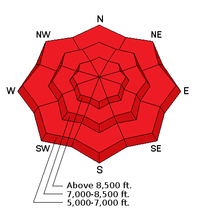
Very dangerous wind slab avalanche conditions exist on drifted upper and mid elevation slopes, and the danger will continue to increase as strong south winds veer from the west during the day. Natural and triggered wind slab avalanches are likely on drifted slopes steeper than 30 degrees. The avalanche danger could rise to EXTREME on some drifted upper elevation slopes. |
| type | aspect/elevation | characteristics |
|---|

|
|
LIKELIHOOD
LIKELY
UNLIKELY
SIZE
LARGE
SMALL
TREND
INCREASING DANGER
SAME
DECREASING DANGER
|
|
description
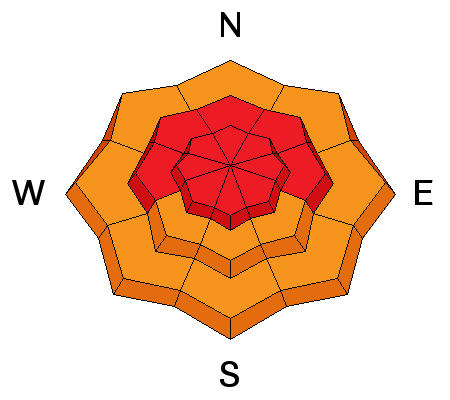
Persistent slab avalanches, failing on buried weak layers, are likely on many slopes.
|
| type | aspect/elevation | characteristics |
|---|

|

|
LIKELIHOOD
LIKELY
UNLIKELY
SIZE
LARGE
SMALL
TREND
 INCREASING DANGER
SAME
DECREASING DANGER
|
|
description
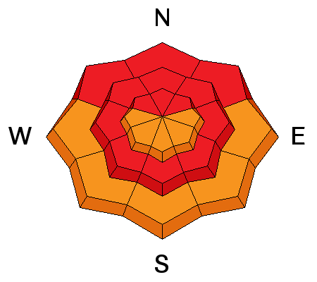
Warm rain on cold snow is never a good thing, and it has created very dangerous conditions at lower elevations. Soft low elevation snow is now saturated, and natural wet avalanches are likely. Avoid being under slopes steeper than about 30 degrees in the canyons and foothills, and watch for roof avalanches. A drop in temperatures later today and tonight should help to stabilize the saturated snow. |
 |
weather An active pattern will develop across the region with several storms expected to bring precipitation to the area through at least Friday. Temperatures will warm significantly early this week as warmer air spreads over the Great Basin. Temperatures at 8500' will drop into the mid twenties F by evening, and west-southwest winds will continue to crank out sustained 35 mph average wind speeds. Snowfall will be heavy this morning and become showery in the afternoon, with 8 to 12 inches of accumulation possible by evening. Looks like significant snow and strong west and southwest winds will continue through at least Wednesday Night. |
| general announcements The early season is a great time to practice companion rescue techniques with your partners. Companion Rescue Practice Video The National Avalanche Center just released their Avalanche Problems Explained video... Not all avalanches are made the same. As a result, travel and decisions in avalanche terrain are influenced by the kind of avalanche you expect to encounter. Watch HERE Check out Avalanche Canada's "Rescue at Cherry Bowl" story HERE Discount lift tickets for Beaver Mountain, Snowbasin, Powder Mountain, and the Central Wasatch resorts are donated by the resorts to benefit the Utah Avalanche Center. Details and order information here. Between now and Jan 15th: Donate to the Utah Avalanche Center by shopping at Whole Foods Market Utah! When you visit any Utah Whole Foods Market locations, bring your re-usable bags, Whole Foods will donate a dime per bag to the Utah Avalanche Center - if you say DONATE my bag credit. Your information can save lives. If you see anything we should know please help us out by submitting snow and avalanche observations. You can call us at 801-524-5304, email by clicking HERE, or include @utavy in your Instagram. In the Logan Area you can reach me at 435-757-7578 We will update this advisory regularly on Monday, Wednesday, Friday, and Saturday mornings by about 7:30. This advisory is from the U.S.D.A. Forest Service, which is solely responsible for its content. This advisory describes general avalanche conditions and local variations always exist. |


