25th Annual Black Diamond Fall Fundraising Party
Thursday, September 13; 6:00-10:00 PM; Black Diamond Parking Lot
25th Annual Black Diamond Fall Fundraising Party
Thursday, September 13; 6:00-10:00 PM; Black Diamond Parking Lot
| Advisory: Logan Area Mountains | Issued by Toby Weed for Sunday - January 8, 2017 - 6:56am |
|---|

|
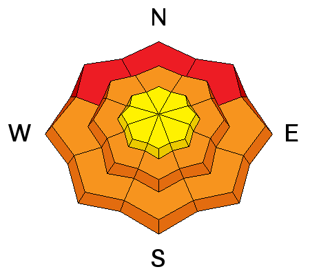
bottom line The avalanche danger will rise significantly today, with warming temperatures, rain up to 8500', heavy snow, and strengthening southwest winds. Rising temperatures and rain-on-snow will cause increasingly dangerous wet avalanche conditions at low and mid elevations. With enough rain, the danger could rise to HIGH, with natural wet avalanches becoming likely by evening. Avoid and stay out from under steep slopes, potential avalanche runouts, and historic avalanche paths.
|
 |
avalanche warning THE FOREST SERVICE UTAH AVALANCHE CENTER IN SALT LAKE CITY HAS ISSUED A BACKCOUNTRY AVALANCHE WARNING. * TIMING...IN EFFECT FROM 1000 PM MST TONIGHT TO 600 PM MST WEDNESDAY. | * AFFECTED AREA...FOR THE MOUNTAINS OF NORTHERN UTAH INCLUDING THE WASATCH RANGE, BEAR RIVER RANGE, SOUTHEAST IDAHO, UINTA MOUNTAINS AND MANTI-SKYLINE PLATEAU. * AVALANCHE DANGER...THE AVALANCHE DANGER FOR THE WARNING AREA WILL RISE TO HIGH TOMORROW AND TOWARD EXTREME BY MONDAY. * REASON/IMPACTS... EXPECTED HEAVY SNOWFALL AND STRONG WINDS, COMBINED WITH RAIN ON SNOW AT THE LOWER ELEVATIONS WILL CREATE WIDESPREAD DANGEROUS AVALANCHE CONDITIONS ON MANY ASPECTS AND ELEVATIONS. NATURAL AND HUMAN TRIGGERED AVALANCHES ARE CERTAIN. THOSE WITHOUT EXCELLENT AVALANCHE SKILLS SHOULD AVOID BEING ON OR UNDERNEATH STEEP SLOPES. EVEN AVALANCHES RELEASING OFF STEEP ROOFS MAY BE DANGEROUS IN THE URBAN AND MOUNTAIN VALLEYS. BACKCOUNTRY TRAVELERS SHOULD CONSULT WWW.UTAHAVALANCHECENTER.ORG OR CALL 1-888-999-4019 FOR MORE DETAILED INFORMATION. THIS WARNING DOES APPLY TO SKI AREAS WHERE AVALANCHE HAZARD REDUCTION MEASURES ARE PERFORMED. |
 |
current conditions The Tony Grove Snotel at 8400' reports 27 degrees F with 5" of new snow and .7" SWE (Snow Water Equivalent). There's 67" of total snow containing 131% of average SWE. It's 21 degrees F at the CSI Logan Peak weather station at 9700', south winds slackened a bit overnight, but are currently 25 mph, gusting to 45 mph. Very cold temperatures for the past couple days kept the powder riding nice, even on south facing and low elevation slopes. Natural avalanches occurred during the midweek storm across the zone including at low elevations in the foothills and farm fields. Climbing temperatures and rain at lower elevations will create serious problems in the next couple days. Officials are warning of significant potential for flooding, and rain-on-snow will lead to a HIGH danger of wet avalanches in low elevation terrain. Wet avalanches at lower elevations may threaten runners, dog walkers, fishermen, and children innocently playing in the snow. One of our biggest concerns with the warmth and possible rain is potential for roof avalanches down in the valley. Watch out for snow and ice falling off buildings and don't let the kids play where snow from the roof could slide down on top of them. |
 |
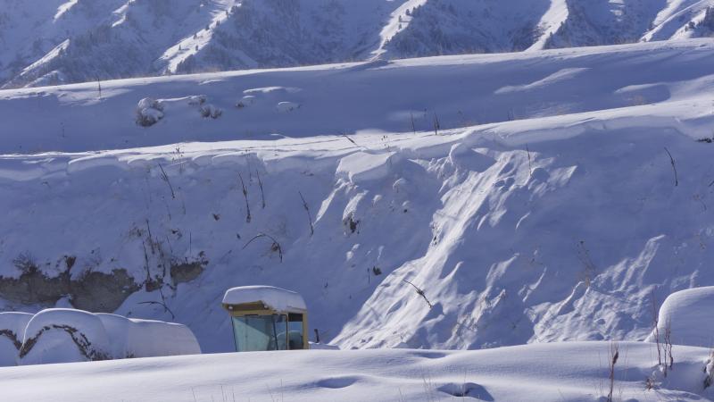
recent activity Natural activity was widespread across the Logan Zone during Wednesday's storm, with avalanches at all elevations and on most slope aspects. The activity included widespread natural avalanches at low elevation, some down in Cache Valley.
These low elevation avalanches near Mendon occurred Wednesday night during the intense storm. |
| type | aspect/elevation | characteristics |
|---|

|
|
LIKELIHOOD
 LIKELY
UNLIKELY
SIZE
 LARGE
SMALL
TREND
 INCREASING DANGER
SAME
DECREASING DANGER
|
|
description
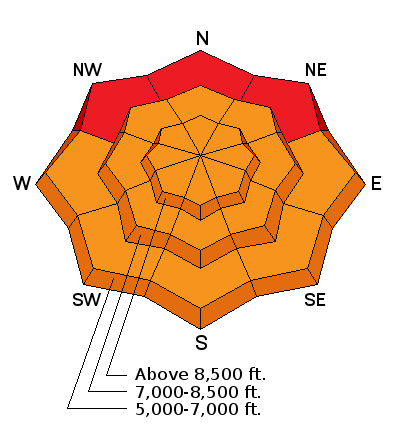
Dangerous wind slab conditions exist this morning on drifted upper and mid elevation slopes, and the danger will increase and become more widespread by evening. Triggered wind slab avalanches are likely today on drifted slopes steeper than 30 degrees.
|
| type | aspect/elevation | characteristics |
|---|

|
|
LIKELIHOOD
LIKELY
UNLIKELY
SIZE
 LARGE
SMALL
TREND
INCREASING DANGER
SAME
DECREASING DANGER
|
|
description
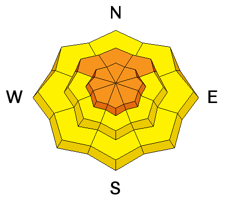
Persistent slab avalanches, failing on buried weak layers, are possible on many slopes and will become more likely with today's loading.
|
| type | aspect/elevation | characteristics |
|---|

|
|
LIKELIHOOD
LIKELY
UNLIKELY
SIZE
LARGE
SMALL
TREND
INCREASING DANGER
SAME
DECREASING DANGER
|
|
description
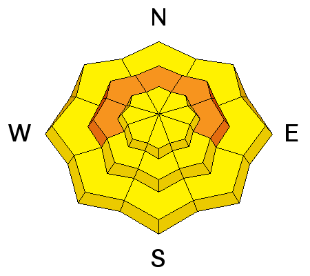
Snow will switch over to rain during the day, and the snow line could rise as high as 8500'. Rain at lower and mid elevations will continue overnight and into tomorrow. Warm rain on cold snow is never a good thing, and it will create very dangerous conditions at lower elevations. Natural wet avalanches will be likely as the low elevation snow becomes saturated. Avoid being under steep slopes with saturated snow in the canyons and foothills, and watch for an increasing danger of roof avalanches. Among many lower elevation areas, wet avalanches could threaten areas like the Logan and Blacksmith Fork rivers, the river trail and highway 89 in Logan Canyon, the Providence Canyon trail, and access to the Green Canyon TH. |
 |
weather An active pattern will develop across the region with several storms expected to bring precipitation to the area through at least Friday. Temperatures will warm significantly early this week as warmer air spreads over the Great Basin. Expect 4 to 8 inches of snow during the day, breezy southwest winds, and a high temperature of 31 degrees at 8500'. Snow will change over to rain up into mid elevations tonight, with a high temperature of 36 expected by around 10:00 PM. 4 to 8 inches of accumulation is expected, with sustained 30 mph southwest winds. Temperatures should drop below freezing at 8000' on Monday afternoon, with strong west wind and 8 to 12 inches of additional heavy snow possible... |
| general announcements The early season is a great time to practice companion rescue techniques with your partners. Companion Rescue Practice Video The National Avalanche Center just released their Avalanche Problems Explained video... Not all avalanches are made the same. As a result, travel and decisions in avalanche terrain are influenced by the kind of avalanche you expect to encounter. Watch HERE Check out Avalanche Canada's "Rescue at Cherry Bowl" story HERE Discount lift tickets for Beaver Mountain, Snowbasin, Powder Mountain, and the Central Wasatch resorts are donated by the resorts to benefit the Utah Avalanche Center. Details and order information here. Between now and Jan 15th: Donate to the Utah Avalanche Center by shopping at Whole Foods Market Utah! When you visit any Utah Whole Foods Market locations, bring your re-usable bags, Whole Foods will donate a dime per bag to the Utah Avalanche Center - if you say DONATE my bag credit. Your information can save lives. If you see anything we should know please help us out by submitting snow and avalanche observations. You can call us at 801-524-5304, email by clicking HERE, or include @utavy in your Instagram. In the Logan Area you can reach me at 435-757-7578 We will update this advisory regularly on Monday, Wednesday, Friday, and Saturday mornings by about 7:30. This advisory is from the U.S.D.A. Forest Service, which is solely responsible for its content. This advisory describes general avalanche conditions and local variations always exist. |