25th Annual Black Diamond Fall Fundraising Party
Thursday, September 13; 6:00-10:00 PM; Black Diamond Parking Lot
25th Annual Black Diamond Fall Fundraising Party
Thursday, September 13; 6:00-10:00 PM; Black Diamond Parking Lot
| Advisory: Logan Area Mountains | Issued by Toby Weed for Thursday - January 5, 2017 - 7:01am |
|---|

|
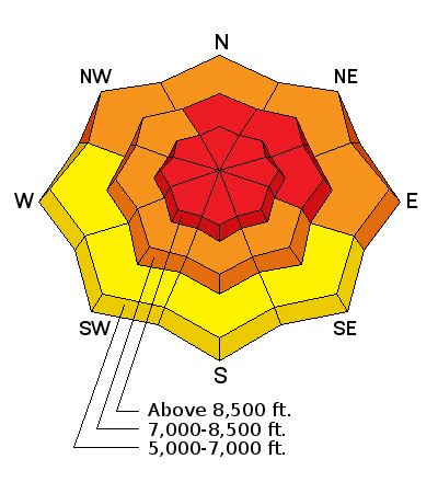
bottom line The avalanche danger is HIGH today in the backcountry. Heavy new snow and strong winds created areas of unstable snow, and very dangerous avalanche conditions exist. Give the snow a little time to adjust to the new load. Avoid travel in avalanche terrain. Stay off and out from under steep slopes, potential avalanche runout zones, and historic avalanche paths.
|
 |
avalanche warning THE FOREST SERVICE UTAH AVALANCHE CENTER IN SALT LAKE CITY HAS CONTINUED A BACKCOUNTRY AVALANCHE WARNING. * TIMING…IN EFFECT FROM 6 AM MST THIS MORNING TO 6 AM MST FRIDAY * AFFECTED AREA…FOR THE MOUNTAINS OF NORTHERN UTAH AND SOUTHEAST IDAHO INCLUDING THE WASATCH RANGE...BEAR RIVER RANGE...AND WESTERN UINTA MOUNTAINS * AVALANCHE DANGER…THE AVALANCHE DANGER FOR THE WARNING AREA IS HIGH TODAY. * IMPACTS…RECENT HEAVY SNOW COMBINED WITH WIND WILL LIKELY CREATE WIDESPREAD AREAS OF UNSTABLE SNOW. BOTH HUMAN TRIGGERED AND NATURAL AVALANCHES ARE LIKELY. STAY OFF OF AND OUT FROM UNDER SLOPES STEEPER THAN 30 DEGREES. BACKCOUNTRY TRAVELERS SHOULD CONSULT WWW.UTAHAVALANCHECENTER.ORG OR CALL 1-888-999-4019 FOR MORE DETAILED INFORMATION. THIS WARNING DOES NOT APPLY TO SKI AREAS WHERE AVALANCHE HAZARD REDUCTION MEASURES ARE PERFORMED. |
 |
special announcement Join us tonight, January 5 and 7 for an avalanche awareness class in Logan. We'll spend this evening in the classroom and Saturday in the field. You'll learn avalanche rescue techniques, safe travel protocol and terrain management. Treat yourself to the gift of knowledge. It may save your life. Register online: HERE |
 |
current conditions The Tony Grove Snotel at 8400' reports 23 inches of settled new snow on the total snow stake in the last 48 hours with 3 inches of Snow Water Equivalent (SWE). It's 4 degrees with 72" of total snow containing 130% of average SWE. It's 1 degree F at the CSI Logan Peak weather station at 9700', west winds diminished overnight and are currently averaging less than 10 mph. Strong wind and heavy snowfall in the past 2 days have created areas with unstable snow, and very dangerous avalanche conditions exist in the backcountry. Avoid travel in avalanche terrain today! |
 |
recent activity Avalanche reduction teams in the Ogden Mountains found sensitive avalanche conditions yesterday and triggered sizable avalanches with slope cuts and explosives. Partial clearing today should allow for some visibility, and I expect to observe and receive reports of natural activity from yesterday and overnight, but no significant avalanches were yet reported in the Logan Zone. |
| type | aspect/elevation | characteristics |
|---|

|
|
LIKELIHOOD
 LIKELY
UNLIKELY
SIZE
 LARGE
SMALL
TREND
 INCREASING DANGER
SAME
DECREASING DANGER
|
|
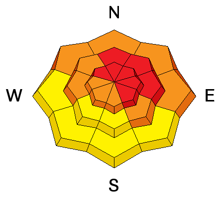
description
Drifting snow created very dangerous wind slab avalanche conditions in exposed terrain. Triggered wind slab avalanches are likely today on drifted slopes at upper and mid elevations.
|
| type | aspect/elevation | characteristics |
|---|

|
|
LIKELIHOOD
LIKELY
UNLIKELY
SIZE
LARGE
SMALL
TREND
INCREASING DANGER
SAME
DECREASING DANGER
|
|
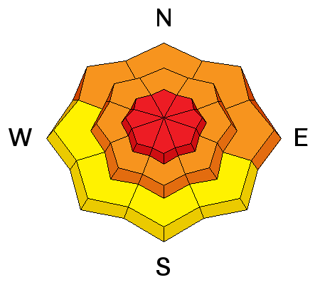
description
Weak surface snow made up of feathery surface hoar and/or small grained near surface facets was widespread across the zone before the New Years snow began. On slopes where this weak snow was preserved by the light snow and not destroyed by warmth or wind, triggered soft slab avalanches including all the fresh snow are likely. Remotely triggered avalanches are possible. |
| type | aspect/elevation | characteristics |
|---|

|
|
LIKELIHOOD
 LIKELY
UNLIKELY
SIZE
 LARGE
SMALL
TREND
 INCREASING DANGER
SAME
DECREASING DANGER
|
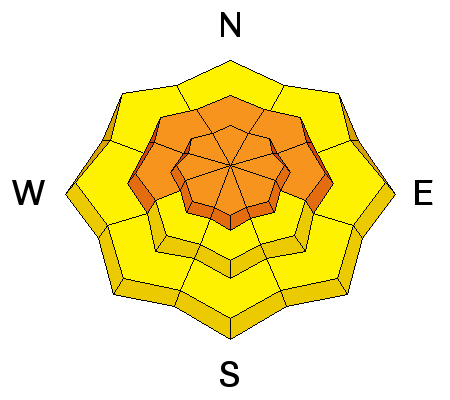
description
|
 |
weather A cold high pressure system will set up over the region for tomorrow and Saturday, before a mild and active weather pattern sets up for next week. Expect partly sunny and cold conditions today, with a high at 8500' of 10 degrees and a moderate north wind pushing wind chill values down to around -18 F. The 7 to 10 mph wind will veer from the east-northeast this afternoon. Temperatures will drop to 1 degree below zero F overnight, with continuing northeast winds. It should be mostly sunny on Friday, with west winds around 10 mph and a high temperature of 12 degrees. |
| general announcements The early season is a great time to practice companion rescue techniques with your partners. Companion Rescue Practice Video The National Avalanche Center just released their Avalanche Problems Explained video... Not all avalanches are made the same. As a result, travel and decisions in avalanche terrain are influenced by the kind of avalanche you expect to encounter. Watch HERE Check out Avalanche Canada's "Rescue at Cherry Bowl" story HERE Discount lift tickets for Beaver Mountain, Snowbasin, Powder Mountain, and the Central Wasatch resorts are donated by the resorts to benefit the Utah Avalanche Center. Details and order information here. Between now and Jan 15th: Donate to the Utah Avalanche Center by shopping at Whole Foods Market Utah! When you visit any Utah Whole Foods Market locations, bring your re-usable bags, Whole Foods will donate a dime per bag to the Utah Avalanche Center - if you say DONATE my bag credit. Your information can save lives. If you see anything we should know please help us out by submitting snow and avalanche observations. You can call us at 801-524-5304, email by clicking HERE, or include @utavy in your Instagram. In the Logan Area you can reach me at 435-757-7578 We will update this advisory regularly on Monday, Wednesday, Friday, and Saturday mornings by about 7:30. This advisory is from the U.S.D.A. Forest Service, which is solely responsible for its content. This advisory describes general avalanche conditions and local variations always exist. |


