25th Annual Black Diamond Fall Fundraising Party
Thursday, September 13; 6:00-10:00 PM; Black Diamond Parking Lot
25th Annual Black Diamond Fall Fundraising Party
Thursday, September 13; 6:00-10:00 PM; Black Diamond Parking Lot
| Advisory: Logan Area Mountains | Issued by Toby Weed for Wednesday - January 4, 2017 - 7:07am |
|---|

|
bottom line Heavy new snow and strong winds are rapidly creating dangerous avalanche conditions, and the danger will rise to HIGH today. Natural avalanches are likely later today and overnight. Avoid travel in avalanche terrain. Stay off and out from under steep slopes, potential avalanche runout zones, and historic avalanche paths.
|
 |
avalanche warning THE FOREST SERVICE UTAH AVALANCHE CENTER IN SALT LAKE CITY HAS ISSUED A BACKCOUNTRY AVALANCHE WARNING. * TIMING...IN EFFECT FROM 1 PM MST THIS AFTERNOON TO 6 AM MST THURSDAY. * AFFECTED AREA...FOR THE MOUNTAINS OF NORTHERN UTAH AND SOUTHEAST IDAHO INCLUDING THE WASATCH RANGE...BEAR RIVER RANGE AND THE WESTERN UINTA MOUNTAINS. * AVALANCHE DANGER...THE AVALANCHE DANGER FOR THE WARNING AREA IS HIGH. A HIGH AVALANCHE DANGER EXISTS IN THE UINTA MOUNTAINS AND THE MOUNTAINS NORTH OF I-80. AS THE STORM PROGRESSES SOUTHWARD...VERY DANGEROUS CONDITIONS AND A HIGH AVALANCHE DANGER WILL ALSO DEVELOP IN THE MOUNTAINS SOUTH OF I-80. * IMPACTS...HEAVY SNOW COMBINED WITH STRONG WINDS ARE CREATING WIDESPREAD AREAS OF UNSTABLE SNOW. BOTH HUMAN TRIGGERED AND NATURAL AVALANCHES ARE LIKELY OR OCCURRING. STAY OFF OF AND OUT FROM UNDER SLOPES STEEPER THAN 30 DEGREES. BACKCOUNTRY TRAVELERS SHOULD CONSULT WWW.UTAHAVALANCHECENTER.ORG OR CALL 1-888-999-4019 FOR MORE DETAILED INFORMATION. THIS WARNING DOES NOT APPLY TO SKI AREAS WHERE AVALANCHE HAZARD REDUCTION MEASURES ARE PERFORMED. |
 |
special announcement Start off the new year by opening your eyes to the world of avalanches! Join us at Cherry Peak Ski Resort on Wednesday, January 4 at 6:30pm for a FREE Know Before You Go avalanche awareness talk. Not much science, no warnings to stay out of the mountains, no formulas to memorize. In 1 hour, you will see the destructive power of avalanches, understand when and why they happen, and how you can have fun in the mountains and avoid avalanches. No matter if you ride a sled or carve a board, this class is for anyone who ventures into the backcountry and wants to learn how to stay safe. Family friendly! Join us January 5 and 7 for an avalanche awareness class in Logan. We'll spend Thursday evening in the classroom and Saturday in the field. You'll learn avalanche rescue techniques, safe travel protocol and terrain management. Treat yourself to the gift of knowledge. It may save your life. |
 |
current conditions The Tony Grove Snotel at 8400' reports 11 inches of new snow in the last 24 hours with an inch of water. It's 23 degrees with 64" of total snow containing 117% of average SWE (snow water equivalent). It's 17 degrees at the CSI Logan Peak weather station at 9700', south-southwest winds are intensifying significantly, gusting to 53 mph. Dangerous conditions exist in the backcountry and the danger will continue to rise today with strengthening wind and continued heavy snowfall. Change your plans! Avoid travel in avalanche terrain today! |
 |
recent activity No significant avalanches were reported in the past couple days. |
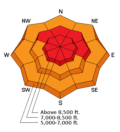
| type | aspect/elevation | characteristics |
|---|

|
|
LIKELIHOOD
 LIKELY
UNLIKELY
SIZE
 LARGE
SMALL
TREND
 INCREASING DANGER
SAME
DECREASING DANGER
|
|
description
Drifting snow has created dangerous wind slab avalanche conditions in exposed terrain, and intensifying wind means the danger will continue to rise and become more widespread. Both triggered and natural wind slab avalanches are likely, and fresh wind slabs will be very easy to trigger. |
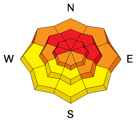
| type | aspect/elevation | characteristics |
|---|

|
|
LIKELIHOOD
LIKELY
UNLIKELY
SIZE
LARGE
SMALL
TREND
INCREASING DANGER
SAME
DECREASING DANGER
|
|
description
Weak surface snow made up of feathery surface hoar and/or small grained near surface facets was widespread across the zone before the New Years snow began. On slopes where this weak snow was preserved by the light snow and not destroyed by warmth or wind, soft slab avalanches including all the fresh snow are likely. Remote triggered avalanches are possible, meaning you could trigger avalanches from a distance or from below. Natural avalanches involving the storm snow are likely on steep slopes later today and tonight. |
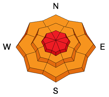
| type | aspect/elevation | characteristics |
|---|

|
|
LIKELIHOOD
 LIKELY
UNLIKELY
SIZE
 LARGE
SMALL
TREND
INCREASING DANGER
SAME
DECREASING DANGER
|
description
|
 |
weather Expect continuing snow today, with an additional 9 to 13 inches possible and a high temperature at 8500' of 21 degrees. West and southwest winds will continue to intensify today averaging near 30 mph, with gusts in the 50s. The winds will diminish but snow will continue tonight, with 5 to 9 additional inches of accumulation possible and west winds becoming south after midnight. The stormy weather should clear out of the zone on Thursday, and a short-lived high pressure system will set up over the region Friday into early Saturday. The next storm will arrive Saturday night and last through Sunday and Monday... |
| general announcements The early season is a great time to practice companion rescue techniques with your partners. Companion Rescue Practice Video The National Avalanche Center just released their Avalanche Problems Explained video... Not all avalanches are made the same. As a result, travel and decisions in avalanche terrain are influenced by the kind of avalanche you expect to encounter. Watch HERE Check out Avalanche Canada's "Rescue at Cherry Bowl" story HERE Discount lift tickets for Beaver Mountain, Snowbasin, Powder Mountain, and the Central Wasatch resorts are donated by the resorts to benefit the Utah Avalanche Center. Details and order information here. Between now and Jan 15th: Donate to the Utah Avalanche Center by shopping at Whole Foods Market Utah! When you visit any Utah Whole Foods Market locations, bring your re-usable bags, Whole Foods will donate a dime per bag to the Utah Avalanche Center - if you say DONATE my bag credit. Your information can save lives. If you see anything we should know please help us out by submitting snow and avalanche observations. You can call us at 801-524-5304, email by clicking HERE, or include @utavy in your Instagram. In the Logan Area you can reach me at 435-757-7578 We will update this advisory regularly on Monday, Wednesday, Friday, and Saturday mornings by about 7:30. This advisory is from the U.S.D.A. Forest Service, which is solely responsible for its content. This advisory describes general avalanche conditions and local variations always exist. |


