25th Annual Black Diamond Fall Fundraising Party
Thursday, September 13; 6:00-10:00 PM; Black Diamond Parking Lot
25th Annual Black Diamond Fall Fundraising Party
Thursday, September 13; 6:00-10:00 PM; Black Diamond Parking Lot
| Advisory: Logan Area Mountains | Issued by Toby Weed for Monday - January 2, 2017 - 6:56am |
|---|


|
bottom line Heightened wind slab and storm snow avalanche conditions exist in the backcountry. Sensitive human triggered avalanches involving the new snow are likely on drifted slopes and in areas where weak surface snow was buried intact. Evaluate snow and terrain carefully.
|
 |
special announcement Start off the new year by opening your eyes to the world of avalanches! Join us at Cherry Peak Ski Resort on Wednesday, January 4 at 6:30pm for a FREE Know Before You Go avalanche awareness talk. Not much science, no warnings to stay out of the mountains, no formulas to memorize. In 1 hour, you will see the destructive power of avalanches, understand when and why they happen, and how you can have fun in the mountains and avoid avalanches. No matter if you ride a sled or carve a board, this class is for anyone who ventures into the backcountry and wants to learn how to stay safe. Family friendly! Join us January 5 and 7 for an avalanche awareness class in Logan. We'll spend Thursday evening in the classroom and Saturday in the field. You'll learn avalanche rescue techniques, safe travel protocol and terrain management. Treat yourself to the gift of knowledge. It may save your life. |
 |
current conditions The local automated Snotel sites haven't updated with overnight snow amounts, but Beaver Mountain reports 7" of new snow overnight, Powder Mountain 8", Snowbasin 8", and a similar amount on the floor of Cache Valley. It's 5 degrees at the CSI Logan Peak weather station at 9700', and there is a 14 mph southwest wind. Drifting snow was an issue at upper elevations last night, with light snow and moderate but sustained southwest and west winds. In more sheltered and mid-elevation terrain, the nice new 2017 snow fell without much wind on weak surface snow, preserving it. We should find nice winter powder riding conditions in the backcountry today, but fresh wind slab and shallow storm slab avalanches may be quite sensitive to human triggering, and remote triggered avalanches are possible.
Feathery surface hoar on the snow surface in Providence Canyon this weekend. (Staples 12/31/16) |
 |
recent activity Reported avalanche activity in the Logan Zone:
|
| type | aspect/elevation | characteristics |
|---|

|
|
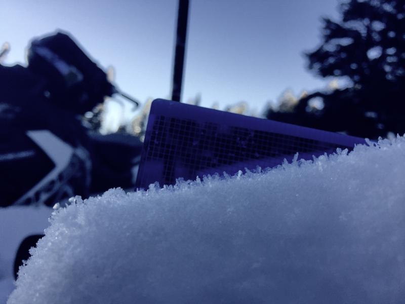
LIKELIHOOD
 LIKELY
UNLIKELY
SIZE
 LARGE
SMALL
TREND
 INCREASING DANGER
SAME
DECREASING DANGER
|
|
description
Drifting snow has created heightened wind slab avalanche conditions in exposed terrain. Fresh wind slabs will be soft and very easy to trigger today.
|
| type | aspect/elevation | characteristics |
|---|

|
|
LIKELIHOOD
LIKELY
UNLIKELY
SIZE
LARGE
SMALL
TREND
 INCREASING DANGER
SAME
DECREASING DANGER
|
|
description
Weak surface snow made up of feathery surface hoar and/or small grained near surface facets was widespread across the zone before the snow started falling yesterday evening. On slopes where this weak snow was not destroyed by warmth or wind, soft slab avalanches including all the fresh snow may occur. Remote triggered avalanches are possible, meaning you could trigger avalanches from a distance or from below. Loose dry avalanches or sluffs involving the new snow are likely, and the debris could pile up deeply in terrain traps below steep slopes... |
 |
weather Expect continuing snow today, with an additional 2 to 4 inches possible and a high temperature at 8500' of 13 degrees. West and southwest winds will continue, but should mostly remain below 25 mph on the ridges. Snow and cold temperatures will continue through the week, with a warm front Tuesday night and Wednesday bringing the next significant shot to the Logan Zone, with a foot or so of new snow possible. |
| general announcements The early season is a great time to practice companion rescue techniques with your partners. Companion Rescue Practice Video The National Avalanche Center just released their Avalanche Problems Explained video... Not all avalanches are made the same. As a result, travel and decisions in avalanche terrain are influenced by the kind of avalanche you expect to encounter. Watch HERE Check out Avalanche Canada's "Rescue at Cherry Bowl" story HERE Discount lift tickets for Beaver Mountain, Snowbasin, Powder Mountain, and the Central Wasatch resorts are donated by the resorts to benefit the Utah Avalanche Center. Details and order information here. Between now and Jan 15th: Donate to the Utah Avalanche Center by shopping at Whole Foods Market Utah! When you visit any Utah Whole Foods Market locations, bring your re-usable bags, Whole Foods will donate a dime per bag to the Utah Avalanche Center - if you say DONATE my bag credit. Your information can save lives. If you see anything we should know please help us out by submitting snow and avalanche observations. You can call us at 801-524-5304, email by clicking HERE, or include @utavy in your Instagram. In the Logan Area you can reach me at 435-757-7578 We will update this advisory regularly on Monday, Wednesday, Friday, and Saturday mornings by about 7:30. This advisory is from the U.S.D.A. Forest Service, which is solely responsible for its content. This advisory describes general avalanche conditions and local variations always exist. |