25th Annual Black Diamond Fall Fundraising Party
Thursday, September 13; 6:00-10:00 PM; Black Diamond Parking Lot
25th Annual Black Diamond Fall Fundraising Party
Thursday, September 13; 6:00-10:00 PM; Black Diamond Parking Lot
| Advisory: Logan Area Mountains | Issued by Toby Weed for Saturday - December 31, 2016 - 6:09am |
|---|

|
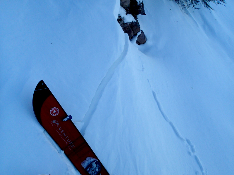
bottom line The snow is stable and avalanches are unlikely on many slopes, but heightened wind slab avalanche conditions exist on drifted slopes at upper elevations. Also, triggered persistent slab avalanches are still possible on slopes with buried weak layers. Evaluate snow and terrain carefully.
|
 |
special announcement Join us January 5 and 7 for an avalanche awareness class in Logan. We'll spend Thursday evening in the classroom and Saturday in the field. You'll learn avalanche rescue techniques, safe travel protocol and terrain management. Treat yourself to the gift of knowledge. It may save your life. Register online: https://utahavalanchecenter.org/classes/avalanche-awareness-class-logan-0 The National Avalanche Center just released their Avalanche Problems Explained video... Not all avalanches are made the same. As a result, travel and decisions in avalanche terrain are influenced by the kind of avalanche you expect to encounter. Watch HERE |
 |
current conditions The Tony Grove Snotel at 8400' reports 15 degrees and 50" of total snow containing 111% of average SWE for the date. It's 12 degrees at the CSI Logan Peak weather station at 9700', and there is a 20 mph west wind. There's still nice re-crystallized powder in sheltered areas, but wind and warmth have created a wide variety of snow conditions. |
 |
recent activity Reported avalanche activity in the Logan Zone:
|
| type | aspect/elevation | characteristics |
|---|

|
|
LIKELIHOOD
 LIKELY
UNLIKELY
SIZE
 LARGE
SMALL
TREND
 INCREASING DANGER
SAME
DECREASING DANGER
|
|
description
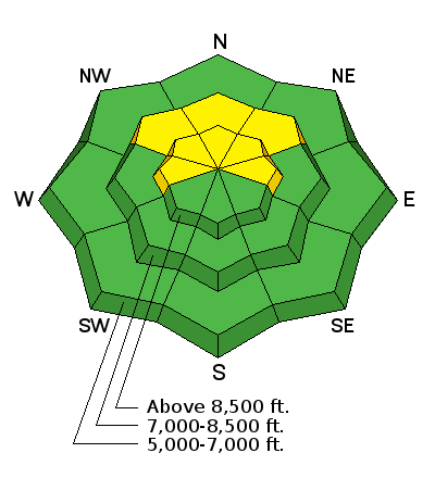
Drifting snow has created heightened wind slab avalanche conditions in exposed terrain. Slabs up to 2' deep formed on last week's weak snow. These will be stubborn and hard to trigger today. Hard wind slabs may allow you to get out on them before releasing and sometimes break above you.
|
| type | aspect/elevation | characteristics |
|---|

|
|
LIKELIHOOD
 LIKELY
UNLIKELY
SIZE
 LARGE
SMALL
TREND
INCREASING DANGER
SAME
DECREASING DANGER
|
|
description
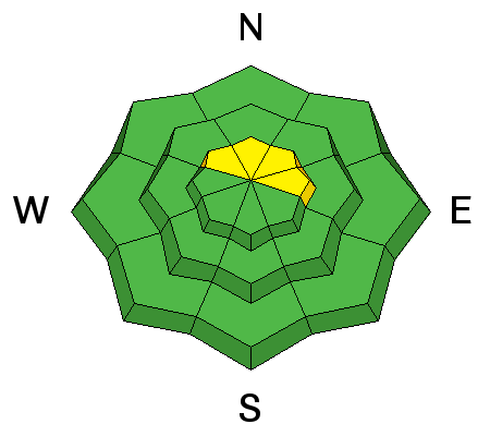
Buried weak surface snow made up of surface hoar and/or near surface facets can still be found in pockets across the zone, and triggered persistent slabs around a foot deep are possible.
|
 |
weather A high pressure system controls the weather pattern and the inversion will remain in place through the weekend. A stronger, much colder system will affect the Great Basin for much of next week. Atmospheric mixing will begin on New Years Day, with increasing west wind and 1 or 2 inches of snow possible. Snow is likely Sunday night continuing into Monday, with 4 to 7 inches possible. An arctic weather pattern of single digit and sub-zero temperatures and unsettled weather will set up through the first week of 2017. |
| general announcements The early season is a great time to practice companion rescue techniques with your partners. Companion Rescue Practice Video Discount lift tickets for Beaver Mountain, Snowbasin, Powder Mountain, and the Central Wasatch resorts are donated by the resorts to benefit the Utah Avalanche Center. Details and order information here. Check out Avalanche Canada's "Rescue at Cherry Bowl" story HERE Between now and Jan 15th: Donate to the Utah Avalanche Center by shopping at Whole Foods Market Utah! When you visit any Utah Whole Foods Market locations, bring your re-usable bags, Whole Foods will donate a dime per bag to the Utah Avalanche Center - if you say DONATE my bag credit. We will update this advisory regularly on Monday, Wednesday, Friday, and Saturday mornings by about 7:30. Your information can save lives. If you see anything we should know please help us out by submitting snow and avalanche observations. You can call us at 801-524-5304, email by clicking HERE, or include @utavy in your Instagram. In the Logan Area you can reach me at 435-757-7578 This advisory is from the U.S.D.A. Forest Service, which is solely responsible for its content. This advisory describes general avalanche conditions and local variations always exist. |