25th Annual Black Diamond Fall Fundraising Party
Thursday, September 13; 6:00-10:00 PM; Black Diamond Parking Lot
25th Annual Black Diamond Fall Fundraising Party
Thursday, September 13; 6:00-10:00 PM; Black Diamond Parking Lot
| Advisory: Logan Area Mountains | Issued by Toby Weed for Wednesday - December 28, 2016 - 7:12am |
|---|

|
bottom line Dangerous avalanche conditions exist on drifted slopes at upper and mid elevations. Triggered persistent slab avalanches are possible on slopes steeper than 30 degrees with buried weak layers. Nice powder conditions and mostly stable snow can be found in lower angled, lower elevation, and sheltered terrain. Careful snowpack evaluation, cautious route-finding and conservative decision making are essential.
|
 |
special announcement Join us January 5 and 7 for an avalanche awareness class in Logan. We'll spend Thursday evening in the classroom and Saturday in the field. You'll learn avalanche rescue techniques, safe travel protocol and terrain management. Treat yourself to the gift of knowledge. It may save your life. Register online: https://utahavalanchecenter.org/classes/avalanche-awareness-class-logan-0 |
 |
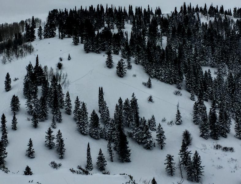
current conditions The Tony Grove Snotel at 8400' reports 18 degrees and 2" of new snow overnight. There's now 52" of total snow containing 114% of average SWE for the date. It's 10 degrees at the CSI Logan Peak weather station at 9700', and there is a 15 mph west wind. Breezy conditions will continue today, but the winds have calmed a little compared to yesterday's plume-driving roar. Drifting snow has created dangerous avalanche conditions at upper and mid elevations in exposed terrain, but fine powder riding conditions exist on lower angled slopes and in sheltered areas. South facing slopes at mid and lower elevations have developed a thin sun-crust. |
 |
recent activity
12-27-16, Skier triggered avalanche above Paradise Reported avalanche activity in the Logan Zone:
|
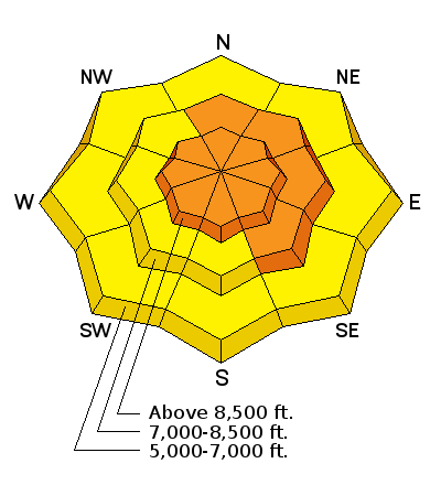
| type | aspect/elevation | characteristics |
|---|

|
|
LIKELIHOOD
 LIKELY
UNLIKELY
SIZE
 LARGE
SMALL
TREND
 INCREASING DANGER
SAME
DECREASING DANGER
|
|
description
Drifting snow has created dangerous wind slab avalanche conditions in exposed terrain. Slabs up to 2' deep formed on last week's weak snow and will be sensitive to human triggering.
|
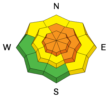
| type | aspect/elevation | characteristics |
|---|

|
|
LIKELIHOOD
 LIKELY
UNLIKELY
SIZE
 LARGE
SMALL
TREND
 INCREASING DANGER
SAME
DECREASING DANGER
|
|
description
Some areas have buried weak surface snow made up of surface hoar and/or near surface facets.
|
 |
weather Snow will diminish today (about 1 inch possible), with partial sun this afternoon and 8500' high temperatures in the mid-teens. 20 to 25 mph west winds will continue throughout the day. A high pressure system will build into the area and last through the remainder of the week, allowing the inversion to set up. Hopefully, storminess will push it out early next week. |
| general announcements The early season is a great time to practice companion rescue techniques with your partners. Companion Rescue Practice Video Discount lift tickets for Beaver Mountain, Snowbasin, Powder Mountain, and the Central Wasatch resorts are donated by the resorts to benefit the Utah Avalanche Center. Details and order information here. Check out Avalanche Canada's "Rescue at Cherry Bowl" story HERE Between now and Jan 15th: Donate to the Utah Avalanche Center by shopping at Whole Foods Market Utah! When you visit any Utah Whole Foods Market locations, bring your re-usable bags, Whole Foods will donate a dime per bag to the Utah Avalanche Center - if you say DONATE my bag credit. We will update this advisory regularly on Monday, Wednesday, Friday, and Saturday mornings by about 7:30. Your information can save lives. If you see anything we should know please help us out by submitting snow and avalanche observations. You can call us at 801-524-5304, email by clicking HERE, or include @utavy in your Instagram. In the Logan Area you can reach me at 435-757-7578 This advisory is from the U.S.D.A. Forest Service, which is solely responsible for its content. This advisory describes general avalanche conditions and local variations always exist. |