25th Annual Black Diamond Fall Fundraising Party
Thursday, September 13; 6:00-10:00 PM; Black Diamond Parking Lot
25th Annual Black Diamond Fall Fundraising Party
Thursday, September 13; 6:00-10:00 PM; Black Diamond Parking Lot
| Advisory: Logan Area Mountains | Issued by Toby Weed for Monday - December 26, 2016 - 7:00am |
|---|

|
bottom line Dangerous avalanche conditions exist in drifted terrain at upper elevations in the backcountry. Triggered avalanches are possible at all elevations, especially on slopes that picked up more than a foot of new snow from the Christmas Storm. Careful snowpack evaluation, cautious route-finding and conservative decision making are essential for safe travel.
|
 |
special announcement Discount lift tickets for Beaver Mountain, Snowbasin, Powder Mountain, and the Central Wasatch resorts are now available, donated by the resorts to benefit the Utah Avalanche Center. Details and order information here. These make a great holiday gift and all proceeds go towards paying for avalanche forecasting and education! |
 |
current conditions The Tony Grove Snotel at 8400' reports 8 degrees this morning and 4" of new snow in the last 24 hrs, bringing the Christmas storm total to around a foot, with 1.1" of water. There's 54" of total snow containing 116% of average water content for the date. Significantly more new snow fell in Cache Valley, the Front Canyons, and the Wellsville Range than in the central Logan Canyon area. It's zero degrees at the CSI Logan Peak weather station at 9700', with a 11 mph west-southwest breeze. Should be a classic powder day, with plenty of nice new Christmas snow, but dangerous avalanche conditions exist on some steep upper elevation slopes. |
 |
recent activity No significant avalanches have been reported in the Logan Area since the 12/15 natural cycle... |
| type | aspect/elevation | characteristics |
|---|

|
|
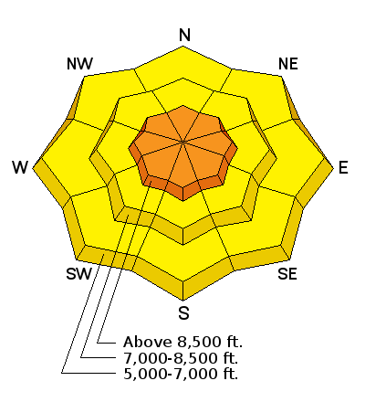
LIKELIHOOD
 LIKELY
UNLIKELY
SIZE
 LARGE
SMALL
TREND
 INCREASING DANGER
SAME
DECREASING DANGER
|
|
description
Heightened storm slab conditions exist on slopes where new snow stacked up on or was drifted onto last week's weak surface snow. Loose dry sluffs are possible in steep terrain and some could pick up momentum running on a slick rain-crust. |
| type | aspect/elevation | characteristics |
|---|

|
|
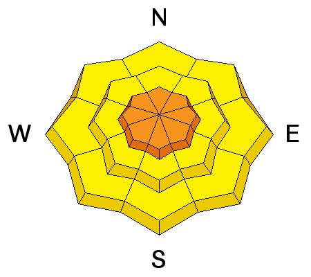
LIKELIHOOD
LIKELY
UNLIKELY
SIZE
LARGE
SMALL
TREND
 INCREASING DANGER
SAME
DECREASING DANGER
|
|
description
Drifting from sustained and uncommon east-southeast winds Friday night and Saturday formed sensitive wind slabs in unexpected places. The drifts are now hidden by several inches of new snow. Moderate westerly winds yesterday and overnight were enough to drift the new powder and create fresh wind slabs in exposed terrain.
|
| type | aspect/elevation | characteristics |
|---|

|
|
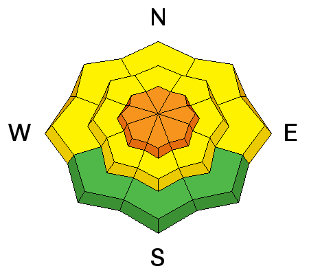
LIKELIHOOD
 LIKELY
UNLIKELY
SIZE
 LARGE
SMALL
TREND
INCREASING DANGER
SAME
DECREASING DANGER
|
description
|
 |
weather Cloudy conditions will mostly clear out by afternoon, but it'll be cold in the mountains with high temperatures at 8500' around 10 degrees and a westerly breeze. It'll be partly cloudy tonight with a slight increase in west winds and wind chills well below zero. The next wave of Pacific storminess will impact the area beginning Tuesday, will a few inches of snow and breezy conditions expected Tuesday night and Wednesday. |
| general announcements The early season is a great time to practice companion rescue techniques with your partners. Companion Rescue Practice Video Check out Avalanche Canada's "Rescue at Cherry Bowl" story HERE Between now and Jan 15th: Donate to the Utah Avalanche Center by shopping at Whole Foods Market Utah! When you visit any Utah Whole Foods Market locations, bring your re-usable bags, Whole Foods will donate a dime per bag to the Utah Avalanche Center - if you say DONATE my bag credit. We will update this advisory regularly on Monday, Wednesday, Friday, and Saturday mornings by about 7:30... Remember your information can save lives. If you see anything we should know please help us out by submitting snow and avalanche observations. You can also call us at 801-524-5304, email by clicking HERE, or include @utavy in your Instagram. In the Logan Area you can get ahold of me at 435-757-7578 This advisory is from the U.S.D.A. Forest Service, which is solely responsible for its content. This advisory describes general avalanche conditions and local variations always exist. |


