25th Annual Black Diamond Fall Fundraising Party
Thursday, September 13; 6:00-10:00 PM; Black Diamond Parking Lot
25th Annual Black Diamond Fall Fundraising Party
Thursday, September 13; 6:00-10:00 PM; Black Diamond Parking Lot
| Advisory: Logan Area Mountains | Issued by Toby Weed for Friday - December 16, 2016 - 6:46am |
|---|

|
bottom line Drifting from strong and sustained south winds, heavy snow accumulation overnight, areas with preexisting weak snow, and rain at lower elevations have created complex and very dangerous avalanche conditions in the backcountry. Avoid and stay out from under steep slopes (>30 degrees) and obvious or historic avalanche paths.
|
 |
avalanche warning THE FOREST SERVICE UTAH AVALANCHE CENTER IN SALT LAKE CITY HAS ISSUED A BACKCOUNTRY AVALANCHE WARNING. * TIMING…IN EFFECT FROM 6 AM MST THIS MORNING TO 6 AM SATURDAY MORNING * AFFECTED AREA…FOR THE MOUNTAINS OF NORTHERN AND CENTRAL UTAH AND SOUTHEAST IDAHO INCLUDING THE WASATCH RANGE...BEAR RIVER RANGE...WESTERN UINTA...AND MANTI SKYLINE MOUNTAINS. * AVALANCHE DANGER…THE AVALANCHE DANGER FOR THE WARNING AREA IS HIGH AND WILL REMAIN HIGH THROUGH SATURDAY. * IMPACTS…HEAVY SNOW, MOUNTAIN RAIN AND STRONG WINDS HAVE CREATED WIDESPREAD AREAS OF UNSTABLE SNOW AT LOW, MID AND UPPER ELEVATIONS. BOTH HUMAN TRIGGERED AND NATURAL AVALANCHES ARE VERY LIKELY. STAY OFF OF AND OUT FROM UNDER SLOPES STEEPER THAN 30 DEGREES AND AVOID AVALANCHE RUNOUT ZONES. BACKCOUNTRY TRAVELERS SHOULD CONSULT WWW.UTAHAVALANCHECENTER.ORG OR CALL 1-888-999-4019 FOR MORE DETAILED INFORMATION. THIS WARNING DOES NOT APPLY TO SKI AREAS WHERE AVALANCHE HAZARD REDUCTION MEASURES ARE PERFORMED. |
 |
special announcement ***Discount lift tickets for Beaver Mountain, Snowbasin, Powder Mountain, and the Central Wasatch resorts are now available, donated by the resorts to benefit the Utah Avalanche Center. Details and order information here. These make a great holiday gift and all proceeds go towards paying for avalanche forecasting and education! |
 |
current conditions The Tony Grove Snotel at 8400' reports 32 degrees with several inches of new snow overnight and 1.2" of snow water equivelent. The site now reports 100% of average water content for the date. The Franklin Basin ID Snotel to the north and the Doc Daniel Snotel to the south report about 13" of new snow from overnight. The CSI Logan Peak weather station at 9700' reports 27 degrees and a 25 mph south wind with gusts near 50 mph early this morning. Beaver Mountain opened yesterday with great snow cover, and offers a safe powder option on a day with HIGH danger in the backcountry. Remember though, that you are entering the backcountry when you leave the ski area boundaries... |
 |
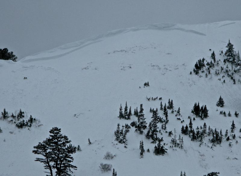
recent activity We noticed a few good sized fresh natural wind slab avalanches and widespread shallow soft slabs yesterday in upper Providence Canyon...
A fresh wind slab avalanche on Providence Peak and a coyote triggered shallow soft slab on both sides of a small gully in the forest. 12-15-16 We've received a couple reports of audible collapsing in the local backcountry, with an extremely large and loud whumpf reported from the Top of Garden City Bowls on Monday morning. Whumpfs are audible collapses of the snowpack, indicating areas of unstable snow. |
| type | aspect/elevation | characteristics |
|---|

|
|
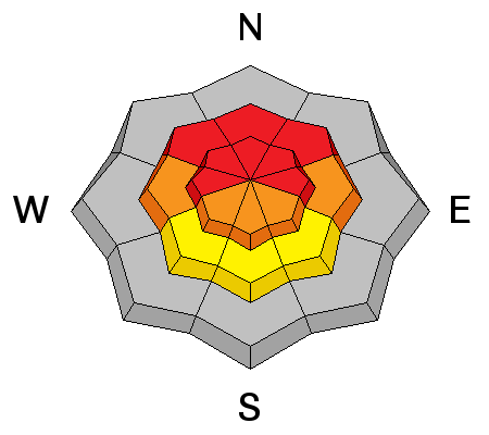
LIKELIHOOD
 LIKELY
UNLIKELY
SIZE
 LARGE
SMALL
TREND
 INCREASING DANGER
SAME
DECREASING DANGER
|
description
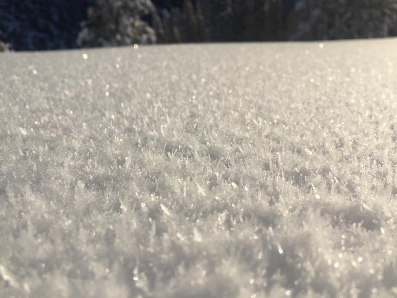
On some slopes, feathery frost crystals on the snow surface called surface hoar were likely buried and preserved by a few inches of snow Wednesday. This will likely be the weak layer for some of today's storm and wind slab avalanches. (Davis, 12-12-16) |
| type | aspect/elevation | characteristics |
|---|

|
|
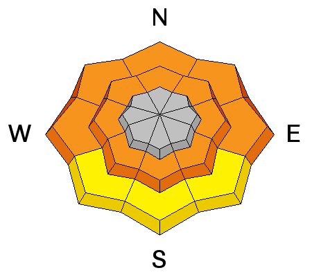
LIKELIHOOD
LIKELY
UNLIKELY
SIZE
 LARGE
SMALL
TREND
INCREASING DANGER
SAME
DECREASING DANGER
|
|
description
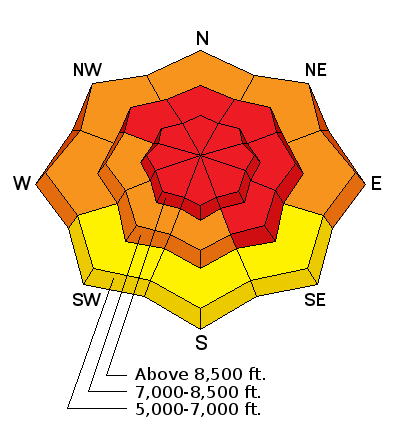
Triggered and natural persistent slab avalanches are likely on some steep slopes at upper and mid elevations. The prolonged storm last weekend overloaded preexisting faceted snow, weakened rapidly last week by a large temperature gradient due to the very cold temperatures in the mountains. A strengthening persistent mid-pack weakness made up of small grained near surface facets is still apparent in test pits, and avalanche reduction teams in the Ogden Area Mountains produced several avalanches failing in old snow yesterday. ***Dangerous and destructive deep slab avalanches, failing on weak faceted snow or depth hoar near the ground are likely today, especially on upper elevation north facing slopes. Drifting yesterday and overnight, and the load from last night's heavy snow, created very dangerous deep slab conditions on slopes with existing poor snow structure. |
| type | aspect/elevation | characteristics |
|---|

|
|
LIKELIHOOD
 LIKELY
UNLIKELY
SIZE
LARGE
SMALL
TREND
 INCREASING DANGER
SAME
DECREASING DANGER
|
|
description
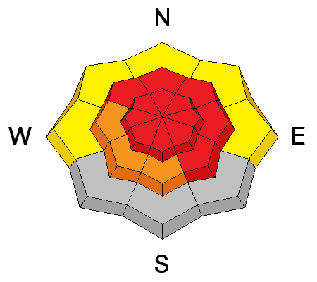
Warm temperatures and rain at lower and mid elevations created an elevated danger of wet avalanches this morning. Best avoid to stay out from under steep slopes with sloppy saturated snow. Cooling later today should help harden the saturated snow lowering the danger |
 |
weather The National Weather Service has continued a Winter Storm Warning for all the mountains of Northern Utah and Southeast Idaho A windy and wet Pacific storm and associated cold front will cross the region today into Saturday. Thereafter an unseasonably cold airmass will remain entrenched across the region into early next week. |
| general announcements The early season is a great time to refresh yourself and practice companion rescue techniques with your partners. Companion Rescue Practice Video Check out Avalanche Canada's "Rescue at Cherry Bowl" story HERE Between now and Jan 15th: Donate to the Utah Avalanche Center by shopping at Whole Foods Market Utah! When you visit any Utah Whole Foods Market locations, bring your re-usable bags, Whole Foods will donate a dime per bag to the Utah Avalanche Center - if you say DONATE my bag credit. Remember your information can save lives. If you see anything we should know about, please help us out by submitting snow and avalanche observations. You can also call us at 801-524-5304, email by clicking HERE, or include @utavy in your Instagram. In the Logan Area you can get ahold of your local avalanche forcaster, me (Toby Weed), at 435-757-7578 This advisory is from the U.S.D.A. Forest Service, which is solely responsible for its content. This advisory describes general avalanche conditions and local variations always exist. |