25th Annual Black Diamond Fall Fundraising Party
Thursday, September 13; 6:00-10:00 PM; Black Diamond Parking Lot
25th Annual Black Diamond Fall Fundraising Party
Thursday, September 13; 6:00-10:00 PM; Black Diamond Parking Lot
| Advisory: Logan Area Mountains | Issued by Toby Weed for Wednesday - December 14, 2016 - 6:15am |
|---|

|
bottom line Heightened avalanche conditions exist in the backcountry, and triggered avalanches are possible on steep upper and mid-elevation slopes.
|
 |
special announcement ***Discount lift tickets for Beaver Mountain, Snowbasin, Powder Mountain, and the Central Wasatch resorts are now available, donated by the resorts to benefit the Utah Avalanche Center. Details and order information here. These make a great holiday gift and all proceeds go towards paying for avalanche forecasting and education! |
 |
current conditions Natural avalanche activity occurred at upper and mid elevations over the weekend. Lower elevations recieved rain, and now sport a couple inches of nice soft (and weak) snow on top of a supportable rain crust. Much colder temperatures may be helping to lock things up, and the snow continues to stabalize as it adjusts to the load from the weekend. Heightened deep and persistent slab avalanche conditions still exist, mainly at upper elevations, and triggered avalanches remain possible. There's now 3 to 4 feet of total snow above about 8000', with more on some slopes. The Tony Grove Snotel at 8400' reports 87% of average water content for the date and 19 degrees this morning. The CSI Logan Peak weather station reports 13 degrees and a 10 mph west wind with gusts near 30 mph early this morning. Beaver Mountain welcomes up-hill hiking traffic this time of year as it helps to pack out the slopes, but you should consider it as "backcountry terrain" before they open the lifts to the public tomorrow! |
 |
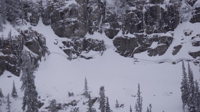
recent activity There was a fairly widespread natural avalanche cycle across the zone on Saturday, during the height of the storm. Most of the evidence of this activity was blown in, covered up, and well hidden by the continuing storm Saturday night and Sunday. No triggered avalanches were reported locally.
Most evidence of the weekend natural cycle is blown in and covered up by snowfall that continued subsequently, but not this sizable crown on a steep north facing slope west of Tony Grove Lake. We've received a couple reports of audible collapsing in the local backcountry, with an extremely large and loud whumpf reported from the Top of Garden City Bowls on Monday morning. Whumpfs are audible collapses of the snowpack, indicating areas of unstable snow. |
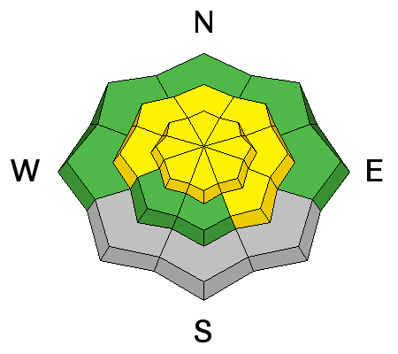
| type | aspect/elevation | characteristics |
|---|

|
|
LIKELIHOOD
 LIKELY
UNLIKELY
SIZE
 LARGE
SMALL
TREND
 INCREASING DANGER
SAME
DECREASING DANGER
|
|
description
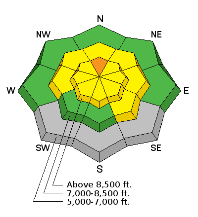
***Dangerous and destructive deep slab avalanches, failing on weak faceted snow or depth hoar near the ground are possible on upper elevation north facing slopes. ***Here' a video look at the pre-storm snow, 12-8-16, Corner Pocket |
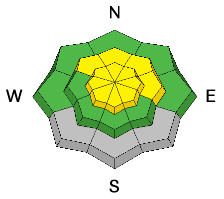
| type | aspect/elevation | characteristics |
|---|

|
|
LIKELIHOOD
LIKELY
UNLIKELY
SIZE
 LARGE
SMALL
TREND
 INCREASING DANGER
SAME
DECREASING DANGER
|
|
description
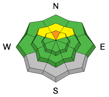
Triggered persistent slab avalanches are still possible on some steep slopes at upper and mid elevations. The prolonged storm last weekend overloaded preexisting faceted snow, weakened rapidly last week by a large temperature gradient due to the very cold temperatures in the mountains. A strengthening persistent mid-pack weakness made up of small grained near surface facets was apparent in test pits...like this from Beaver Mt. Backside on Sunday. |
| type | aspect/elevation | characteristics |
|---|

|
|
LIKELIHOOD
LIKELY
UNLIKELY
SIZE
LARGE
SMALL
TREND
 INCREASING DANGER
SAME
DECREASING DANGER
|
|
description
With a few inches of new snow and increasing southwest winds expected, heightened wind slab avalanche conditions may develop by this afternoon on some drifted slopes. Drifts may build on weak snow currently on the snow surface. It's always a good idea to avoid stiffer recently drifted snow on steep slopes. Drifts may appear rounded and chalky and they may produce hollow, drum-like sounds. Watch for deposits of drifted snow in and around terrain features like gullies, scoops, sub-ridges, and cliff-bands.
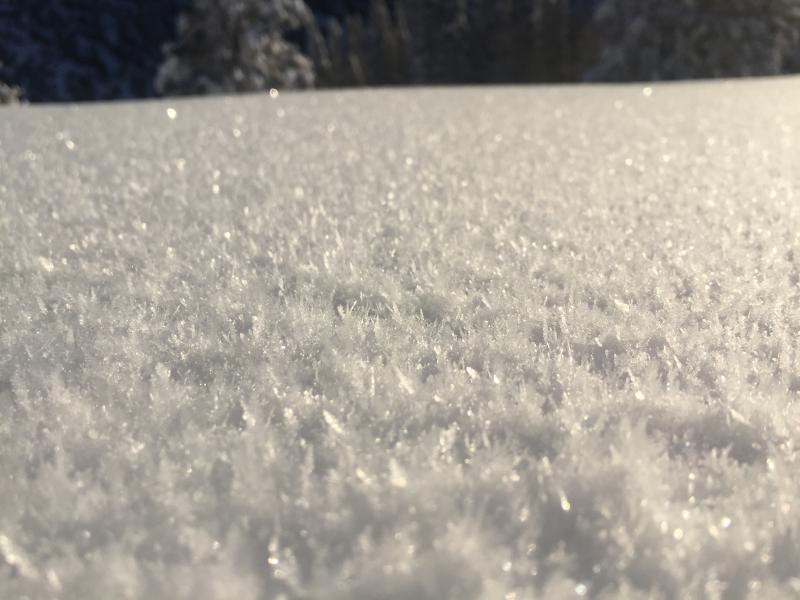
Some slopes sport pretty feathery frost crystals on the snow surface called surface hoar. This has a nasty habit of becoming a tricky persistent weak layer if it's buried intact...(Davis, 12-12-16) |
 |
weather The National Weather Service in Pocatello has issued a Winter Storm Warning for the mountains north of the Idaho State Line... A warm front will lift north across the region today, ushering a mild and increasingly moist airmass northward into the area. A windy and wet Pacific trough and associated cold front will cross the region Friday through Saturday. |
| general announcements The early season is a great time to refresh yourself and practice companion rescue techniques with your partners. Companion Rescue Practice Video Check out Avalanche Canada's "Rescue at Cherry Bowl" story HERE Between now and Jan 15th: Donate to the Utah Avalanche Center by shopping at Whole Foods Market Utah! When you visit any Utah Whole Foods Market locations, bring your re-usable bags, Whole Foods will donate a dime per bag to the Utah Avalanche Center - if you say DONATE my bag credit. Remember your information can save lives. If you see anything we should know about, please help us out by submitting snow and avalanche observations. You can also call us at 801-524-5304, email by clicking HERE, or include @utavy in your Instagram. In the Logan Area you can get ahold of your local avalanche forcaster, me (Toby Weed), at 435-757-7578 This advisory is from the U.S.D.A. Forest Service, which is solely responsible for its content. This advisory describes general avalanche conditions and local variations always exist. |