25th Annual Black Diamond Fall Fundraising Party
Thursday, September 13; 6:00-10:00 PM; Black Diamond Parking Lot
25th Annual Black Diamond Fall Fundraising Party
Thursday, September 13; 6:00-10:00 PM; Black Diamond Parking Lot
| Advisory: Logan Area Mountains | Issued by Toby Weed for Monday - December 12, 2016 - 6:44am |
|---|

|
bottom line Dangerous avalanche conditions remain in the backcountry, and triggered avalanches are likely on steep upper and mid-elevation slopes. Careful snowpack evaluation, cautious routefinding, and conservative decision-making will be essential for safe backcountry travel today.
|
 |
special announcement ***Discount lift tickets for Beaver Mountain, Snowbasin, Powder Mountain, and the Central Wasatch resorts are now available, donated by the resorts to benefit the Utah Avalanche Center. Details and order information here. These make a great holiday gift and all proceeds go towards paying for avalanche forecasting and education! |
 |
current conditions Natural avalanche activity occurred at upper and mid elevations over the weekend. Much colder temperatures are helping to lock things up, and the snow in the backcountry is gradually stabalizing as it adjusts to the load. Dangerous persistent slab avalanche conditions still exist, mainly at upper elevations, and triggered avalanches remain likely. The Tony Grove Snotel picked up a couple feet of heavy snow with the storm, containing 4.7 inches of water accumulation since Thursday, and the station now reports 95% of average water content for the date. I'm reading 17 degrees this morning at the 8400' site. The UDOT Hwy 89 Logan Summit Wx station reports 20 degrees and northwest winds averaging around 20 mph, and gusting overnight in the upper 40s....
|
 |
recent activity
A sizable natural avalanche on Chicken Hill (12-10-2016) |
| type | aspect/elevation | characteristics |
|---|

|
|
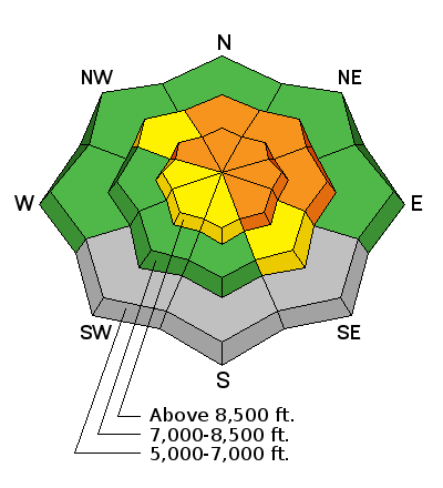
LIKELIHOOD
 LIKELY
UNLIKELY
SIZE
 LARGE
SMALL
TREND
 INCREASING DANGER
SAME
DECREASING DANGER
|
|
description
Triggered persistent slab avalanches remain likely at upper and mid elevations in the backcountry. The prolonged storm overloaded preexisting faceted snow, weakened rapidly last week by a large temperature gradient due to the very cold temperatures in the mountains. A persistent mid-pack weakness made up of small grained near surface facets is apparent in test pits.. ***Dangerous and destructive deep slab avalanches, failing on weak faceted snow or depth hoar near the ground are possible on upper elevation north facing slopes. Here' a video look at the pre-storm snow, 12-8-16, Corner Pocket |
| type | aspect/elevation | characteristics |
|---|

|
|
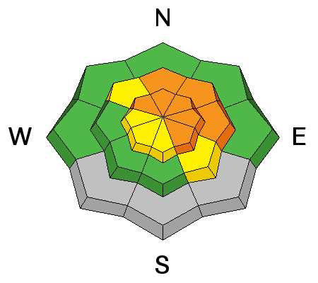
LIKELIHOOD
LIKELY
UNLIKELY
SIZE
 LARGE
SMALL
TREND
INCREASING DANGER
SAME
DECREASING DANGER
|
|
description
Dangerous wind slab avalanche conditions exist on drifted upper elevation slopes in the backcountry. Northwest winds continued overnight and significant drifting occurred in exposed terrain. Breezy conditions and west winds should continue in the mountains today and gradually decrease overnight. Avoid stiffer recently drifted snow on steep slopes. Drifts may appear rounded and chalky and they may produce hollow, drum-like sounds. Watch for deposits of drifted snow in and around terrain features like gullies, scoops, sub-ridges, and cliff-bands. |
 |
weather Westerly flow will remain over the area through mid week. A weak disturbance will clip northern Utah today. A warm front will lift north through the area late Tuesday through late Wednesday. A strong cold trough will move into the region Friday through Saturday. |
| general announcements The early season is a great time to refresh yourself and practice companion rescue techniques with your partners. Companion Rescue Practice Video Check out Avalanche Canada's "Rescue at Cherry Bowl" story HERE Between now and Jan 15th: Donate to the Utah Avalanche Center by shopping at Whole Foods Market Utah! When you visit any Utah Whole Foods Market locations, bring your re-usable bags, Whole Foods will donate a dime per bag to the Utah Avalanche Center - if you say DONATE my bag credit. Remember your information can save lives. If you see anything we should know about, please help us out by submitting snow and avalanche observations. You can also call us at 801-524-5304, email by clicking HERE, or include @utavy in your Instagram. In the Logan Area you can get ahold of your local avalanche forcaster, me (Toby Weed), at 435-757-7578 This advisory is from the U.S.D.A. Forest Service, which is solely responsible for its content. This advisory describes general avalanche conditions and local variations always exist. |


