25th Annual Black Diamond Fall Fundraising Party
Thursday, September 13; 6:00-10:00 PM; Black Diamond Parking Lot
25th Annual Black Diamond Fall Fundraising Party
Thursday, September 13; 6:00-10:00 PM; Black Diamond Parking Lot
| Advisory: Logan Area Mountains | Issued by Toby Weed for Friday - December 9, 2016 - 6:17am |
|---|

|
bottom line Significant accumulations of heavy snow, strong southwest winds, and rising temperatures are creating dangerous avalanche conditions at upper and mid elevations in the backcountry. The danger will continue to increase and become more widespread today, overnight, and as we head into the weekend. Avoid travel in backcountry avalanche terrain, and stay clear of and out from under steep slopes with significant accumulations of storm and/or drifted snow.
|
 |
avalanche warning THE FOREST SERVICE UTAH AVALANCHE CENTER IN SALT LAKE CITY HAS ISSUED A BACKCOUNTRY AVALANCHE WARNING. * TIMING...IN EFFECT THROUGH 600 AM SATURDAY. * AFFECTED AREA...THE MOUNTAINS OF NORTHERN UTAH INCLUDING THE WASATCH RANGE...BEAR RIVER RANGE...AND THE WESTERN UINTA MOUNTAINS. * AVALANCHE DANGER...THE AVALANCHE DANGER WILL BECOME HIGH TODAY AND REMAIN ELEVATED THROUGH THE WEEKEND. * REASON/IMPACTS...DENSE HEAVY SNOW COMBINED WITH STRONG WINDS WILL CREATE WIDESPREAD AREAS OF UNSTABLE SNOW AT THE MID AND UPPER ELEVATIONS. BOTH HUMAN TRIGGERED AND NATURAL AVALANCHES ARE CERTAIN. STAY OFF OF AND OUT FROM UNDER SLOPES STEEPER THE 30 DEGREES. BACKCOUNTRY TRAVELERS SHOULD CONSULT WWW.UTAHAVALANCHECENTER.ORG OR CALL 1-888-999-4019 FOR MORE DETAILED INFORMATION. |
 |
special announcement Our annual Pray for Snow party was obviously a big success, and it worked. The SNOW IS HERE! |
 |
current conditions Careful what you wish for! We finally got a decent snowstorm, but significant accumulations of heavy and inverted snow, strong winds, and rising temperatures are causing dangerous avalanche conditions in the backcountry. Expect the danger to continue to rise throughout today, with a HIGH danger potentially developing and natural avalanche activity becoming possible by tonight. The Tony Grove Snotel reports an even inch of water accumulation in a bit over a foot of new snow overnight. Temperatures have climbed 25 degrees since this time yesterday morning, and I'm reading 27 degrees at 8400'. It's 19 degrees at 9700' at the CSI Logan Peak weather station, with south-southwest winds gusting to around 50 mph and currently averaging in the upper twenties.
|
 |
recent activity A skier remote triggered a wind slab avalanche Sunday afternoon as he was walking along the east ridge of Chicken Hill in the Bunch Grass drainage.
Drifting Sunday created sensitive wind slab avalanche conditions in exposed terrain. (12-4-2016) |
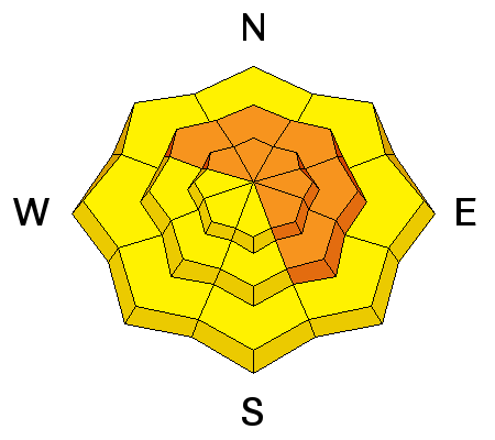
| type | aspect/elevation | characteristics |
|---|

|

|
LIKELIHOOD
 LIKELY
UNLIKELY
SIZE
 LARGE
SMALL
TREND
 INCREASING DANGER
SAME
DECREASING DANGER
|
|
description
Significant accumulations of heavy and inverted new snow, increasingly strong southwest wind, and rising temperatures will cause the danger of storm slab avalanches to rise throughout the day today. The prolonged storm is overloading preexisting shallow faceted snow, weakened rapidly by a large temperature gradient due to the very cold temperatures in the mountains this past week. |
| type | aspect/elevation | characteristics |
|---|

|
|
LIKELIHOOD
LIKELY
UNLIKELY
SIZE
LARGE
SMALL
TREND
INCREASING DANGER
SAME
DECREASING DANGER
|
|
description
Strong and sustained southwest winds overnight drifted snow into lee terrain at upper elevations, and dangerous wind slab avalanche conditions exist in the backcountry. Expect the danger to increase during the day and as we head into the weekend, with significant ongoing and continuing drifting.. |
 |
weather A persistent and quite moist westerly flow aloft will generate significant precipitation across much of northern Utah and southwest Wyoming into early next week. Southern Utah will remain south of the storm track until late in the weekend. |
| general announcements The early season is a great time to refresh yourself and practice companion rescue techniques with your partners. Check out Avalanche Canada's "Rescue at Cherry Bowl" story HERE Between now and Jan 15th: Donate to the Utah Avalanche Center by shopping at Whole Foods Market Utah! When you visit any Utah Whole Foods Market locations, bring your re-usable bags, Whole Foods will donate a dime per bag to the Utah Avalanche Center - if you say DONATE my bag credit. Remember your information can save lives. If you see anything we should know about, please help us out by submitting snow and avalanche observations. You can also call us at 801-524-5304, email by clicking HERE, or include #utavy in your Instagram. In the Logan Area you can get ahold of your local avalanche forcaster, me (Toby Weed), at 435-757-7578 This advisory is from the U.S.D.A. Forest Service, which is solely responsible for its content. This advisory describes general avalanche conditions and local variations always exist. |


.jpg)